
 United Kingdom
 France
 Germany
 Netherlands
 Sweden
 USA
USA
 Italy
Italy
 Spain
Spain
More From Contributor

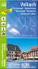


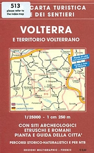
Volterra And Its Environs Edizioni Multigraphic 513
Volterra and its environs at 1:25, 000 in a series of hiking maps from Edizioni Multigraphic covering Tuscany, parts of Umbria, and the adjoining areas. The cartography is rather old fashioned and sometimes not as clear as in the other map series but for many areas, especially for parts of Tuscany, these are the only hiking maps available. Most maps have contours at 25-metre intervals, with some relief shading and colouring for forests. An overprint highlights hiking paths, including all the popular hiking routes such as the Grandi Sentieri della Provincia di Siena, etc. The overprint also shows campsites and, where appropriate, mountain refuges and other types of alpine accommodation. Some of the maps indicate latitude and longitude at the map corners, but with longitude
sometimes based on Rome rather than Greenwich. Map legends vary, most maps include English. Some maps include street plans and additional notes on the region. IN THIS TITLE: the map has contours at 25m intervals and spot heights. Waymarked footpaths are highlighted. No geographical coordinates are provided. On the reverse is an indexed street plan of Volterra with a list of 18 places of interest highlighted on it. Also provided are notes about the town and its sights. Map legend and the notes include English.
sometimes based on Rome rather than Greenwich. Map legends vary, most maps include English. Some maps include street plans and additional notes on the region. IN THIS TITLE: the map has contours at 25m intervals and spot heights. Waymarked footpaths are highlighted. No geographical coordinates are provided. On the reverse is an indexed street plan of Volterra with a list of 18 places of interest highlighted on it. Also provided are notes about the town and its sights. Map legend and the notes include English.

Product Description
Reviews/Comments
Add New
Intelligent Comparison
Archived Product
Florence And Surroundings Edizioni Multigraphic 510 Stanfords
£14.99
Vouchers
No voucher codes found.
Do you know a voucher code for this product or supplier? Add it to Insights for others to use.
Do you know a voucher code for this product or supplier? Add it to Insights for others to use.
 Denmark