More From Contributor
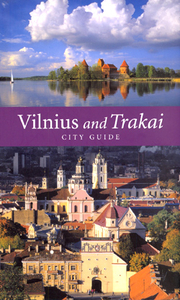
£6.95
Topographic coverage of mainland Spain at 1:50, 000 in the MTN50 (Mapa Topográfico Nacional) series from the Centro Nacional de Información Geografica, the country’s civilian survey organization. The maps have contours at 20m intervals, enhanced by relief shading, plus colouring and/or graphics to show different types of terrain, vegetation or land use. Boundaries of national parks & other protected areas are marked. In addition to all the usual information featured on topographic mapping at this scale, detailed presentation of the road & rail networks, rural tracks & paths, etc, the maps also show campsites & mountain refuges. On more recent editions some GRs, the official long-distance hiking routes, are also marked (although not as clearly as on hiking maps from other publishers). Each map covers 29.5x 18.5 km (with adjustments in the border or coastal areas). The maps have a 1-km UTM grid, plus margin ticks for latitude & longitude at 1` intervals. Map legend is in Spanish only.HOW TO CHOOSE THE RIGHT 50K MAP: all the titles in CNIG’s 200K Provincial Road Maps series at 1:200, 000 are overprinted with the grid for the 1:50, 000 maps & can be used to see the area covered by each 50K title. TO SEE THE LIST OF TITLES IN THIS SERIES PLEASE CLICK ON THE SERIES LINK.PLEASE NOTE
- MAP TITLES: the grids shown on our website serve both the civilian & the military 1:50, 000 topographic series. Although the areas covered by maps in both series are identical (apart from some border or coastal sheets), occasionally map titles differ – only one title is shown on the grid, usually the military one. In Galicia, the Basque country & in the Catalan speaking areas the tendency now is to use local place names rather than the often better known Castilian ones. Where possible, both versions are included in our titles. Map titles listed on our website are based on information received by us at the time of publication, but sometimes maps arrive showing a completely different title! As long as the map number is as ordered, the correct map has been supplied.
...
Archived Product
£15.99
Vilnius – A Guide through the City is a Lithuanian produced guide written in English. Akin to a Dorling Kindersley Eyewitness title in scope & delivery, the book is illustrated with a useful & wide selection of colour photographs & site/attraction plans & maps. A large focus of the guide is on historical Vilnius & the UNESCO Old Town, with a comprehensive overview of the city’s 6 quarters being provided. 11 historical themes of the city are fore grounded, from paganism to the present day, with the most powerful families & famous inhabitants profiled. Detailed descriptions of over 100 visitor sites are given, as well as a calendar of annual events & the expected useful information such as lists of places of accommodation, restaurants & entertainment/attraction options as well as a selection of practical facts & advice. Useable maps are provided amongst the pages including a basic city map, maps of individual quarters & a public transport map. ...
Archived Product
£4.99
Vilnius in New Holland’s “ Best of…” series; comprising a range of pocket-sized guides exploring a variety of cities worldwide. Designed to be practical, informative & user-friendly, each title in the series presents the highlights of the city concisely, providing a directory of the best places to stay, eat, shop & relax. An overview section provides a brief summary of the l&, history, government & economy, people & the arts. Each guide is designed to make essential information easy to access, with individual sections on the city’s main tourist attractions (‘highlights’), in addition to dedicated sections on sightseeing, activities, shopping, accommodation, eating out, entertainment & excursions. There is also a travel tips chapter with practical advice on getting there & around, when to go, communications, emergencies, health, insurance, safety, embassies, money, tipping, electricity, time, toilets & some basic vocabulary. ...
Archived Product
£9.95
Vilnius & Environs at 1:100, 000 in a series GPS compatible regional maps of Lithuania from Alma Littera prominently highlighting each area’s best sights & showing a wide range of other places of interest including campsites. Main roads are graded according to the speed limit; regional & local roads indicate asphalted or gravel routes. Driving distances are marked on main & selected regional routes, & locations of petrol stations & border crossings are marked. Railway lines are shown with stations. Important sights are prominently highlighted & a very wide range of symbols indicate various places of interest, including campsites, historical & industrial heritage, archaeological & natural sites, etc. The maps also indicate hiking, cycling & kayaking routes. Topography is shown by contours & spot heights, plus colouring and/or graphics for different types of the terrain & vegetation, e.g. swamps, peat bog, orchards, forests, etc. The maps have latitude & longitude lines at 5’ & 10’ respectively. Map legend

Includes::
English. Each title comes with a booklet attached to the map cover providing descriptions of places of interest, but the text here is in Lithuanian only.

...
Archived Product
£9.95
Vilnius & Environs in a series of contoured maps at 1:50, 000 from the Vilnius based publishers Briedis covering Lithuania’s popular regions & highlighting each area’s recreational possibilities, tourist facilities, various places of interest, etc. Maps in this series are contoured & have colouring and/or graphics to indicate different types of terrain & vegetation, e.g. peat bogs, marshl&, forests, cultivated areas, etc. Road network indicates gravel roads & shows locations of petrol stations & car repair workshops. Also marked are field & forest paths. Railway lines are shown with stations. An overprint highlights waymarked hiking paths, cycling routes & kayaking/canoeing routes over the lakes & rivers. Symbols indicate various tourist facilities (hotels, rest houses, farmhouse accommodation, campsites, etc), cafes, viewpoints, churches & historical buildings, archaeological sites, etc. The maps have no geographical coordinates. Map legend

Includes::
English. The reverse side provides additional tourist information. Unless indicated to the contrary in the individual description the text, cross-referenced to the map itself, is in Lithuanian only.

...
Archived Product
£6.99
This is the savvy city breakers' pocket guide to seeing & doing more in Vilnius
- with a fun-seeking & cost-conscious slant. It
...
Archived Product
£9.99
Vilnius street plan at 1:12, 000 from Freytag & Berntdt, covering the city with its outer suburbs on a large, single-sided map clearly showing access to the centre from the airport & the motorways connecting it with the rest of Lithuania. The plan highlights main traffic routes across the city & indicates locations of car parks. Various public buildings & institutions are marked, including churches, academic & cultural establishments, monuments, sport facilities, etc. * Map legend

Includes::
English.* Street index is on the reverse of the map.

...
Archived Product
£4.99
Central Vilnius at 1:10, 000 on a pocket-size, indexed street plan from the Riga-based publishers Jana Seta with brief descriptions of the city’s main sights, plus on the reverse a map of the capital with its outer districts at 1:50, 000. The town centre street plan has streets annotated with selected house numbers for easier identification of addresses. Important buildings are highlighted & symbols indicate various facilities including selected hotels & foreign embassies, markets, etc. On the reverse is a map at 1:50, 000 showing the city with its outer districts including the international airport. Map legend & the descriptions include English. ...
Archived Product
£7.99
Vilnius at 1:25, 000 on a detailed plan from Jana Seta with an enlargement for the central districts, bus & trolleybus routes with stops & line numbers, places of interest, locations of petrol stations & car parks, etc. The plan covers the city with its outer districts, highlighting transit routes & very clearly presenting main traffic junctions. Car parks & locations of petrol stations are marked. Bus & trolleybus routes are shown with line numbers & stops & local railway stations with their names. Streets & housing estates have selected house numbers for easier identification of addresses. The plan highlights and/or identifies various public buildings & institutions, as well as selected hotels, embassies, etc. An enlargement shows the Old Town & the New Town district in greater detail. A comprehensive street index is in a separate booklet attached to the map cover.* Map legend

Includes::
English.*

...
Archived Product
£8.99
Vilnius on a waterproof & tear-resistant, indexed street plan from the Riga-based publishers Jana Seta, including on the reverse side an enlargement of the city centre & a diagram of the public transport lines. On one side Vilnius with its outer districts is shown at 1:25, 000. On the reverse the city centre is presented in greater detail at 1:10, 000. Both plans indicate principal traffic arteries, one way streets, car parks & locations of petrol stations. The plans also show bus & trolleybus routes with stops & line numbers. Streets are annotated with selected house numbers for easier identification of addresses. Symbols indicate various places of interest & facilities including embassies. The city centre enlargement also prominently highlights locations of the capital’s 15 best sights, plus selected hotels. Map legend

Includes::
English. Also provided is a diagram of the bus & trolleybus network.

...
Archived Product

Vilnius And Trakai

Vilnius and Trakai is a guide to two ancient cities connected by the history of the formation and thriving of the Lithuanian State. The cities historical streets, remarkable buildings and the most spectacular sites are described in detail, and the guide contains the basic practical information for a tourist. The guide is illustrated with 56 colour photos and city plans marking the location of the sites mentioned in the text.
RIP - This product is no longer available on our network. It was last seen on 25.09.2019

This page now acts as a permanent archive for this product. Add more information using the comments box below to ensure it can still be found by future generations.

Use our search facility to see if it is available from an alternative contributor.
  • External links may include paid for promotion
  • Availability: Out Of Stock
  • Supplier: Stanfords
  • SKU: 9789986830757
Availability: In Stock
£12.99

Product Description

Vilnius & Trakai is a guide to two ancient cities connected by the history of the formation & thriving of the Lithuanian State. The cities historical streets, remarkable buildings & the most spectacular sites are described in detail, & the guide contains the basic practical information for a tourist. The guide is illustrated with 56 colour photos & city plans marking the location of the sites mentioned in the text.

Reviews/Comments

Add New

Intelligent Comparison

Oooops!
We couldn't find anything!
Perhaps this product's unique.... Or perhaps we are still looking for comparisons!
Click to bump this page and we'll hurry up.

Price History

Vouchers

No voucher codes found.
Do you know a voucher code for this product or supplier? Add it to Insights for others to use.

Facebook

Jargon Buster

History - Anything that happens in the past. An acedemic subject.
Colour - The categorised spectrum of light visable to humans
Spectacular - Something that catches that eye due to its eye catchingness.
Practical - Weather a task is easy to carry out and realistically succeed.

Supplier Information

Stanfords
Stanfords was established in 1853 and opened their iconic Covent Garden flagship store in 1901. They have become the top retailer of maps, travel books and accessories in the UK and arguably offer the largest selection of maps and travel books worldwide. Famous names such as Captain Robert Falcon Scott, Ranulph Fiennes and Michael Palin have purchased from Stanfords. They now have a shop in Bristol and both stores together with other venues operate a calendar of events including talks, book signings and exhibitions. As a specialist map retailer, the map selection is comprehensive and includes road maps, street maps and walking maps from worldwide destinations, as well as a selection of world atlases and wall maps. Books include travel guides and travel literature. Stanfords also stock globes, from miniatures made of blue marble to magnificent floor-standing globes. The website features a selection of interesting articles on travel topics.
Page Updated: 2023-11-12 20:15:36

Community Generated Product Tags

Oh No! The productWIKI community hasn't generated any tags for this product yet!
Menu