More From Contributor
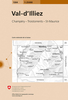
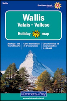
£12.99
Map No. 1304, Val-d` Illiez, in the topographic survey of Switzerland at 1:25, 000 from Bundesamt für Landestopographie (swisstopo), covering the whole country on 247 small format sheets, with special larger maps published for popular regions including some titles now available in hiking versions. Highly regarded for their superb use of graphic relief & hill shading, the maps give an almost 3-D picture of Switzerland`s mountainous terrain. Contours are at 10 m intervals, with 20m intervals in the mountainous areas. All the maps have a 1-km grid for Swiss national coordinates (datum CH 1903). * Small format sheets (Nos. 1011
- 1374)* Map legend in the language of the area covered by the map. Additional margin ticks show latitude & longitude in steps of 2`. The area covered by each map is 17 x 12 km (11 x 7 miles approx). * Special larger sheets (Nos. from 2501 onwards) – STANDARD editions:* No map legend is included but a separate leaflet can be provided instead. The area covered by each map is 25 x 17 km (15 x 11 miles approx).* Special larger sheets (Nos. from 2501 onwards) – HIKING editions:* An overprint highlights hiking, mountain & alpine paths, including regional & national long-distance trails. The maps also show bus routes with bus stops, plus inns in remote locations. The area covered by each map is 25 x 17 km (15 x 11 miles approx).
...
Archived Product
£12.99
Topographic survey of France at 1:25, 000 in IGN`s excellent TOP25 / Série Bleue series. All the maps are GPS compatible, with a 1km UTM grid plus latitude & longitude lines at 5’ intervals. Contours are at 5m intervals except for mountainous areas where the maps have contours at 10m intervals, vividly enhanced by hill shading & graphics for rocky terrain. Colouring with graphics indicates different types of vegetation or land use (deciduous or coniferous forests, moors, orchards, vineyards, etc). PLEASE NOTE: coverage of France at this scale is currently being revised – the format & the presentation of each title are indicated by the letters at the end of its Sheet Reference number (e.g. 0416ET, 3531ETR, 1923SB, etc.)MAPS WITH FULL TOURIST OVERPRINT & AN ENGLISH MAP LEGEND: all TOP25 maps & the SB editions of Série Bleue have an overprint highlighting waymarked walking trails including long-distance GR routes &, where appropriate, ski routes. Symbols indicate campsites, gîtes d’etape, refuges, equestrian centres & other recreational facilities or sites, tourist information centres, cultural heritage, etc. Towns & locations of particular interest are highlighted.- ET or OT = single-sided TOP25 map covering approx. 29x 21 km / 18x 13 miles.- ETR or OTR = waterproof & tear resistant TOP25 map covering the same area as the corresponding ET or OT number, but double-sided, printed on a smaller size sheet with a good overlap between the sides.- SB = Série Bleue map with full tourist overprint; these maps, first introduced in summer 2014, each cover approx. 29x 24km / 18x 15 miles.SÉRIE BLEUE maps with numbers ending in E (Est) or O (Ouest): most editions now indicate the GR routes, but do not show any other tourist information. Map legend is in French only. Each map covers approx. 14x 20km / 9x 12 miles. ...
Archived Product
£16.99
Mountain areas of central & northern Sweden on waterproof & tear-resistant, GPS compatible topographic “ Fjällkartan” maps at 1:100, 000 & 1:50, 000 from Lantmäteriet
- the country’s national survey organization, with hiking & ski routes, campsites & youth hostels, etc. Relief is shown by contours at 20m intervals & enhanced by relief shading, plus colouring and/or graphics to indicate different types of vegetation or land use. An overprint shows trails for hiking & cross-country skiing, indicating waymarked or unmarked & summer or winter only routes. Also shown are mandatory & recommended trails for snowmobiles & areas prohibited for cross-country vehicles. Symbols indicate locations of campsites, youth hostels, huts & wind shelters, mountain lodges & other types of tourist accommodation, emergency telephones, etc. The maps have both a 1-km UTM grid & a latitude/longitude grid in steps of 10`. Map legend

Includes::
English. On the reverse there are descriptions of the area in Swedish only, GPS coordinates for selected locations, etc. Most sheets also include a brief note in English on public access regulations. To see the list of titles in this series please click on the series link.


...
Archived Product
£8.99
Valais- Switzerland in the Landmark Visitor Guides series, exploring a range of places in Britain, Europe & the Caribbean, with a particular expertise in UK destinations. Each guide presents the reader with detailed, wide-ranging & accessible overview of the region or area, with a particular focus on history & culture, notable local attractions, the landscape, local events & family activities. A series of recommended walks & guided car tours exploring the region are also included in each title. The guides are arranged geographically by region & are ideal both for short & longer breaks, with practical guidance on recommended routes & tourist attractions, in addition to insightful inset boxes into local history, culture & traditions. Information on accommodation, restaurants & day-to-day information are more limited, though a compact Directory at the end of each guide provides basic listings of recommended accommodation & restaurants, as well as tourist information contacts & regional event calendars. International destinations also carry climate & country facts, basic phrases & other general travel practical guidance for travelling to the region. The British titles in the Landmark Visitor Guides series are highly recommended, covering titles that are rarely available from other publishers. ...
Archived Product
£102.99
Fourth title of a series of 8 DVDs covering the whole country. About this series: The Swiss Map 25 series covers the whole of the country at 1:25, 000,

Includes::
the complete official Swiss footpath network & it is compatible with both Swiss Map 50 & 100, & with the Dufour Map. There are 8 DVD titles in the series, each also including the Swiss Map 500 covering the whole country. The cartography of Swiss Map 25 is equivalent to that of the printed Swiss Survey maps & the individually selectable map extracts can be easily printed & exported. The diversity of the graphic tools makes it possible to show political & administrative boundaries (including municipalities, districts & cantons), highlight castles, heritage sites & other tourist information, & search for all displayed place names. It is also possible to calculate distances, hiking times & profiles' elevation, to enter individual routes or add personal data to a map. Up-to-date information from the Switzerland Tourism organisation about holiday destinations, hotels, events & excursions can also be accessed from the map via the Internet. Each DVD is compatible with Windows, Mac & GPS (NMEA, Garmin & Magellan). All data is available in English, German, French & Italian. System requirements:1 GB free hard disk space Screen 1024 x 768 pixels Thousands of colours (16 bits) Internet Browser 4.x (or higher) Windows
- 2000 or XP
- Pentium processor III
- 256 MB RAMMacintosh
- Mac OS X 10.1.5 (or higher)
- G3 500 MHz
- 256 MB RAM


...
Archived Product
£8.99
Beautiful panorama drawing of the canton, viewed looking southwards from the peaks of the Bernese Oberland across the Rhone Valley towards the highest part of the Swiss Alps, with the Italian & French Alps in the background. Each valley & mountain is clearly visible. Names & altitude are indicated for numerous peaks. The map also shows the railway network, with towns & villages. Excellent for planning or retracing journeys across this wonderful landscape. ...
Archived Product
£20.99
Swiss canton of Valais / Wallis on a Swiss topographic survey map at 1:100, 000. Coverage extends from Chamonix & Mont Blanc eastwards to include many of the most popular destinations in the Swiss Alps: the Mattertal with Zermatt, Randa & St. Niklaus, Saas Fee, Verbier, Crans-Montana, the peaks of Matterhorn, Dom with the Michabel range, Monte Rosa, Simplon Pass, etc. Current 2015 edition of this title has the lines of the Swiss National Grid at 1km intervals. Maps in the Swiss topographic survey at 1:100, 000 from Swisstopo are highly regarded for their superb use of graphic relief & hill shading, presenting an almost 3-D picture of the country`s mountainous terrain. Coverage is available either as small size standard sheets – Nos 26 to 48, each covering 70 x 48 km / 43 x 30 miles approx, or as larger size maps
- Nos. 101 onwards, each covering 100 x 70 km / 62 x 43 miles approx. Both formats have identical cartography, with contours at 50-metres intervals. Standard sheets include margin ticks showing latitude & longitude in steps of 10`, & both formats have an overprint showing the Swiss national grid lines at 10km intervals; latest editions of the larger sheets now have the Swiss grid lines at 1km intervals. Standard sheets have a map legend in the language of the area covered by the map. The larger sheets have no legend but a separate “ Conventional Signs” leaflet, in English, can be provided with the map. To see the list of titles in this series please click on the series link.
...
Archived Product
£19.50
Selected climbs in the western part of the Valais Alps, where there are many peaks between 3000-4000m & some, like the Matterhorn, over 4000m. Routes described are of all grades, from easy to extremely difficult, on snow, ice & rock.

Includes::
97 photographs of mountains with routes overlaid. This volume replaces Collomb's Pennine Alps west (1979) & part of his Pennine Alps Central (1975). About this series: Compact & portable mountain climbing guides. Each guide is organized by mountain group, with individual ascents described & graded by difficulty. Photographs are included, with recommended routes superimposed. General information is also included about the local area. Vinyl covered for durability.

...
Archived Product
£19.99
The new Supertrail Maps show the best singletrails in Europe’s hottest mountain bike spots. These unique topographic maps make the knowledge of locals available to other mountain bikers. Consistent difficulty rating & useful additional information prevent the user from critical situations on the trails. The best singletrails in the best mountain bike spots throughout Europe
- this is the convincing formula of the brand new Supertrail Maps. For the first time ever, these unique topographic maps make the knowledge of locals available to others. All the trails on a map have been biked & rated in five difficulty levels for up- & downhill separately by specially trained authors. This consistent rating facilitates tour planning & spares a user from getting into sketchy situations on the trails. In addition to the difficulty rating, extraordinary nice trails are marked with a «highlight»-pictogram. The maps in a scale of 1:50 000 show all information required for tour planning & orienting oneself on the trails, such as: difficulty, highlight-trails, mountain railways with mountain bike transport, mountain bike shuttles, dangerous falls, restaurants, bike shops, emergency numbers & touristic infopoints. Thanks to the especially chosen map section, one map covers the whole area. The Supertrail Maps are printed on tear- & waterproof foil which makes them very sturdy. On the back of any map, additional information about the area & the use of a Supertrail Map are presented in two languages. Folded

Dimensions of 10x 15cm allow the map to fit into any pocket without squeezing.


...
Archived Product
£15.99
About this series: Rother Walking Guides were first published in 1920- since then Bergverlag Rother have continued to produce these comprehensive guides to “the finest valley & mountain walks”. Each book has a detailed description of walks, small walking maps & many tips on combining the walks, places of interest, accommodation & public transport; the guides are all in full colour with varying scales & types of cartography
- the walks themselves vary from day-long hikes to mountain & valley walks, with varying levels of ease & difficulty indicated. Small enough to fit in your pocket, comprehensive enough to take you everywhere; the books are printed in paperback but with a polytex-laminated cover, making them extremely durable too.
...
Archived Product

Valais / Wallis

The mountains of the Swiss canton of Valais / Wallis on a contoured and GPS compatible map at 1:120, 000 from Kümmerly + Frey, useful for planning walking holidays by indicating access to hiking trails by public transport. Coverage includes the Mattertal with Zermatt, Randa and St. Niklaus, the Saastal with Saas-Fee, also Arolla, Evolène, etc. The map shows the Tour of Monte Rosa, the western part of the Alpine Pass Route, the local section of Via Francigena, and several other long-distance footpaths.Maps in Kümmerly + Frey‘s Holiday Series have contours at 100-metre intervals, enhanced by shading and graphic relief to provide a vivid presentation of the terrain. An overprint highlighting walking trails distinguishes between hiking paths, more strenuous mountain routes and
alpine sections. Symbols indicate locations of mountain huts, Friends of Nature houses, youth hostels, campsites and selected isolated inns, interesting natural curiosities, etc. Picturesque towns or villages are prominently highlighted and the maps also show roads with public transport facilities plus, of course, railways and all forms of mountain transport (cable cars, chair lifts, etc). The maps have Swiss national grid lines at 5km intervals. Map legend includes English.To see the list of titles in this series please click on the series list.
RIP - This product is no longer available on our network. It was last seen on 25.09.2019

This page now acts as a permanent archive for this product. Add more information using the comments box below to ensure it can still be found by future generations.

Use our search facility to see if it is available from an alternative contributor.
  • External links may include paid for promotion
  • Availability: Out Of Stock
  • Supplier: Stanfords
  • SKU: 9783259009055
Availability: In Stock
£19.99

Product Description

The mountains of the Swiss canton of Valais / Wallis on a contoured & GPS compatible map at 1:120, 000 from Kümmerly + Frey, useful for planning walking holidays by indicating access to hiking trails by public transport. Coverage

Includes::
the Mattertal with Zermatt, Randa & St. Niklaus, the Saastal with Saas-Fee, also Arolla, Evolène, etc. The map shows the Tour of Monte Rosa, the western part of the Alpine Pass Route, the local section of Via Francigena, & several other long-distance footpaths. Maps in Kümmerly + Frey‘s Holiday Series have contours at 100-metre intervals, enhanced by shading & graphic relief to provide a vivid presentation of the terrain. An overprint highlighting walking trails distinguishes between hiking paths, more strenuous mountain routes & alpine sections. Symbols indicate locations of mountain huts, Friends of Nature houses, youth hostels, campsites & selected isolated inns, interesting natural curiosities, etc. Picturesque towns or villages are prominently highlighted & the maps also show roads with public transport facilities plus, of course, railways & all forms of mountain transport (cable cars, chair lifts, etc). The maps have Swiss national grid lines at 5km intervals. Map legend

Includes::
English. To see the list of titles in this series please click on the series list.

Reviews/Comments

Add New

Intelligent Comparison

Oooops!
We couldn't find anything!
Perhaps this product's unique.... Or perhaps we are still looking for comparisons!
Click to bump this page and we'll hurry up.

Price History

Vouchers

No voucher codes found.
Do you know a voucher code for this product or supplier? Add it to Insights for others to use.

Facebook

Jargon Buster

GPS - Global Positioning System - Global position using satellites
Hiking - An outdoor activity envolving walking in nature
swiss - Short for Switzerland, one of the richest countries in the world
Cable - A series of wires bonded to form a single thread
Friends - A close associate or a popular US based sitcom about a group of friends
Railways - A set of tracks that have been laid for the purpose of trains to travel up and down them
Natural - not manmade
Metre - 100cm. A unit of length.
Transport - Something that carries people or goods.

Supplier Information

Stanfords
Stanfords was established in 1853 and opened their iconic Covent Garden flagship store in 1901. They have become the top retailer of maps, travel books and accessories in the UK and arguably offer the largest selection of maps and travel books worldwide. Famous names such as Captain Robert Falcon Scott, Ranulph Fiennes and Michael Palin have purchased from Stanfords. They now have a shop in Bristol and both stores together with other venues operate a calendar of events including talks, book signings and exhibitions. As a specialist map retailer, the map selection is comprehensive and includes road maps, street maps and walking maps from worldwide destinations, as well as a selection of world atlases and wall maps. Books include travel guides and travel literature. Stanfords also stock globes, from miniatures made of blue marble to magnificent floor-standing globes. The website features a selection of interesting articles on travel topics.
Page Updated: 2023-11-12 20:15:36

Community Generated Product Tags

Oh No! The productWIKI community hasn't generated any tags for this product yet!
Menu