
 United Kingdom
 France
 Germany
 Netherlands
 Sweden
 USA
USA
 Italy
Italy
 Spain
Spain
More From Contributor


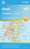


Umeå
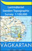
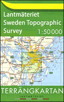
Topographic survey of Sweden at 1:50, 000, the Terrängkartan, from the Lantmäteriet, covering most of the country in 244 double-sided maps. Please note: the mountainous regions of central and northern Sweden are not covered by this series but presented in a separate “Fjällkartan - Mountain Map” series also listed on our website.Each 1:50, 000 topographic survey map covers an area of 37.5 x 40km. The maps have contours at 5 metre intervals, plus relief shading and graphics for rocky outcrops and boulders. Further graphics and/or colouring show different types of land use or vegetation (forests, arable land, orchards, marshes, peat bogs, etc). An unusual feature of this survey is the colouring indicating buildings below or above two storeys high and “leisure/holiday
homes”. The maps indicate privately maintained roads and include all other information expected of topographic survey at this scale. The maps have a 1-km UTM grid, plus latitude and longitude lines 5’ intervals. Map legend includes English.For coverage of the country’s most visited hiking areas in central and northern Sweden please see Lantmäteriet’s Mountain Map series, listed separately on our website.
homes”. The maps indicate privately maintained roads and include all other information expected of topographic survey at this scale. The maps have a 1-km UTM grid, plus latitude and longitude lines 5’ intervals. Map legend includes English.For coverage of the country’s most visited hiking areas in central and northern Sweden please see Lantmäteriet’s Mountain Map series, listed separately on our website.

Product Description
Reviews/Comments
Add New
Vouchers
No voucher codes found.
Do you know a voucher code for this product or supplier? Add it to Insights for others to use.
Do you know a voucher code for this product or supplier? Add it to Insights for others to use.
 Denmark