
 United Kingdom
 France
 Germany
 Netherlands
 Sweden
 USA
USA
 Italy
Italy
 Spain
Spain
More From Contributor


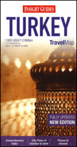
Turkey Insight Travel Map
Turkey on a large, indexed map from Insight Guides, presenting on one side the western half of the country at 1:800, 000 with street plans of Istanbul and Izmir, with the reverse side providing coverage of the whole country at 1:2, 000, 000.Coverage at 1:800, 000 extends east to Ankara and Konya (so does not include Cappadocia). Relief shading shows the topography with names of mountain ranges and main peaks. National parks and protected areas are highlighted. Both principal highways and connecting secondary roads are clearly numbered, with driving distances shown on main routes. Railway lines and airports are marked, as well as ferry routes, including connections to the Greek islands in the Aegean. Road maps from the Insight Guides indicate towns worth visiting and include a wide
range of small icons prominently highlighting various places of interest. The map has no geographical coordinates. The Greater Istanbul area is shown in more detail on an enlargement; street plans cover the old historic part of Istanbul and central Izmir; another panel shows the whole of the Aegean with ferry connections and contact details for ferry companies.The reverse side has a map of the whole country at 1:2, 000, 000, plus indexes for the 800K and 2M maps and the two street plans.
range of small icons prominently highlighting various places of interest. The map has no geographical coordinates. The Greater Istanbul area is shown in more detail on an enlargement; street plans cover the old historic part of Istanbul and central Izmir; another panel shows the whole of the Aegean with ferry connections and contact details for ferry companies.The reverse side has a map of the whole country at 1:2, 000, 000, plus indexes for the 800K and 2M maps and the two street plans.

Product Description
Reviews/Comments
Add New
Vouchers
No voucher codes found.
Do you know a voucher code for this product or supplier? Add it to Insights for others to use.
Do you know a voucher code for this product or supplier? Add it to Insights for others to use.
 Denmark