More From Contributor
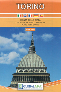
£21.99
Saariselkä Kiilopää area of Finland at 1:50, 000 in a series of beautiful & informative maps of popular outdoor leisure areas with cartography of the country’s topographic survey. Excellent use of colours, shading & symbols provides a very detailed picture of the terrain & vegetation. Extensive overprint highlights routes for hiking, and/or other outdoor pursuits, a wide variety of accommodation, from hotels & holiday villages to Lapland tepees, food & fuel supplies, etc. The maps have a UTM grid & margin ticks for latitude & longitude. Map legends include English. ...
Archived Product
£7.99
The D-day landings: the fate of 2.5 million men, 3000 landing craft & the entire future of Europe depends on the right weather conditions on the English Channel on a single day. A team of Allied scientists is charged with agreeing on an accurate forecast five days in advance. But is it even possible to predict the weather so far ahead? & what is the relationship between predictability & turbulence, one of the last great mysteries of modern physics? Wallace Ryman has devised a system that comprehends all of this
- but he is a reclusive pacifist who stubbornly refuses to divulge his secrets. Henry Meadows, a young maths prodigy from the Met Office, is sent to Scotland to discover Ryman`s system & apply it to the Normandy landings. But turbulence proves more elusive than anyone could have imagined & events, like the weather, begin to spiral out of control.
...
Archived Product
£9.99
The brilliant new short story sequence from the Man Booker-shortlisted author of All That Man Is Twelve people on the move around planet Earth, twelve individual lives, each in turmoil, & each in some way touching the next. In this nuanced & deeply moving sequence, David Szalay’s diverse protagonists circumnavigate the world in twelve plane journeys, from London to Madrid, from Dakar to Sao Paulo, to Toronto, to Delhi, to Doha, en route to see lovers & parents, children & siblings, or nobody at all. Along the way, Szalay deftly depicts the ripple effect that, knowingly or otherwise, a person’s actions have on those around them, & invites us to consider our own place in the vast & delicately balanced network of human relationships that is the world we live in today. ...
Archived Product
£6.95
Topographic coverage of mainland Spain at 1:50, 000 in the MTN50 (Mapa Topográfico Nacional) series from the Centro Nacional de Información Geografica, the country’s civilian survey organization. The maps have contours at 20m intervals, enhanced by relief shading, plus colouring and/or graphics to show different types of terrain, vegetation or land use. Boundaries of national parks & other protected areas are marked. In addition to all the usual information featured on topographic mapping at this scale, detailed presentation of the road & rail networks, rural tracks & paths, etc, the maps also show campsites & mountain refuges. On more recent editions some GRs, the official long-distance hiking routes, are also marked (although not as clearly as on hiking maps from other publishers). Each map covers 29.5x 18.5 km (with adjustments in the border or coastal areas). The maps have a 1-km UTM grid, plus margin ticks for latitude & longitude at 1` intervals. Map legend is in Spanish only.HOW TO CHOOSE THE RIGHT 50K MAP: all the titles in CNIG’s 200K Provincial Road Maps series at 1:200, 000 are overprinted with the grid for the 1:50, 000 maps & can be used to see the area covered by each 50K title. TO SEE THE LIST OF TITLES IN THIS SERIES PLEASE CLICK ON THE SERIES LINK.PLEASE NOTE
- MAP TITLES: the grids shown on our website serve both the civilian & the military 1:50, 000 topographic series. Although the areas covered by maps in both series are identical (apart from some border or coastal sheets), occasionally map titles differ – only one title is shown on the grid, usually the military one. In Galicia, the Basque country & in the Catalan speaking areas the tendency now is to use local place names rather than the often better known Castilian ones. Where possible, both versions are included in our titles. Map titles listed on our website are based on information received by us at the time of publication, but sometimes maps arrive showing a completely different title! As long as the map number is as ordered, the correct map has been supplied.
...
Archived Product
£8.95
Map No. 82, Tures/ Taufers
- Valle Aurina/ Ahrntal, from Kompass in a series of walking maps of selected areas of Italy at 1:50,
...
Archived Product
£7.95
Turin in a series of street plans of Italian cities from Touring Club Italiano, with exceptionally clear & beautiful cartography. The plan is printed on very light, waterproof & rear-resistant plastic paper &

Includes::
a detailed road map of the city

...
Archived Product
£11.99
The new Moleskine City Notebooks are ideal for those who travel, whether to see the sights or for work, as a way of organising trips & to preserving it for memories & records. It is perfect for those who live there, as a way of organising the things they know & need about the city they live in. Each notebook has an elastic closure, 228 pages, with up to 44 pages in colour & have a sewn binding. There is an inside accordion pocket & three ribbon placemarkers, each in a different colour. ...
Archived Product
£10.99
Turin (Torino) at 1:16, 000 on indexed street plan from Litografia Artistica Cartografica in their Globalmap imprint, with a large detailed enlargement of the city’s historic centre at 1:8, 500. 48 monuments including historic buildings & churches, cultural or educational institutions, & important municipal buildings or facilities are numbered & listed next to the plan. The city’s metro line & its stations, as well as car parks in the centre are prominently marked. Coverage

Includes::
Stadio delle Alpi ground of Juventus. Also provided is a road map showing access to the city from the surrounding motorways. Litografia Artistica Cartografica (LAC) are Italy’s leading publishers of street plans with an extensive range of titles. Where appropriate, the plans include an enlargement showing the historic centre in greater detail. On each plan monuments including historic buildings & churches, archaeological sites, cultural or educational institutions, & important municipal buildings or facilities are numbered & listed next to the plan. Unless indicated to the contrary in the individual description, one way streets are not marked. Street index is on the reverse.

...
Archived Product
£13.99
Turin
- Pinerolo
- Lower Susa Valley area of Piedmont in a series contoured hiking maps at 1:50, 000 with local trails, long-distance

...
Archived Product
£120.00
Turin, an original antique map by S.D.U.K., published in London, 1844. Steel plate, uncoloured. Map size 38 x 31 cm, overall mounted size 52.5 x 46.5 cm.A detailed map of Turin published by the Society for the Diffusion of Useful Knowledge. The Society was founded by John, Earl Russell, & Henry Brougham, later Lord Chancellor of England in 1827. The Society's main purpose was to encourage universal literacy by publishing numbers of books of good quality that would be affordable to all. These town plans were published in perhaps the grandest of the Society's publications
- their atlas entitled Maps Of The Society For The Diffusion Of Useful Knowledge, first issued by Baldwin & Cradock, & then re-issued by other publishers, including Chapman & Hall & latterly Edward Stanford. The map

Includes::
three vignettes, a view of Turin, a view of a Church called La Superga near Turin, & the Royal Palace. The map was engraved by J. Henshall after W.B. Clarke. Antique maps from various original publishers are presented on the Stanford


...
Archived Product

Turin

Turin in a series of street plans of Italian cities from Touring Club Italiano, with exceptionally clear and beautiful cartography. The plan is printed on very light, waterproof and rear-resistant plastic paper and includes a detailed road map of the city
RIP - This product is no longer available on our network. It was last seen on 25.09.2019

This page now acts as a permanent archive for this product. Add more information using the comments box below to ensure it can still be found by future generations.

Use our search facility to see if it is available from an alternative contributor.
  • External links may include paid for promotion
  • Availability: Out Of Stock
  • Supplier: Stanfords
  • SKU: 9788836546473
Availability: In Stock
£7.95

Product Description

Turin in a series of street plans of Italian cities from Touring Club Italiano, with exceptionally clear & beautiful cartography. The plan is printed on very light, waterproof & rear-resistant plastic paper &

Includes::
a detailed road map of the city

Reviews/Comments

Add New

Price History

Vouchers

No voucher codes found.
Do you know a voucher code for this product or supplier? Add it to Insights for others to use.

Facebook

Jargon Buster

Paper - A thin sheet mainly used for writing. Available in a variety of colours. Made mainly from wood pulp.
Plastic - A generic term for a synthetic product used in the manufacture of products
Italian - A word used ot descibe something from Italy
Waterproof - Resistant to water, usualy specified by depth in metres
Road - a manmade lane or a path that is used to speed up travel.
Resistant - Something that can repel against something.

Supplier Information

Stanfords
Stanfords was established in 1853 and opened their iconic Covent Garden flagship store in 1901. They have become the top retailer of maps, travel books and accessories in the UK and arguably offer the largest selection of maps and travel books worldwide. Famous names such as Captain Robert Falcon Scott, Ranulph Fiennes and Michael Palin have purchased from Stanfords. They now have a shop in Bristol and both stores together with other venues operate a calendar of events including talks, book signings and exhibitions. As a specialist map retailer, the map selection is comprehensive and includes road maps, street maps and walking maps from worldwide destinations, as well as a selection of world atlases and wall maps. Books include travel guides and travel literature. Stanfords also stock globes, from miniatures made of blue marble to magnificent floor-standing globes. The website features a selection of interesting articles on travel topics.
Page Updated: 2023-11-12 20:15:36

Community Generated Product Tags

Oh No! The productWIKI community hasn't generated any tags for this product yet!
Menu