More From Contributor
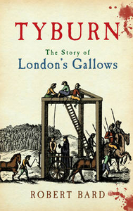
£12.99
Two Wheels in the Dust: From Kathmandu to Kandy covers Anne Mustoe’s amazing trip by bicycle from the mountains of Nepal, across the hectic cities of India, to the tranquil charm of Sri Lanka’s ancient capital Kandy. The author interweaves her evocative descriptions of her journey, full of keen observations & enjoyment of the open road, with the story of the Sanskrit epic The Ramayana. ...
Archived Product
£10.99
As bicycle races go, the attractions of the Tour Divide are not immediately apparent. For a start, it is the longest mountain-bike race in the world, running nearly 3, 000 miles down the Rockies from Canada to Mexico. But the distance is not the only challenge
- the total ascent of 200, 000 ft is the equivalent of scaling Mount Everest nearly seven times. Then there are the dangerous animals likely to be encountered on the route: grizzly bears, mountain lions & wolves, not to mention rattlesnakes & tarantulas. Worse, the rewards for all this effort are strictly limited. Unlike in the Tour de France, there is no fabled yellow jersey & no prize money. Yet, undaunted, & in spite of never having owned a mountain bike, Paul Howard signed up. Battling the worst weather for generations, drinking whiskey with a cowboy & singing karaoke with the locals, Howard`s journey turned into more than just a race
- it became the adventure of a lifetime.

...
Archived Product
£8.99
In the near future, after a storm strikes New York City, the strangenesses begin. A down-to-earth gardener finds that his feet no longer touch the ground. A graphic novelist awakens in his bedroom to a mysterious entity that resembles his own sub-Stan Lee creation. Abandoned at the mayor`s office, a baby identifies corruption with her mere presence, marking the guilty with blemishes & boils. A seductive gold digger is soon tapped to combat forces beyond imagining. Unbeknownst to them, they are all descended from the whimsical, capricious, wanton creatures known as the jinn. Centuries ago, Dunia, a princess of the jinn, fell in love with a mortal man of reason. Together they produced an astonishing number of children, unaware of their fantastical powers, who spread across generations in the human world. Once the line between worlds is breached on a grand scale, Dunia`s children & others will play a role in an epic war between light & dark spanning a thousand & one nights
- or two years, eight months, & twenty-eight nights. It is a time of enormous upheaval, in which beliefs are challenged, words act like poison, silence is a disease, & a noise may contain a hidden curse.
...
Archived Product
£18.99
From Salman Rushdie, one of the great writers of our time, comes a spellbinding work of fiction that blends history, mythology, & a timeless love story. A lush, richly layered novel in which our world has been plunged into an age of unreason, Two Years Eight Months & Twenty-Eight Nights is a breathtaking achievement & an enduring testament to the power of storytelling. In the near future, after a storm strikes New York City, the strangenesses begin. A down-to-earth gardener finds that his feet no longer touch the ground. A graphic novelist awakens in his bedroom to a mysterious entity that resembles his own sub-Stan Lee creation. Abandoned at the mayor`s office, a baby identifies corruption with her mere presence, marking the guilty with blemishes & boils. A seductive gold digger is soon tapped to combat forces beyond imagining. Unbeknownst to them, they are all descended from the whimsical, capricious, wanton creatures known as the jinn, who live in a world separated from ours by a veil. Centuries ago, Dunia, a princess of the jinn, fell in love with a mortal man of reason. Together they produced an astonishing number of children, unaware of their fantastical powers, who spread across generations in the human world. Once the line between worlds is breached on a grand scale, Dunia`s children & others will play a role in an epic war between light & dark spanning a thousand & one nights
- or two years, eight months, & twenty-eight nights. It is a time of enormous upheaval, in which beliefs are challenged, words act like poison, silence is a disease, & a noise may contain a hidden curse. Inspired by the traditional `wonder tales` of the East, Salman Rushdie`s novel is a masterpiece about the age-old conflicts that remain in today`s world. Two Years Eight Months & Twenty-Eight Nights is satirical & bawdy, full of cunning & folly, rivalries & betrayals, kismet & karma, rapture & redemption.
...
Archived Product
£12.99
In October 1887 the writer & translator Lafcadio Hearn sailed from New York to Martinique. Intending to stay for a few months, he remained for two years. He viewed French-ruled Martinique as an exotic fusion of European, African & Asian influences, the Creole society par exellence. Describing the island`s landscape, its flora & fauna, its colonial architecture & rural villages, he provides a picture of a Caribbean colony where slavery was a recent memory & race an all-importan matter of identity. First published in 1890, this work also offers an evocation of the doomed city of Saint Pierre, devastated 12 years later in a volcanic eruption. Hearn also presents insights into the daily lives of Martinicans. Exploring their folk tales, music & Creole language, he portrays a world of sensuality & mystery, in which traditional storytelling conjures up a dimension of sorcery, ghosts & zombies. ...
Archived Product
£3.50
Tyldesley & Atherton South East in 1905 in a fascinating series of reproductions of old Ordnance Survey plans in the Alan Godfrey Editions, ideal for anyone interested in the history of their neighbourhood or family. The map covers most of the town of Tyldesley, with a portion of Atherton in the north-western corner. Features in Tyldesley include railway with station, St George`s Bank Colliery, St George`s church, Barnfield Cotton Mills, Yew Tee Colliery, Green`s Siding, Shakerley Colliery (Wellington Pit & Nelson Pit), Eckersley Farm, Hope Cotton Mill, Field Cotton Mill, Fulwell House, Shuttle Street, Westfield Mill, Chanters Colliery, several mineral lines, tramways, Shakerley Road. At Atherton features include St John`s church, Unitarian Chapel, etc. A 1918 directory of Tyldesley is on the reverse. About the Alan Godfrey Editions of the 25” OS Series: Selected towns in Great Britain & Ireland are covered by maps showing the extent of urban development in the last decades of the 19th & early 20th century. The plans have been taken from the Ordnance Survey mapping & reprinted at about 15 inches to one mile (1:4, 340). On the reverse most maps have historical notes & many also include extracts from contemporary directories. Most maps cover about one mile (1.6kms) north/south, one & a half miles (2.4kms) across; adjoining sheets can be combined to provide wider coverage.FOR MORE INFORMATION & A COMPLETE LIST OF ALL AVAILABLE TITLES PLEASE CLICK ON THE SERIES LINK. ...
Archived Product
£5.99
Tyne & Wear Cycle Map at 1:110, 000 from Sustrans, including Sea to Sea route, Hadrian`s Wall Cycleway, Reivers Route, Coast & Castles South route, & Three Rivers route, plus five day rides: Hexam Loop, Amble Loop, Bardon Mill Loop, Morpeth Loop, & Chester-le-Street Loop. Street plans show Newcastle-on-Tyne & Gateshead, Sunderl&, Chester-le-Street, Consett & Hexam. Maps is this Sustrans series show all the National & Regional Cycle Network routes clearly numbered & have the colouring distinguishing between the on-road & traffic-free sections. The publishers’ own recommendations are shown in contrasting colour &, in most titles, are in addition presented on the reverse side on separate panels where each circuit is annotated with useful notes. The maps have contours & altitude colouring to show the topography, with additional gradient markings. Towns along the routes are annotated with symbols indicating what facilities can be found there. Also marked are various places of interest, on or near the routes, & railway lines are shown with stations for access to the routes by rail. On the reverse each title also provides large, clear city centre street plans of main towns, highlighting the Cycle Network and/or the recommended routes. Also included are contact details of tourist information centres. To see the list of titles in this series please click on the series link. ...
Archived Product
£12.95
Tyne & Wear Street Atlas from the Geographers` A-Z Map Company in a spiral-bound format slightly smaller than A4 & covering the whole metropolitan county plus the northern part of County Durham at 1:14, 908 (4.25” to 1 mile). More detailed mapping at 1:10, 560 (6” to 1 mile) shows central Newcastle with Gateshead, plus at 1:7, 454 (8.5” to 1 mile) central Sunderland & Durham. Current edition of this title was published in 2014. To see other titles in this series of A-Z county street atlases please click on the series link. A-Z also publish street atlases in a smaller A5 paperback format covering towns & cities with their surrounding areas
- for a list of titles in that series please search for SI00000932. Most A-Z county street atlases are in a spiral-bound format just smaller than A4 size, Most titles offer coverage of only the built-up areas, with selected titles covering the whole county
- as indicated in the individual descriptions & our area coverage images. Motorways plus A & B roads are highlighted by colouring & show route numbers. One way or restricted access streets, Park & Ride facilities & selected car parks are marked, as are locations of speed cameras. Also shown are selected cycleway routes. Where appropriate, A & B roads are annotated with selected house numbers for easier identification of addresses. Railway lines are shown with stations & level crossings. Colouring indicates different types of buildings: educational, hospitals & healthcare, industrial, leisure & recreational, shopping centres & markets, public buildings, & places of interest. Symbols mark locations of facilities usually indicated on street mapping: post offices, emergency services, public toilets, etc. Also marked are postcode & local authority boundaries. Each page has the lines & coordinates of the British National Grid. All the titles have a comprehensive index including, unless specified to the contrary in the description, separate entries for places of interest such as cultural & sport or recreational facilities, historical sites, nature reserves & gardens. Many titles include a separate list of hospitals & hospices in the area covered by the atlas.

...
Archived Product
£3.50
Tynemouth in 1913 in a fascinating series of reproductions of old Ordnance Survey plans in the Alan Godfrey Editions, ideal for anyone interested in the history of their neighbourhood or family. The map covers the northern section of Tynemouth, stretching from Donkin Terrace & Oxford Street northward to Long Sands & Bears Head Rock. Features include Prior`s Park, Northumberland Park, Church of the Holy Saviour, Tynemouth Castle, North Pier, Sharpness Point & the Railway Line & Station. Main streets include part of Tynemouth Road, Percy Park Road, Grand Parade & Front Street. On the reverse is an extract from a directory showing private residents & public institutions. About the Alan Godfrey Editions of the 25” OS Series: Selected towns in Great Britain & Ireland are covered by maps showing the extent of urban development in the last decades of the 19th & early 20th century. The plans have been taken from the Ordnance Survey mapping & reprinted at about 15 inches to one mile (1:4, 340). On the reverse most maps have historical notes & many also include extracts from contemporary directories. Most maps cover about one mile (1.6kms) north/south, one & a half miles (2.4kms) across; adjoining sheets can be combined to provide wider coverage.FOR MORE INFORMATION & A COMPLETE LIST OF ALL AVAILABLE TITLES PLEASE CLICK ON THE SERIES LINK. ...
Archived Product
£3.50
Tyneside & Wearside in 1878 in a series of reproductions of Ordnance Survey’s famous ” Inch to the Mile” maps published in the Alan Godfrey Editions to provide a historical record of England & Wales in the second half of 19th & early 20th century. The map is double-sided. Sheet 20 is on one side & covers the area from Corbridge eastward to Newcastle, & southward to Consett; on the reverse sheet 21 covers the area onward to Sunderl&, Seaham & the coast. Each map has a brief introduction. Other locations covered by this title includ: in Co. DURHAM Annfield Plain, Bishopwearmouth, Blaydon, Boldon, Burnopfield, Chester-le-Street, Dalton-le-Dale, Dipton, Ebchester, Gateshead, Hebburn, Herrington, Houghton le Spring, Jarrow, Leadgate, Monkwearmouth, Pelton, Ryton, South Shields, Stanley, Tanfield, Washington, Whickham, Whitburn & Winlaton; plus in NORTHUMBERLAND Bywell, Edmondbyers, Heddon on the Wall, Newburn, Ovingham, Prudhoe, Shotleyfield, Throckley, Walbottle, Walker, Wallsend & Wylam. About the Alan Godfrey Editions of the OS Inch to the Mile Maps: the maps provide an invaluable overview of a wider area, typically 18 x 12 miles (29 x 19 kms approx.), & offer historical mapping for small towns & villages not covered by the more detailed series for which the Godfrey Editions are better known. On the reverse all the maps have historical notes & most titles also include a more detailed, large scale map of a small town or a village in the area. To see other titles in this series please click on the series link. ...
Archived Product

Tyburn

During its 600 year history 50, 000 sould were executed on the gallows at Tyburn somewhere near where Oxford Street meets the Edgware Road. Many thousands of victims remain buried nearby in anonymous graves. Many of the condemned made their final journey from Newgate Prison three miles distant. The condemned travelled in a cart seated on his or her coffin, stopping frequently for refreshments. Sometimes the condemned survived hanging. What was it like to be hanged? This book examines contemporary accounts. Most of those executed at Tyburn were from London`s underclass. An exception was Earl Ferrers on 5 May 1760 who wore the same white suit with silver trimmings that he had worn at his wedding. He travelled from the Tower to Tyburn in his own carriage but the crowds were so thick that the
journey took nearly three hours. In addition to Tyburn, this book identifies a number of london`s lesser known places of execution such as Shepherds Bush Green, Cricklewood, Hampstead Heath and the City of London.
RIP - This product is no longer available on our network. It was last seen on 25.09.2019

This page now acts as a permanent archive for this product. Add more information using the comments box below to ensure it can still be found by future generations.

Use our search facility to see if it is available from an alternative contributor.
  • External links may include paid for promotion
  • Availability: Out Of Stock
  • Supplier: Stanfords
  • SKU: 9781445606460
Availability: In Stock
£16.99

Product Description

During its 600 year history 50, 000 sould were executed on the gallows at Tyburn somewhere near where Oxford Street meets the Edgware Road. Many thousands of victims remain buried nearby in anonymous graves. Many of the condemned made their final journey from Newgate Prison three miles distant. The condemned travelled in a cart seated on his or her coffin, stopping frequently for refreshments. Sometimes the condemned survived hanging. What was it like to be hanged? This book examines contemporary accounts. Most of those executed at Tyburn were from London`s underclass. An exception was Earl Ferrers on 5 May 1760 who wore the same white suit with silver trimmings that he had worn at his wedding. He travelled from the Tower to Tyburn in his own carriage but the crowds were so thick that the journey took nearly three hours. In addition to Tyburn, this book identifies a number of london`s lesser known places of execution such as Shepherds Bush Green, Cricklewood, Hampstead Heath & the City of London.

Reviews/Comments

Add New

Intelligent Comparison

Oooops!
We couldn't find anything!
Perhaps this product's unique.... Or perhaps we are still looking for comparisons!
Click to bump this page and we'll hurry up.

Price History

Vouchers

No voucher codes found.
Do you know a voucher code for this product or supplier? Add it to Insights for others to use.

Facebook

Jargon Buster

Contemporary - Modern era design
Silver - A colour based on the colour of the metal
Silver - A chemical element, metalic. Has the highest elctrical conductance of any element. Also known for its exceptional anitmicrobal properties
Contemporary - A design reference to indicate post war modern design
White - A colour combining all colours
History - Anything that happens in the past. An acedemic subject.
Year - The time it takes the planet earth to orbit the sun. This takes around 365.25 days.
Road - a manmade lane or a path that is used to speed up travel.
Contemporary - An object that is living in the same time.
Year - 365 days (366 days in a leap year), the time taken for planet earth to make one full revolution around the sun.

Supplier Information

Stanfords
Stanfords was established in 1853 and opened their iconic Covent Garden flagship store in 1901. They have become the top retailer of maps, travel books and accessories in the UK and arguably offer the largest selection of maps and travel books worldwide. Famous names such as Captain Robert Falcon Scott, Ranulph Fiennes and Michael Palin have purchased from Stanfords. They now have a shop in Bristol and both stores together with other venues operate a calendar of events including talks, book signings and exhibitions. As a specialist map retailer, the map selection is comprehensive and includes road maps, street maps and walking maps from worldwide destinations, as well as a selection of world atlases and wall maps. Books include travel guides and travel literature. Stanfords also stock globes, from miniatures made of blue marble to magnificent floor-standing globes. The website features a selection of interesting articles on travel topics.
Page Updated: 2023-11-12 20:15:36

Community Generated Product Tags

Oh No! The productWIKI community hasn't generated any tags for this product yet!
Menu