
 United Kingdom
 France
 Germany
 Netherlands
 Sweden
 USA
USA
 Italy
Italy
 Spain
Spain
More From Contributor


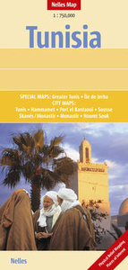
Tunisia Nelles Map
Description of the previous edition: Tunisia at 1:750, 000 from Nelles Verlag, with a smaller size sheet offering a convenient format for use when travelling. The whole of the reverse side is used for street plans and enlargements of the most visited areas.On one side is a road map of Tunisia, with the country’s southernmost tip shown as an inset. Topography is presented by vivid relief shading, with numerous spot and names of mountain ranges or deserts. Salt pans and seasonal rivers and lakes are marked, as well as oasis and wells or watering points. National parks and other protected area are highlighted. Road network includes partially paved roads and cart tracks, with distances shown on main routes. Railway lines and local airports are included, and the map also shows internal
administrative boundaries with names of the provinces, plus pipelines. Numerous places of interest are prominently marked. Latitude and longitude margin ticks are at 1° intervals. The map has no index of localities. Map legend includes English.The whole of the reverse side is used to present numerous street plans and enlargements, all highlighting places of interest. A large street plan at 1:11, 000 presents Tunis, with coverage extending well beyond its Medina and Ville Nouvelle districts. A separate road map covers the city’s environs, including access to the international airport, the archaeological site at Carthage and the beaches.Also included is an enlargement of Île de Djerba with a street plan of Houmt Souk, plus street plans of Hammamet, Port El Kantaoui, Monastir with
the Skanès-Monastir holiday resort, and Sousse with an enlargement for its Medina.

Product Description
Reviews/Comments
Add New
Intelligent Comparison
Archived Product
Afghanistan Nelles Map Stanfords
£7.95
Archived Product
Tunis IGN Map Stanfords
£11.99
Vouchers
No voucher codes found.
Do you know a voucher code for this product or supplier? Add it to Insights for others to use.
Do you know a voucher code for this product or supplier? Add it to Insights for others to use.
 Denmark