
 United Kingdom
 France
 Germany
 Netherlands
 Sweden
 USA
USA
 Italy
Italy
 Spain
Spain
More From Contributor


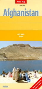
Afghanistan Nelles Map
Afghanistan at 1:1, 500, 000 from Nelles Verlag, with its smaller size, double-sided map offering a convenient format for use when travelling. The map includes a street plan of Kabul and provides coverage of the adjoining areas of Pakistan and most of Tajikistan.The country is divided north/south, with both sides including Kabul and a generous overlap for the central region. Vivid relief shading with spot heights and names of mountain ranges presents the topography. Road network distinguishes between partially paved roads and cart tracks, and shows distances on main routes. Railway lines and local airports are included and the map also shows internal administrative boundaries with names of the provinces.Various places of interest, both in Afghanistan and in the adjoining countries,
are prominently marked. Latitude and longitude margin ticks are at 1° intervals. The map has no index of localities. Map legend includes English.Also provided is an inset with a street plan of central Kabul indicating various facilities, selected foreign embassies, places of interest, etc.
are prominently marked. Latitude and longitude margin ticks are at 1° intervals. The map has no index of localities. Map legend includes English.Also provided is an inset with a street plan of central Kabul indicating various facilities, selected foreign embassies, places of interest, etc.

Product Description
Reviews/Comments
Add New
Intelligent Comparison
Archived Product
Afghanistan Wall Map Stanfords
£19.95
Archived Product
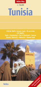
Tunisia Nelles Map Stanfords
£7.95
Archived Product

Pakistan Nelles Stanfords
£10.99
Vouchers
No voucher codes found.
Do you know a voucher code for this product or supplier? Add it to Insights for others to use.
Do you know a voucher code for this product or supplier? Add it to Insights for others to use.
 Denmark