More From Contributor
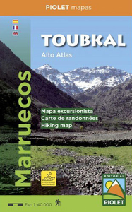
£3.50
Tottenham in 1936 in a fascinating series of reproductions of old Ordnance Survey plans in the Alan Godfrey Editions, ideal for anyone interested in the history of their neighbourhood or family. Two versions have been published to cover this area of the southern half of Tottenham, stretching from South Tottenham station northward to Bruce Grove station, & from Abbotsford Avenue eastward to the GER railway. Features include Seven Sisters station, West Green station, Tottenham Hale, Page Green, St Ann`s, Tottenham brewery, tramways, The Green, General Hospital, Clyde Circus, Downhills Park & Tottenham High School. The 1936 map shows several industrial sites at Tottenham Hale, including cabinet works, shoe factories & Basildon stationery works. About the Alan Godfrey Editions of the 25” OS Series: Selected towns in Great Britain & Ireland are covered by maps showing the extent of urban development in the last decades of the 19th & early 20th century. The plans have been taken from the Ordnance Survey mapping & reprinted at about 15 inches to one mile (1:4, 340). On the reverse most maps have historical notes & many also include extracts from contemporary directories. Most maps cover about one mile (1.6kms) north/south, one & a half miles (2.4kms) across; adjoining sheets can be combined to provide wider coverage.FOR MORE INFORMATION & A COMPLETE LIST OF ALL AVAILABLE TITLES PLEASE CLICK ON THE SERIES LINK. ...
Archived Product
£10.00
Totterdown Rising is a book about a community that was split in half to make way for a road that was never built. But it's not a book about a community beaten into submission by a local council's obsession with the motor car, it's a story of how people rebuilt their community & reinvented the very special Spirit of Totterdown. But there is more to the story than a tale of a resurgent community. Kate Pollard's detailed research has uncovered some alarming facts about the role of the City Council in the demolition of Totterdown. It appears that the detailed plans to knock down an entire community, shops & pubs was never voted on & that the council pressed ahead with the demolition before they had received Government backing for the Road plan. In the course of researching this book, Kate Pollard also discovered that many of the houses that were demolished to make way for the Outer Circuit Road were the subject of compulsory purchase orders. In the case of a number of houses, the owners were absent & were not found within the timetable of the demolition process. In case they reappeared at a later date to discover their houses had gone, in around 1970 the Council lodged a fund in the Unclaimed Balances section of the Chancery Courts in London so that some compensation could be administered to them. Through painstaking research, Kate Pollard has tracked down that money & discovered that the unclaimed balance of it should have been reclaimed by Bristol City Council many years ago. In July 2006, Bristol City Council's Senior Solicitor (Corporate) confirmed that the money was still held at the Court Funds Office. At the time of going to print, investigations were continuing into the status of the fund. ...
Archived Product
£3.50
Totteridge in 1895 in a fascinating series of reproductions of old Ordnance Survey plans in the Alan Godfrey Editions, ideal for anyone interested in the history of their neighbourhood or family. The map covers the Middlesex village of Totteridge, spread out west-east from Totteridge Common to The Grange, Totteridge House & St Andrew`s church, & to the fringe of Totteridge Green. It is shown as a very rural village with just a scattering of house, including Copped Hall, one time home to Bulwer Lytton, with its extensive grounds. St Edward`s School, opened in the 1880s as an orphanage for RC children, is at the left side of the map. On the reverse, by contrast, is over half of the later 1935 revision, showing Totteridge at a more built-up stage. About the Alan Godfrey Editions of the 25” OS Series: Selected towns in Great Britain & Ireland are covered by maps showing the extent of urban development in the last decades of the 19th & early 20th century. The plans have been taken from the Ordnance Survey mapping & reprinted at about 15 inches to one mile (1:4, 340). On the reverse most maps have historical notes & many also include extracts from contemporary directories. Most maps cover about one mile (1.6kms) north/south, one & a half miles (2.4kms) across; adjoining sheets can be combined to provide wider coverage.FOR MORE INFORMATION & A COMPLETE LIST OF ALL AVAILABLE TITLES PLEASE CLICK ON THE SERIES LINK. ...
Archived Product
£2.95
Tottington in 1908 in a fascinating series of reproductions of old Ordnance Survey plans in the Alan Godfrey Editions, ideal for anyone interested in the history of their neighbourhood or family. Selected towns in Great Britain & Ireland are covered by maps showing the extent of urban development in the last decades of the 19th & early 20th century. In this title: the map covers part of Tottington & links up with the group of Bury maps. The River Irwell runs up the east side of the map, with a section of the LYR railway, including Olive's Siding. On the west side of the map is the company's Tottington Branch, with Tottington & Green Mount stations. Part of Tottington village is shown, including St Anne's church, Spring Mill, St John's church, Old Doctors, Quakers Field, Stormer Hill Bleach Works. Other features include Kirklees Mill, Kirklees, Tottington Mill, Knowles Siding, Green Mount, Brandlesholme Hall Farm, Brandlsholme New Hall, Wood Road. On the reverse is a 1918 directory of Tottington, plus a 1914 railway timetable for the Bury to Holcombe Brook line. About the Alan Godfrey Editions of the 25 ...
Archived Product
£3.50
Tottington in 1908 in a fascinating series of reproductions of old Ordnance Survey plans in the Alan Godfrey Editions, ideal for anyone interested in the history of their neighbourhood or family. The map covers part of Tottington & links up with the group of Bury maps. The River Irwell runs up the east side of the map, with a section of the LYR railway including Olive`s Siding. On the west side of the map is the company`s Tottington Branch, with Tottington & Green Mount stations. Part of Tottington village is shown, including St Anne`s church, Spring Mill, St John`s church, Old Doctors, Quakers Field, Stormer Hill Bleach Works. Other features include Kirklees Mill, Kirklees, Tottington Mill, Knowles Siding, Green Mount, Brandlesholme Hall Farm, Brandlsholme New Hall, Wood Road, etc. On the reverse is a 1918 directory of Tottington, plus a 1914 railway timetable for the Bury to Holcombe Brook line. * About the Alan Godfrey Editions of the 25” OS Series: Selected towns in Great Britain & Ireland are covered by maps showing the extent of urban development in the last decades of the 19th & early 20th century. The plans have been taken from the Ordnance Survey mapping & reprinted at about 15 inches to one mile (1:4, 340). On the reverse most maps have historical notes & many also include extracts from contemporary directories. Most maps cover about one mile (1.6kms) north/south, one & a half miles (2.4kms) across; adjoining sheets can be combined to provide wider coverage.FOR MORE INFORMATION & A COMPLETE LIST OF ALL AVAILABLE TITLES PLEASE CLICK ON THE SERIES LINK. ...
Archived Product
£12.99
Jbel Toubkal & the surrounding area on a hiking map at 1:50, 000, with on the reverse a detailed street plan of central Marrakesh, including its Medina, printed on light, waterproof & treat-resistant synthetic paper. On one side is a detailed topographic map at 1:50, 000 centred on the village of Imelil, about 8km north of Toubkal, covering an area of 32kms east/west by 22kms north/south. Topographic information

Includes::
contours at 20m intervals, hill-shading, woodland & scrub areas, springs, creeks, rivers & dry riverbeds. The map shows local roads, tracks & footpaths. Funicular railways & ski-lifts are also marked. Symbols indicate locations of campsites & refuges, ski-stations, & religious buildings. The map has a 1km UTM grid & margin ticks at 5’ intervals. On the reverse is a clear plan of central Marrakech at Approx. 1:8, 700. It covers the Medina district & extends westwards to the main railway terminus. Colours highlight main sites of interest, public buildings, shopping areas/markets & pedestrian zones. One-way streets are marked & symbols show a range of useful features e.g. selected, hotels, taxi ranks, car parks, information offices, petrol stations, public water fountains, places of worship, etc.

...
Archived Product
£10.00
Toubkal Massif in a series of GPS compatible maps at 1:160, 000 published by EWP & West Col Productions & covering Morocco’s Atlas Mountains with its neighbouring deserts & coastal areas. The maps use the cartography of the Russian military survey of the area, providing a very detailed representation of the terrain, with contours at 40m intervals plus graphics and/or colouring to show features such as cliffs, ravines, sand ridges & dunes, various types of vegetation, etc. All place names are given in the Latin alphabet. Road information

Includes::
unsurfaced roads & tracks. Where main roads meet the edge of the map, the distance to the next large town is stated. Selected high passes are annotated to show months when passable. Railways & local airports are marked & a range of symbols indicate various landmarks & places of interest, including mountain refuges & forestry buildings, oasis, caves, etc. Interesting locations are highlighted. Each sheet covers 40’ of latitude & 1° of longitude & has a grid based on the Kronstadt system which, according to the publishers’ notes, is related closely to the UTM system & is suitable for a GPS set to UTM or MGRS. The maps also have either additional margin ticks or a grid for latitude & longitude. On the reverse are illustrated notes about the area, plus a glossary of Berber terms & notes on transliteration of local names. Map legend & all the texts are in English & French.

...
Archived Product
£4.99
Teach your child all about animal families in ” Touch & Feel: Baby Animals”. Twinkly, bumpy, scaly, silky, sandy, sticky & shiny textures in a chunky package will help your child discover all about baby animals. From soft rabbits to tiny chicks. Let their little hands roam & feel how smooth & velvety the calves are, but how rough the baby elephant`s ears feel. Read it together
- they`ll learn as you play. These Touch & Feel chunky padded board books will help encourage your child`s early learning & language. This is perfect for encouraging tiny fingers to explore & great for sensory development.
...
Archived Product
£4.99
Teach your child all about farms with touch & feel textures in this chunky board book. Twinkly, bumpy, scaly, silky, sandy, sticky & shiny textures in a chunky package will help your child discover all about farms. Oink oink! Quack quack! Let their little hands roam & feel how velvety the pigs nose is & how fluffy the chicks feel. Read it together
- they`ll learn as you play. These Touch & Feel chunky padded board books will help encourage your child`s early learning & language. It is perfect for encouraging tiny fingers to explore & great for sensory development.
...
Archived Product
£4.99
Introduce your child to fire-fighting heroes in Touch & Feel: Fire Engine. Twinkly, bumpy, hard, soft, silky & shiny touch & feel textures in a chunky package will help your child learn all about puppies. How scratchy is the engine grille? Can you see the fire man? From rubbery tyres to shiny bumpers, let their little hands roam & discover all about Fire Engines. Read it together
- they'll learn as you play. These Touch & Feel chunky padded board books will help encourage your child's early learning & language. It is perfect for encouraging tiny fingers to explore & great for sensory development.
...
Archived Product

Toubkal

Jbel Toubkal and the surrounding area around Oukaà meden and Imlil on a detailed, GPS compatible, contoured map at 1:40, 000 from Editorial Piolet printed on light, waterproof and tear-resistant plastic paper.Contours at 20m intervals with bold relief shading present the topography. The map shows local roads, track and trails, including the ascent routes to the peaks. Symbols mark locations of refuges, hotels and gîtes d’etape, information centres and medical assistance facilities, ski and climbing areas, rock paintings, etc. The map has a UTM grid. Map legend and accompanying text include English.
RIP - This product is no longer available on our network. It was last seen on 25.09.2019

This page now acts as a permanent archive for this product. Add more information using the comments box below to ensure it can still be found by future generations.

Use our search facility to see if it is available from an alternative contributor.
  • External links may include paid for promotion
  • Availability: Out Of Stock
  • Supplier: Stanfords
  • SKU: 9788494708022
Availability: In Stock
£14.99

Product Description

Jbel Toubkal & the surrounding area around Oukaà meden & Imlil on a detailed, GPS compatible, contoured map at 1:40, 000 from Editorial Piolet printed on light, waterproof & tear-resistant plastic paper. Contours at 20m intervals with bold relief shading present the topography. The map shows local roads, track & trails, including the ascent routes to the peaks. Symbols mark locations of refuges, hotels & gîtes d’etape, information centres & medical assistance facilities, ski & climbing areas, rock paintings, etc. The map has a UTM grid. Map legend & accompanying text include English.

Reviews/Comments

Add New

Intelligent Comparison

Oooops!
We couldn't find anything!
Perhaps this product's unique.... Or perhaps we are still looking for comparisons!
Click to bump this page and we'll hurry up.

Price History

Vouchers

No voucher codes found.
Do you know a voucher code for this product or supplier? Add it to Insights for others to use.

Facebook

Jargon Buster

GPS - Global Positioning System - Global position using satellites
Paper - A thin sheet mainly used for writing. Available in a variety of colours. Made mainly from wood pulp.
Plastic - A generic term for a synthetic product used in the manufacture of products
Waterproof - Resistant to water, usualy specified by depth in metres
Resistant - Something that can repel against something.

Supplier Information

Stanfords
Stanfords was established in 1853 and opened their iconic Covent Garden flagship store in 1901. They have become the top retailer of maps, travel books and accessories in the UK and arguably offer the largest selection of maps and travel books worldwide. Famous names such as Captain Robert Falcon Scott, Ranulph Fiennes and Michael Palin have purchased from Stanfords. They now have a shop in Bristol and both stores together with other venues operate a calendar of events including talks, book signings and exhibitions. As a specialist map retailer, the map selection is comprehensive and includes road maps, street maps and walking maps from worldwide destinations, as well as a selection of world atlases and wall maps. Books include travel guides and travel literature. Stanfords also stock globes, from miniatures made of blue marble to magnificent floor-standing globes. The website features a selection of interesting articles on travel topics.
Page Updated: 2023-11-12 20:15:36

Community Generated Product Tags

Oh No! The productWIKI community hasn't generated any tags for this product yet!
Menu