
 United Kingdom
 France
 Germany
 Netherlands
 Sweden
 USA
USA
 Italy
Italy
 Spain
Spain
More From Contributor

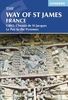


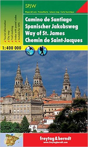
The Way Of St James F&B SPJW
The Way of St. James, Camino de Santiago routes across northern Spain highlighted on a large, double-sided road map at 1:400, 000 from Freytag & Berndt. The map shows the main Camino Francés route across the Pyrenees, Pamplona, Burgos and León, the coastal route across Donostia/San Sebastian and Bilbao, plus numerous variants linking them, as well as routes to Santiago from the coast at Ferrol or Cape Finisterre, from Portugal, etc. Both crossings of the Pyrenees are marked, via Roncesvalles or through Col du Somport, and coverage extends south to Segovia, Zamora and Porto, so the map also shows the northern part of the Vía de la Plata. On all the routes traditional stopover places are highlighted.The map shows the region’s road and rail networks on a base with relief
shading and plenty of names of local sierras. National parks and other protected areas are clearly marked. Road network indicates scenic routes, seasonal closures, steep gradients, toll sections, motorway services, etc. Latitude and longitude grid is at intervals of 30’. Map legend includes English.A separate 87-page booklet has an extensive index, a street plan of Santiago de Compostela, plus multilingual notes on main towns and various other aspects of the Way of St. James. The text includes English.
shading and plenty of names of local sierras. National parks and other protected areas are clearly marked. Road network indicates scenic routes, seasonal closures, steep gradients, toll sections, motorway services, etc. Latitude and longitude grid is at intervals of 30’. Map legend includes English.A separate 87-page booklet has an extensive index, a street plan of Santiago de Compostela, plus multilingual notes on main towns and various other aspects of the Way of St. James. The text includes English.

Product Description
Reviews/Comments
Add New
Vouchers
No voucher codes found.
Do you know a voucher code for this product or supplier? Add it to Insights for others to use.
Do you know a voucher code for this product or supplier? Add it to Insights for others to use.
 Denmark