More From Contributor
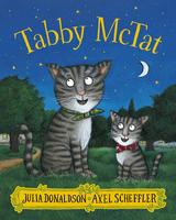
£8.99
Ten years on from Trainspotting, Simon ` Sick Boy` Williamson is back in Edinburgh after a long spell in London. Having failed spectacularly as a hustler, pimp, husb&, father & businessman, Sick Boy taps into an opportunity, which to him represents one last throw of the dice. However, to realise his dream of directing & producing a pornographic movie, Sick Boy must team up with old pal & fellow exile Mark Renton & a motley crew that

Includes::
the city`s favourite ex-aerated-water-salesman, ` Juice` Terry Lawson. In the world of Porno, however, nothing is straightforward, as Sick Boy & Renton find out that they have unresolved issues to address, concerning the increasingly unhinged Frank Begbie, the troubled, drug-addled Spud, but, most of all, with each other.

...
Archived Product
£6.95
Topographic coverage of mainland Spain at 1:50, 000 in the MTN50 (Mapa Topográfico Nacional) series from the Centro Nacional de Información Geografica, the country’s civilian survey organization. The maps have contours at 20m intervals, enhanced by relief shading, plus colouring and/or graphics to show different types of terrain, vegetation or land use. Boundaries of national parks & other protected areas are marked. In addition to all the usual information featured on topographic mapping at this scale, detailed presentation of the road & rail networks, rural tracks & paths, etc, the maps also show campsites & mountain refuges. On more recent editions some GRs, the official long-distance hiking routes, are also marked (although not as clearly as on hiking maps from other publishers). Each map covers 29.5x 18.5 km (with adjustments in the border or coastal areas). The maps have a 1-km UTM grid, plus margin ticks for latitude & longitude at 1` intervals. Map legend is in Spanish only.HOW TO CHOOSE THE RIGHT 50K MAP: all the titles in CNIG’s 200K Provincial Road Maps series at 1:200, 000 are overprinted with the grid for the 1:50, 000 maps & can be used to see the area covered by each 50K title. TO SEE THE LIST OF TITLES IN THIS SERIES PLEASE CLICK ON THE SERIES LINK.PLEASE NOTE
- MAP TITLES: the grids shown on our website serve both the civilian & the military 1:50, 000 topographic series. Although the areas covered by maps in both series are identical (apart from some border or coastal sheets), occasionally map titles differ – only one title is shown on the grid, usually the military one. In Galicia, the Basque country & in the Catalan speaking areas the tendency now is to use local place names rather than the often better known Castilian ones. Where possible, both versions are included in our titles. Map titles listed on our website are based on information received by us at the time of publication, but sometimes maps arrive showing a completely different title! As long as the map number is as ordered, the correct map has been supplied.
...
Archived Product
£10.50
One of the titles in a series of road maps of the administrative states of Mexico, highlighting places of interest. The maps show four different grades of roads, with intermediate driving distances on main routes, railways, local airports, ferry connections & administrative boundaries. Topographic information is limited to names of main mountain ranges, spot heights for main peaks, rivers & lakes. The maps have no geographical coordinates. Map legend is in Spanish only. On the reverse each title has a black & white version of the same map, highlighting places of interest with brief notes in Spanish only. ...
Archived Product
£12.99
One of the titles in a series of road maps of the administrative states of Mexico, highlighting places of interest. The maps show four different grades of roads, with intermediate driving distances on main routes, railways, local airports, ferry connections & administrative boundaries. Topographic information is limited to names of main mountain ranges, spot heights for main peaks, rivers & lakes. The maps have no geographical coordinates. Map legend is in Spanish only. On the reverse each title has a black & white version of the same map, highlighting places of interest with brief notes in Spanish only. ...
Archived Product
£13.99
Road maps of Mexico’s states from Ediciones Independencia highlighting numerous places of interest & tourist facilities, with each title also providing a large street plan of the provincial capital plus maps of other local towns, popular tourist resorts and/or archaeological sites. The state maps show the road & rail networks on a clear base, with topography indicated by rivers & areas liable to inundation, plus names of main mountain ranges & peaks (no heights). National parks & other protected areas are brightly highlighted. A range of symbols provides information for tourists: accommodation including campsites & trailer parks, historical & archaeological sites, beaches & spas, sport & leisure centres, natural curiosities, etc. The maps show latitude & longitude as margin ticks & crosshairs, mostly at 30’ or 1° intervals. Map legend

Includes::
English. Most maps have no index. Each title

Includes::
a large street plan of the provincial capital, plus plans of selected other towns. In addition to street names, the plans also show names of local districts. Plans of the state capital usually have a list of various locations, facilities and/or places on interest highlighted on it, & some include an enlargement showing the town centre in greater detail. Each title also has a table of distances, plus a table showing various facilities & places of interest in the main towns of the state.


...
Archived Product
£6.99
Tabby Mc Tat loves singing along with Fred the busker, as people throw coins in their hat. But when Fred has an accident, the two are separated. Will they ever find each other again? Tabby Mc Tat`s story has captured the imagination of hundreds of thousands of children. It is now available in sturdy board book format, perfect for Tabby Mc Tat`s youngest fans. Praise for Tabby Mc Tat: ` Absolutely purr-fect stuff` The Times ` Our five-year-old gave it the thumbs up, & that`s about the best endorsement you can get` News of the World ...
Archived Product
£6.95
Topographic coverage of mainland Spain at 1:50, 000 in the MTN50 (Mapa Topográfico Nacional) series from the Centro Nacional de Información Geografica, the country’s civilian survey organization. The maps have contours at 20m intervals, enhanced by relief shading, plus colouring and/or graphics to show different types of terrain, vegetation or land use. Boundaries of national parks & other protected areas are marked. In addition to all the usual information featured on topographic mapping at this scale, detailed presentation of the road & rail networks, rural tracks & paths, etc, the maps also show campsites & mountain refuges. On more recent editions some GRs, the official long-distance hiking routes, are also marked (although not as clearly as on hiking maps from other publishers). Each map covers 29.5x 18.5 km (with adjustments in the border or coastal areas). The maps have a 1-km UTM grid, plus margin ticks for latitude & longitude at 1` intervals. Map legend is in Spanish only.HOW TO CHOOSE THE RIGHT 50K MAP: all the titles in CNIG’s 200K Provincial Road Maps series at 1:200, 000 are overprinted with the grid for the 1:50, 000 maps & can be used to see the area covered by each 50K title. TO SEE THE LIST OF TITLES IN THIS SERIES PLEASE CLICK ON THE SERIES LINK.PLEASE NOTE
- MAP TITLES: the grids shown on our website serve both the civilian & the military 1:50, 000 topographic series. Although the areas covered by maps in both series are identical (apart from some border or coastal sheets), occasionally map titles differ – only one title is shown on the grid, usually the military one. In Galicia, the Basque country & in the Catalan speaking areas the tendency now is to use local place names rather than the often better known Castilian ones. Where possible, both versions are included in our titles. Map titles listed on our website are based on information received by us at the time of publication, but sometimes maps arrive showing a completely different title! As long as the map number is as ordered, the correct map has been supplied.
...
Archived Product
£6.50
Topographic coverage of mainland Spain at 1:25, 000 published by the Centro Nacional de Información Geograficá, the country’s civilian survey organization. The maps have contours at 10m intervals & colouring and/or graphics to show different types of vegetation or land use. Boundaries of national parks & other protected areas are marked. In addition to all the usual information shown on topographic maps at this scale, detailed presentation of the road & rail networks, rural tracks & paths, etc, the maps also show campsites. The maps have a 1-km UTM grid, with margin ticks for latitude & longitude at 1` intervals. Map legend is in Spanish only.PLEASE NOTE: our grid for the whole of Spain is in preparation
- in the meantime, for areas other than those shown on the attached grid please use CNIG’s topographic survey at 1:50, 000 by searching for ‘SI00000832’. Each 25K map covers one quarter of the corresponding 50K map, with the numbering system: I = NW quarter, II = NE quarter, III = SW quarter & IV = SE quarter. CNIG maps in the Provincial Road Maps series at 1:200, 000 are overprinted with the grid for the 1:50, 000 survey & can be used to see the area covered by each 50K or 25K title in more detail. To see the list of titles in this series please click on the series grid
- for map numbers not yet listed on our website please contact us by email.

...
Archived Product
£12.95
Table Mountain on an A2-size, waterproof & tear-resistant map from Slingsby Maps, with details of 23 hiking routes. Contour lines are drawn at 10m intervals, with several different types of vegetation & terrain indicated on the map, e.g. renosterveld/grassl&, different kinds of fynbos, marshes, plantations, gum belts, etc. Boundaries of the Table Mountain National Park & of the restricted Orange Kloof area are marked. Road network

Includes::
untarred public roads, private roads indicating access open to pedestrians or mountain bikers, signposts, parking areas, etc. Footpaths are clearly shown, including dangerous or restricted access sections, & the Table Mountain Challenge Route. Extensive overprint highlights other places of interest, picnic areas, benches & natural shelters, restaurants & drinking water, recreational facilities, etc. Both UTM grid lines at 200m & latitude/longitude lines at 1

...
Archived Product

Tabby McTat

Tabby McTat is purr-fectly happy, singing along all day with Fred the busker. But when Fred gives chase to a thief, the two are separated. Will they ever find each other again? A heart-warming story of friendship, loyalty - and kittens! `Our five-year-old gave it the thumbs up, and that`s about the best endorsement you can get.` News of the World
RIP - This product is no longer available on our network. It was last seen on 25.09.2019

This page now acts as a permanent archive for this product. Add more information using the comments box below to ensure it can still be found by future generations.

Use our search facility to see if it is available from an alternative contributor.
  • External links may include paid for promotion
  • Availability: Out Of Stock
  • Supplier: Stanfords
  • SKU: 9781407170701
Availability: In Stock
£6.99

Product Description

Tabby Mc Tat is purr-fectly happy, singing along all day with Fred the busker. But when Fred gives chase to a thief, the two are separated. Will they ever find each other again? A heart-warming story of friendship, loyalty
- & kittens! ` Our five-year-old gave it the thumbs up, & that`s about the best endorsement you can get.` News of the World

Reviews/Comments

Add New

Intelligent Comparison

Oooops!
We couldn't find anything!
Perhaps this product's unique.... Or perhaps we are still looking for comparisons!
Click to bump this page and we'll hurry up.

Price History

Vouchers

No voucher codes found.
Do you know a voucher code for this product or supplier? Add it to Insights for others to use.

Facebook

Jargon Buster

Thumbs - Found on each hand. The first digit.
World - A physical grouping, commonly used to describe earth and everything associated with ti
Day - The time it takes a planet or other space objects to complete one rotation.
Year - The time it takes the planet earth to orbit the sun. This takes around 365.25 days.
Heart - An organ that pumps blood around the body. Usually related to love.
Year - 365 days (366 days in a leap year), the time taken for planet earth to make one full revolution around the sun.

Supplier Information

Stanfords
Stanfords was established in 1853 and opened their iconic Covent Garden flagship store in 1901. They have become the top retailer of maps, travel books and accessories in the UK and arguably offer the largest selection of maps and travel books worldwide. Famous names such as Captain Robert Falcon Scott, Ranulph Fiennes and Michael Palin have purchased from Stanfords. They now have a shop in Bristol and both stores together with other venues operate a calendar of events including talks, book signings and exhibitions. As a specialist map retailer, the map selection is comprehensive and includes road maps, street maps and walking maps from worldwide destinations, as well as a selection of world atlases and wall maps. Books include travel guides and travel literature. Stanfords also stock globes, from miniatures made of blue marble to magnificent floor-standing globes. The website features a selection of interesting articles on travel topics.
Page Updated: 2023-11-12 20:15:36

Community Generated Product Tags

Oh No! The productWIKI community hasn't generated any tags for this product yet!
Menu