
 United Kingdom
 France
 Germany
 Netherlands
 Sweden
 USA
USA
 Italy
Italy
 Spain
Spain
More From Contributor


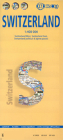
Switzerland Borch
Laminated and waterproof, double-sided, indexed road map of Switzerland, with an inset showing the cantons. Relief shading with names of Alpine ranges and numerous peaks with heights shows the country’s topography. Mountain passes indicate seasonal closures. Road network shows roads closed to motorized traffic, tolls and motorway services. Railways and ferry connections on the main lakes are marked (although the railway lines are not always easy to see against the background). The map highlights town and villages worth visiting and various interesting sights. No geographical coordinates are provided. Also included is an administrative map showing the division of Switzerland into cantons and information on the country’s climate. Multilingual map legend includes English.

Product Description
Reviews/Comments
Add New
Vouchers
No voucher codes found.
Do you know a voucher code for this product or supplier? Add it to Insights for others to use.
Do you know a voucher code for this product or supplier? Add it to Insights for others to use.
 Denmark