More From Contributor
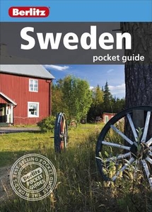
£9.99
Sweden at 1:900, 000 on an indexed, double-sided map from ITMB showing its network of roads & main railway lines on a base with altitude colouring to indicate the topography, plus highlighting for main places of interest. Latitude & longitude lines are drawn at 1º & 2º intervals respectively. Each side has a separate index. Also included is a street plan of Stockholm’s historic Gamla Stan district, highlighting its sights & selected accommodation. ...
Archived Product
£6.99
Sweden at 1:800, 000 on a large, double-sided road map from Marco Polo Travel Publishing with prominent highlighting of interesting locations, enlargements for the environs of Stockholm & Gothenburg, plus an index booklet with 5 city maps & brief descriptions of 15 selected top sights, etc. Sweden is divided between the two sides of the map with a generous overlap & coverage

Includes::
the whole of Norway & Denmark, extending south to Hamburg & the Baltic coast of Germany. Cartography is from the renowned German publishers Mair Dumont. Road network

Includes::
minor roads, highlights scenic roads & special tourist routes, shows intermediate driving distances on main roads, & indicates motorway services, toll stations, caravan & vehicle restrictions, seasonal closures of mountain roads, etc. Railway lines & local airports are included, as well as administrative divisions with names of the provinces. Locations of interest are highlighted, with separate colouring for towns or villages & for natural sites; 15 most interesting sights are cross-referenced to their descriptions in a booklet attached to the map cover. Symbols show locations of campsites, youth hostels, etc. National parks & other protected areas are marked & topography is presented by relief shading with plenty of names of mountain ranges, valleys, etc. Latitude & longitude lines are drawn at 1º intervals. The index is in the booklet. Enlargements show in greater detail the environs of Stockholm & Gothenburg & the booklet also provides street plans of town centres in these two cities plus in Malmö, Helsingborg & Uppsala, plus lists of airports, UNESCO World Heritage sites, & amusement parks. Multilingual map legend & all the text include English.A fold-out flap in the cover shows for route planning an overview of the whole area covered by the map plus the adjacent regions, prominently highlighting main places of interest, with the grid reference system in the margins making it easier to find locations on the main map. Also included are a distance/driving times table & basic driving regulations.


...
Archived Product
£5.99
The Michelin National road map of Sweden at 1:1, 200, 000 scale is ideal for route planning. The map gives comprehensive coverage of national road networks showing all major motorways, dual carriageways, national & regional main roads & some single-lane roads. Also shows unsurfaced roads & tracks & major footpaths. The map is divided by grid showing latitude & longitude. Distances between major locations are marked along roads, with total distance & several intermediate distances shown. A quick-reference chart of distances & driving times between major locations is also included. The map also

Includes::
a grid-referenced index of principal place names. Clear, easy-to read cartography shows roads in reds, yellows & white with black outlines. Major topography is indicated with relief shading. Woodland & forest is marked with green shading. Built-up urban areas are clearly marked in yellow. Airports, ferries, railways are also marked. National divisions are marked. Places of interest Also

Includes::
a quick reference panel giving national driving regulations, including speed limits, equipment requirements (e.g. bulb kits, warning triangles) & seatbelt rules. Town plans & regional enlargements:- Stockholm at 1:300, 000 scale- Gothenburg at 1:300, 000 scale- Malmo at 1:300, 000 scale


...
Archived Product
£10.99
Sweden North: -stersund area in a series of detailed, indexed touring maps from Freytag & Berndt with the southern & central part of the country at 1:250, 000 & the north at 1:400, 000. Relief shading & spot heights show the topography. Road network

Includes::
what is confusingly described in the map legend as “private” roads, unsurfaced roads open to the general public but simply privately maintained, & indicates toll routes, restrictions & winter closures, steep gradients, motorway services, etc. Scenic roads & special tourist routes are highlighted. Railways with stations, ferry services, & local administrative boundaries are marked. National parks & prohibited areas are highlighted & symbols show places of interest, campsites, mountain shelters, youth hostels, etc. The maps of southern & central Sweden have latitude & longitude lines drawn at 10` intervals, with 30` on the two northern sheets. Multilingual map legend

Includes::
English. A place name index, with post codes, is provided in a booklet attached to the map cover.


...
Archived Product
£4.99
Sweden in the Pocket Guide series from Berlitz; a collection of handy, pocket-sized guides dedicated to an extensive range of cities, regions & countries worldwide. Written in narrative form, individual guides explore the history, main sights & attractions, food & drink, accommodation & local culture of the destination in detail. Each Berlitz pocket guide has a similar format, with colour-coded sections helping readers locate information quickly in addition to distinctive chapters exploring the city or region. An introduction outlines the destination for visitors & a section dedicated to 'A Brief History' actually explores the area in relative depth. A where to go chapter is organized by region & city & is written in prose form with references to individual sites highlighted in bold for clarity. There are also further suggestions on where & when to eat. Recommendations for leisure activities in the region, including sport, nightlife & shopping, are also provided & tailored accordingly for each destination. Handy travel tips are listed alphabetically in a dedicated section, providing practical guidance & helping visitors make the most of their stay. The main hotels, particularly for cities, are also listed in an accommodation section, offering a brief overview with approximate price bandings & relevant contact details. ...
Archived Product
£5.99
Berlitz Pocket Guide Sweden is a concise, full-colour travel guide to this enchanting Scandinavian country, combining inspiring photography with insider tricks & tips to help you uncover the best of Sweden. It tells you everything you need to know about the best places to visit in Sweden, from the beautiful capital, Stockholm, & the lively cities of Gothenburg & Malmo to the verdant forests of the Central Heartlands & the remote landscapes of Norrl&. Handy maps on the cover flaps help you find your way, & are cross-referenced to the text. To inspire you, the book offers a rundown of the 10 top attractions in Sweden, followed by an itinerary for a Perfect Tour. The What to Do chapter is a snapshot of things to do in Sweden, including sports, shopping, entertainment & activities for children. The book provides all the essential background on Sweden's culture, including a brief history of Sweden & an Eating Out chapter covering the national cuisine. There are carefully chosen listings of the best hotels & restaurants & an A-Z of all the practical information you'll need. ...
Archived Product
£4.99
A brand new edition of our sheet map showing the whole of Sweden at 16 miles to 1 inch (1 cm to 10 km). The map has been specifically prepared for long-distance travel, picking out major routes & destinations in bold colours for easy journey planning & route finding, &

Includes::
town plans & a comprehensive index. The map is a convenient size for using in the vehicle. The digital mapping gives excellent clarity, showing road networks in exceptional detail. Town plans & approach maps are provided for, plus an approach map of Malmo. High quality travel information

Includes::
a wealth of useful detail marking car ferries, airports, national parks, churches, camping sites, youth hostels, castles, golf courses. The map also

Includes::
a distance table & information on driving regulations in Sweden.


...
Archived Product
£9.50
Southern Sweden at 1:500, 000 on an indexed, waterproof & tear-resistant road map with topographic & tourist information, published by Reise Know-How as part of their highly acclaimed World Mapping Project. The map is double-sided to provide the best balance between a good scale & a convenient size sheet. Coverage extends north beyond Stockholm & Uppsala to include the F ...
Archived Product
£10.99
Sweden South: Malmö
- Helsingsborg
- Kalmar area in a series of detailed, indexed touring maps from Freytag & Berndt with the

...
Archived Product
£11.50
Southern Sweden at 1:500, 000 on an indexed, waterproof & tear-resistant road map with topographic & tourist information, published by Reise Know-How as part of their highly acclaimed World Mapping Project. The map is double-sided to provide the best balance between a good scale & a convenient size sheet. Coverage extends north beyond Stockholm & Uppsala to include the Färnebofjärdens National Park, with Gothenburg conveniently shown on both sides of the map. Gotland is shown as an inset. Road & rail networks are easy to see on a clear base. Road network

Includes::
motorway, main & secondary roads as well as many selected local roads. Road numbers & distance markers in kilometres are given for main inert-city & cross-country routes. Railway lines & ferry routes are shown as are international & domestic airports. The map also shows internal administrative boundaries with names of the provinces. The map indicates various places of interest, including campsites, national parks, archaeological remains, UNESCO world heritage sites, notable viewpoints, etc. Latitude & longitude lines are drawn at 30’ intervals & the map is indexed. Map legend

Includes::
English.


...
Archived Product

Sweden Pocket Guide

Berlitz Pocket Guide Sweden is a concise, full-colour travel guide to this enchanting Scandinavian country, combining inspiring photography with insider tricks and tips to help you uncover the best of Sweden. It tells you everything you need to know about the best places to visit in Sweden, from the beautiful capital, Stockholm, and the lively cities of Gothenburg and Malmo to the verdant forests of the Central Heartlands and the remote landscapes of Norrland. Handy maps on the cover flaps help you find your way, and are cross-referenced to the text. To inspire you, the book offers a rundown of the 10 top attractions in Sweden, followed by an itinerary for a Perfect Tour. The What to Do chapter is a snapshot of things to do in Sweden, including sports, shopping, entertainment
and activities for children. The book provides all the essential background on Sweden`s culture, including a brief history of Sweden and an Eating Out chapter covering the national cuisine. There are carefully chosen listings of the best hotels and restaurants and an A-Z of all the practical information you`ll need.
RIP - This product is no longer available on our network. It was last seen on 25.09.2019

This page now acts as a permanent archive for this product. Add more information using the comments box below to ensure it can still be found by future generations.

Use our search facility to see if it is available from an alternative contributor.
  • External links may include paid for promotion
  • Availability: Out Of Stock
  • Supplier: Stanfords
  • SKU: 9781780048802
Availability: In Stock
£5.99

Product Description

Berlitz Pocket Guide Sweden is a concise, full-colour travel guide to this enchanting Scandinavian country, combining inspiring photography with insider tricks & tips to help you uncover the best of Sweden. It tells you everything you need to know about the best places to visit in Sweden, from the beautiful capital, Stockholm, & the lively cities of Gothenburg & Malmo to the verdant forests of the Central Heartlands & the remote landscapes of Norrl&. Handy maps on the cover flaps help you find your way, & are cross-referenced to the text. To inspire you, the book offers a rundown of the 10 top attractions in Sweden, followed by an itinerary for a Perfect Tour. The What to Do chapter is a snapshot of things to do in Sweden, including sports, shopping, entertainment & activities for children. The book provides all the essential background on Sweden`s culture, including a brief history of Sweden & an Eating Out chapter covering the national cuisine. There are carefully chosen listings of the best hotels & restaurants & an A-Z of all the practical information you`ll need.

Reviews/Comments

Add New

Intelligent Comparison

Oooops!
We couldn't find anything!
Perhaps this product's unique.... Or perhaps we are still looking for comparisons!
Click to bump this page and we'll hurry up.

Price History

Vouchers

No voucher codes found.
Do you know a voucher code for this product or supplier? Add it to Insights for others to use.

Facebook

Jargon Buster

History - Anything that happens in the past. An acedemic subject.
Entertainment - Something that provides amusement
Colour - The categorised spectrum of light visable to humans
Practical - Weather a task is easy to carry out and realistically succeed.
Pocket - A bag shaped insert in clothing used to carry items
Children - A young life form within the early stages of physical development,

Supplier Information

Stanfords
Stanfords was established in 1853 and opened their iconic Covent Garden flagship store in 1901. They have become the top retailer of maps, travel books and accessories in the UK and arguably offer the largest selection of maps and travel books worldwide. Famous names such as Captain Robert Falcon Scott, Ranulph Fiennes and Michael Palin have purchased from Stanfords. They now have a shop in Bristol and both stores together with other venues operate a calendar of events including talks, book signings and exhibitions. As a specialist map retailer, the map selection is comprehensive and includes road maps, street maps and walking maps from worldwide destinations, as well as a selection of world atlases and wall maps. Books include travel guides and travel literature. Stanfords also stock globes, from miniatures made of blue marble to magnificent floor-standing globes. The website features a selection of interesting articles on travel topics.
Page Updated: 2023-11-12 20:15:36

Community Generated Product Tags

Oh No! The productWIKI community hasn't generated any tags for this product yet!
Menu