More From Contributor

£3.99
The Lonely Planet Swahili Phrasebook is not only an extensive list of useful phrases, but also an ideal tool to start getting to grips with a language & beginning two-way communication. Containing excellent sections on language basics such as numbers, question phrases, dates, phrase construction, grammar & pronunciation, as well as containing concise but well-rounded two-way dictionaries, Lonely Planet phrasebooks enable you to quickly & confidently construct your own phrases in addition to those given. The given phrases cover all the essential travel & tourism categories such as transport, communications, business meetings & accommodation, as well as in-depth categories such as health, food & social interaction. The phrasebooks are designed to enable more than just simple question-answer communication, allowing the start of two-way conversations ...
Archived Product
£4.99
comprehensive food section, etiquette & cultural tips easy-to-use pronunciation guide sections include phrases for finding accommodation & for hitting the town useful suggestions for health needs & emergencies extensive two-way dictionary & user-friendly sentence builder Swahili is spoken in Tanzania, Uganda, Kenya, the Comoros & is the most widely spoken tribal language in East Africa Tanzania's reputation as a peaceful & secure destination combined with the fact that it has relaxed its entry formalities has contributed to its increased popularity as a tourist destination (source: WTO Tourism Market Trends 2003). Tanzania is the only country in Africa whose indigenous inhabitants include members of each of the continents four major ethno-linguistic families. Kenya's arrivals in 2004 have increased by 18 per cent & Uganda's has increased by 41 per cent ...
Archived Product
£14.99
The northernmost of the Yorkshire Dales, Swaledale can well claim to be the most beautiful; certainly to be the wildest & most romantic. It is, a local writer claimed `as close to Heaven as you get on Earth` & it has been celebrated by Yorkshiremen & others for over two hundred years. Stretching from the wilds around Muker & remote Arkengarthdale, through a landscape once scarred by lead mining, but now marked out by regular grey field walls & barns, & picturesque villages, to the splendour of Richmond with its great Medieval castle & its graceful eighteenth century bridge, theatre & houses, Swaledale is the classic Yorkshire dale, & here is a photographic portrait of it in all seasons & all weathers by a local photographer, ...
Archived Product
£7.99
John, Susan, Titty & Roger return to the lake for another summer camping on their island with their old allies, Nancy & Peggy, otherwise known as the Amazon pirates. But immediately disaster strikes when the Swallows find themselves marooned ashore by the shipwreck of their boat. But if they can`t have the isl&, there`s always Swallowdale, the secret valley, hidden from the world & containing an extra secret concealed within it. ...
Archived Product
£8.99
Wiola lives in a close-knit agricultural community. Wiola has a black cat called Blackie. Wiola`s father was a deserter but now he is a taxidermist. Wiola`s mother tells her that killing spiders brings on storms. Wiola must never enter the seamstress`s `secret` room. Wiola collects matchbox labels. Wiola is a good Catholic girl brought up with fables & nurtured on superstition. Wiola lives in a Poland that is both very recent & lost in time. Swallowing Mercury is about the ordinary passing of years filled with extraordinary days. In vivid prose filled with texture, colour & sound, it describes the adult world encroaching on the child`s. From childhood to adolescence, Wiola dances to the strange music of her own imagination. ...
Archived Product
£10.00
” An utter delight”
- Jennifer Tetlow. In the Encounters in the Wild series, renowned nature writer Jim Crumley gets up close
...
Archived Product
£12.99
`A completely fascinating novel & a marvellously skilful re-imagining of real people, times & places. Outstanding.`
- William
...
Archived Product
£11.00
This book was formerly available as one part of a two-volume set, detailing limestone cliff climbs in Dorset. This single volume is a reprint of the 1995 edition of Vol. 2, which covers covers Swanage to St Aldhelms Head &

Includes::
a section on the Isle of White. Some brief additional notes for 2002 are included in an appendix. About this series: Specialist climbing guides published by the Climbers' Club, established in 1898, a founder of & affiliated to the British Mountaineering Council. These guides are extremely comprehensive, individual titles list hundreds of climbs, each with brief descriptions. They are written in accordance with the Climbers' Club policy, which is: to reflect the best style matched to the ethos & traditions of British Climbing.

...
Archived Product
£3.50
Swanage in 1900 in a fascinating series of reproductions of old Ordnance Survey plans in the Alan Godfrey Editions, ideal for anyone interested in the history of their neighbourhood or family. Coverage extends from the coast & Peveril Point westward to Herston & northward to Caldron Barn Farm, about half a mile north of the town. Features include the town centre, station, pier, High Street, Newton Manor, Herston including St Mark`s church, Purbeck stone quarries, St Mary`s church, St Aldhem`s church & Prospect Farm. There is a directory on the reverse. About the Alan Godfrey Editions of the 25” OS Series Selected towns in Great Britain & Ireland are covered by maps showing the extent of urban development in the last decades of the 19th & early 20th century. The plans have been taken from the Ordnance Survey mapping & reprinted at about 15 inches to one mile (1:4, 340). On the reverse most maps have historical notes & many also include extracts from contemporary directories. Most maps cover about one mile (1.6kms) north/south, one & a half miles (2.4kms) across; adjoining sheets can be combined to provide wider coverage.FOR MORE INFORMATION & A COMPLETE LIST OF ALL AVAILABLE TITLES PLEASE CLICK ON THE SERIES LINK. ...
Archived Product
£6.39
A detailed topographic map of Swansea from the Ordnance Survey Explorer series, covering Neath & Port Talbot. Edition A2; Publication date March 2012 About this series: These highly detailed maps show all the administrative boundaries, settlements as small as isolated farms, the road network down to unfenced roads & country tracks, & field boundaries (hedges & drystone walls) which make navigation across the countryside much easier. Steep gradients on roads are indicated. Various landmarks, e.g. powerlines, archaeological sites, windmills, churches & lighthouses are shown & additional graphics indicate natural terrain features such as cliffs, scree, mud & vegetation variations. The contour interval is 5 metres in the lower parts of the country & 10 metres in the uplands, & spot heights are marked. Each map covers an area of 30 x 20km (i.e. approx. 19 x 12 miles), with some double-sided maps covering more, as indicated in the individual descriptions. The maps are fully GPS compatible, with the National Grid shown at 1km intervals & latitude & longitude indicated by margin ticks at 1'. The Explorer series has replaced the earlier, green-cover Pathfinder maps. The Explorer series is now complete & covers all of Engl&, Wales & Scotl&. Some sheets for popular areas like the National Parks are still branded as Outdoor Leisure (OL) maps, but are now included in this series as the cartography is the same as that in the Explorer Maps. The Explorer maps offer a substantial improvement on the Pathfinder series, with greater use of colour, larger area per map, & stronger emphasis on information for ramblers & tourists. This series is ideal for walking & other outdoor pursuits & each map shows a large amount of information for ramblers & tourists. Public rights of way are shown (except in Scotland), together with other routes with public access: National Trails & Recreational Paths, permitted paths & bridleways, & selected cycle routes. Open access land created under the Countryside & Rights of Way Act 2000 is marked. Tourist information

Includes::
caravan & campsites, Park & Ride locations, recreation/leisure/sport centres, museums, historic buildings, English Heritage & National Trust sites, rural pubs, etc. The map legend is in English only, except for the tourist information content which is also in French & German.

...
Archived Product

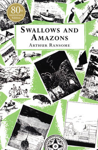
Swallows And Amazons

The ultimate children`s classic - long summer days filled with adventure. John, Susan, Titty and Roger sail their boat, Swallow, to a deserted island for a summer camping trip. Exploring and playing sailors is an adventure in itself but the island holds more excitement in store. Two fierce Amazon pirates, Nancy and Peggy, challenge them to war and a summer of battles and alliances ensues. `My childhood simply would not have been the same without this book. It created a whole world to explore, one that lasted long in the imagination after the final page had been read` - Marcus Sedgwick
RIP - This product is no longer available on our network. It was last seen on 25.09.2019

This page now acts as a permanent archive for this product. Add more information using the comments box below to ensure it can still be found by future generations.

Use our search facility to see if it is available from an alternative contributor.
  • Availability: Out Of Stock
  • Supplier: Stanfords
  • SKU: 9780099503910
Availability: In Stock
£7.99

Product Description

The ultimate children`s classic
- long summer days filled with adventure. John, Susan, Titty & Roger sail their boat, Swallow, to a deserted island for a summer camping trip. Exploring & playing sailors is an adventure in itself but the island holds more excitement in store. Two fierce Amazon pirates, Nancy & Peggy, challenge them to war & a summer of battles & alliances ensues. ` My childhood simply would not have been the same without this book. It created a whole world to explore, one that lasted long in the imagination after the final page had been read`
- Marcus Sedgwick

Reviews/Comments

Add New

Intelligent Comparison

Oooops!
We couldn't find anything!
Perhaps this product's unique.... Or perhaps we are still looking for comparisons!
Click to bump this page and we'll hurry up.

Price History

Vouchers

No voucher codes found.
Do you know a voucher code for this product or supplier? Add it to Insights for others to use.

Facebook

Jargon Buster

Summer - The season between Spring and Autumn. Usually the hottest season of the year
World - A physical grouping, commonly used to describe earth and everything associated with ti
Adventure - an undertaking of an exciting challenge or experience.
Classic - Something that is still like it was originally a high quality standard.
Children - A young life form within the early stages of physical development,

Supplier Information

Stanfords
Stanfords was established in 1853 and opened their iconic Covent Garden flagship store in 1901. They have become the top retailer of maps, travel books and accessories in the UK and arguably offer the largest selection of maps and travel books worldwide. Famous names such as Captain Robert Falcon Scott, Ranulph Fiennes and Michael Palin have purchased from Stanfords. They now have a shop in Bristol and both stores together with other venues operate a calendar of events including talks, book signings and exhibitions. As a specialist map retailer, the map selection is comprehensive and includes road maps, street maps and walking maps from worldwide destinations, as well as a selection of world atlases and wall maps. Books include travel guides and travel literature. Stanfords also stock globes, from miniatures made of blue marble to magnificent floor-standing globes. The website features a selection of interesting articles on travel topics.
Page Updated: 2023-11-12 20:15:36

Community Generated Product Tags

Oh No! The productWIKI community hasn't generated any tags for this product yet!
Menu