More From Contributor
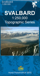
£9.99
Suva Mountains with the Gorges of the Jelašnicka River on a detailed contoured map at 1:55, 000, plus extensive information on the tourist facilities in the area with colour photos of mountain shelters, notes on fauna & flora, etc. The map has contours at 20m intervals with relief shading & colouring for woodlands. Different levels of protection zones are marked & areas where hunting is allowed are indicated. An overprint highlights waymarked hiking trails including the 130km long-distance trail across the Niš range. Also marked are different types of tourist accommodation including campsites & hunting lodges, paragliding sites, skiing areas, etc. The map has latitude & longitude lines at intervals of 5’. Map legend

Includes::
English. On the reverse are extensive bilingual notes on the area & its tourist facilities illustrated with numerous photos.

...
Archived Product
£8.99
One of the titles in a series of detailed touring maps of Lithuania with street plans of main towns. The maps, produced by Baltic States’ leading cartographic publisher, Jana Seta, show the country’s road network indicating three different kinds of unsurfaced roads & mark locations of petrol stations. Railway lines are shown with stations. Symbols highlight various types of accommodation including campsites, towns & other places of particular interest, border crossings, etc. National parks & protected areas are shown but, beyond rivers & other waterways, no topographic information is provided. Map legend

Includes::
English. Each map also

Includes::
plans of larger towns in the region, showing main streets & indicating locations of petrol stations, selected accommodation & places of interest. On the reverse there are photos & descriptions of all the regions’ main places of interest: historical monuments, local architecture, churches, natural features, etc. Although all the text is in Lithuanian only, the descriptions are cross-referenced to the map, providing a useful indicator of places worth visiting. In this titles: plans of Kaunas, Kazlu Ruda, Marijampole, Prienai, Šakiai, & Vilkaviškis.


...
Archived Product
£12.99
Suwalszczyzna in a series covering Poland’s best hiking areas on waterproof & tear-resistant, laminated maps, specially designed to withstand repeated re-folding & even the worst weather conditions. Each map is double-sided & has clear, well presented cartography with a contoured base (20m interval) &, where appropriate, relief shading, graphic relief in rocky areas, & spot heights. Extensive overprint highlights waymarked hiking trails & on many titles also cycling, skiing or canoeing routes. Symbols show accommodation facilities including hotels, campsites, youth hostels, mountain refuges, etc., restaurants & bars in more remote areas, local bus stops, petrol stations, medical facilities, etc. Many titles include street plans of holiday resorts. The maps have either a UTM or latitude/longitude grid. * Map legend

Includes::
English.** In this title:* Suwalszczyzna, the north-eastern corner of Pol&, covering an area from the border to Rajgrodzkie Lake & Elk. Overprint

Includes::
cycling routes. Canoeing routes are also marked, together with ferry routes along the Augustów Canal & other waterways.


...
Archived Product
£16.99
Topographic survey of Sweden at 1:50, 000, the Terrängkartan, from the Lantmäteriet, covering most of the country in 244 double-sided maps. Please note: the mountainous regions of central & northern Sweden are not covered by this series but presented in a separate “ Fjällkartan
- Mountain Map” series also listed on our website. Each 1:50, 000 topographic survey map covers an area of 37.5 x 40km. The maps have contours at 5 metre intervals, plus relief shading & graphics for rocky outcrops & boulders. Further graphics and/or colouring show different types of land use or vegetation (forests, arable l&, orchards, marshes, peat bogs, etc). An unusual feature of this survey is the colouring indicating buildings below or above two storeys high & “leisure/holiday homes”. The maps indicate privately maintained roads & include all other information expected of topographic survey at this scale. The maps have a 1-km UTM grid, plus latitude & longitude lines 5’ intervals. Map legend

Includes::
English. For coverage of the country’s most visited hiking areas in central & northern Sweden please see Lantmäteriet’s Mountain Map series, listed separately on our website.


...
Archived Product
£17.99
The Bradt guide to Svalbard (Spitsbergen), including Franz Josef Land & Jan Mayen, is a unique, standalone guidebook to this evocative Arctic archipelago, a place that is plunged into darkness for four months each year & where there are 4, 000 snow scooters for a population of just 2, 500. This new sixth edition has been thoroughly updated throughout & offers new material on everything from adventure tours to accommodation, environmental change to restaurants. Also covered are the restoration of Barentsburg & the opening of Svalbard`s historic mines to visitors. Newly updated & amended, this edition reflects important recent changes in the archipelago, making it the perfect guide to a quintessential bucket-list destination. Possibly the most remote destination in the developed world, Svalbard is as off the beaten track as you can get in Europe today. A destination where there are more polar bears than people, Svalbard is the planet`s most northerly settled land & the top (if not the end) of the world. It was on & around Svalbard that most of David Attenborough` Frozen Planet was filmed. A trip to Svalbard easily lends itself to notching up geographic superlatives (most northerly kebab, most northerly souvenir shop, etc) & adventurous travellers seek out experiences such as husky driving & hikes across the permafrost, charmed by the island law that requires everyone to carry a rifle anywhere outside of Longyearbyen, a constant reminder of Svalbard`s 3, 000-strong polar bear population. The main tourist period falls in Svalbard`s brief summer, from June to August, when it`s light around the clock & not very cold. However, increasingly popular for winter sports
- especially because the next few years will enjoy unusually high Northern Lights activity
- are the so-called `light winter` months (March-May), when there is both sunlight & snow. The winter season itself (November/ December-March) offers many possibilities for outdoor adventure
- & the polar night is an experience in itself. Despite winter temperatures that can drop to over 40 below zero, Svalbard`s glorious mountains, majestic fjords & sprawling valleys are the perfect setting for adventurous journeys out to the back of beyond, giving visitors a unique vantage point on a unique tourist destination. This br&-new edition of Svalbard provides all of the practical & background information you`ll need to explore this wild place, turning the hostile into the hospitable. Bradt`s Svalbard is written by Roger Norum, an expert in the region who writes regularly on northern Norway for the press & who teaches Norwegian language & translation at University College London. He is also a Research Fellow at the University of Leeds, where he carries out research on the links between tourism, travel writing & environmental change in the European Arctic.


...
Archived Product
£24.99
The north-eastern part of the Svalbard (Spitsbergen) group at 1:250, 000 in a new series of five topographic maps first published by the Norsk Polarinstitutt in late 2010, with extensive index of geographical features, glossary, rules for visitors, etc. The map covers the eastern part of Nordaustland & the adjoining islands, including Kvitøya, Kongsøya & Svenskøya. Maps in this series provide an excellent representation of the topography, with contours at 100m intervals enhanced by relief shading & numerous spot heights, plus colouring and/or graphics for glaciers, moraine, braided rivers & flat foreshore. Boundaries of nature conservation areas are clearly marked. The map shows roads & tracks or paths, as well as airfields & heliports, power lines & aerials cableways, lighthouses & masts, working & disused mines, etc. Within the settled areas schools, churches & medical facilities are also indicated. The maps have UTM plus latitude (15’) & longitude (30’) grids. Extensive index of geographical features gives locations by latitude/longitude coordinates. On the reverse of each title are two small maps of the whole group showing magnetic declination & nature conservation areas. Another map shows the area of Spitsbergen around the Isfjorden where visitors can travel without a permit. Each map also

Includes::
a glossary of geographical terms & notes on Svalbard’s cultural heritage. Map legend & all the text include English.

...
Archived Product
£24.99
The north-western part of the Svalbard (Spitsbergen) group at 1:250, 000 in a new series of five topographic maps first published by the Norsk Polarinstitutt in late 2010, with extensive index of geographical features, glossary, rules for visitors, etc. The map covers the north-western part of the Spitsbergen Isl&, including Longyearbyen & other settlements on the south side of Isfjorden. Maps in this series provide an excellent representation of the topography, with contours at 100m intervals enhanced by relief shading & numerous spot heights, plus colouring and/or graphics for glaciers, moraine, braided rivers & flat foreshore. Boundaries of nature conservation areas are clearly marked. The map shows roads & tracks or paths, as well as airfields & heliports, power lines & aerials cableways, lighthouses & masts, working & disused mines, etc. Within the settled areas schools, churches & medical facilities are also indicated. The maps have UTM plus latitude (15’) & longitude (30’) grids. Extensive index of geographical features gives locations by latitude/longitude coordinates. On the reverse of each title are two small maps of the whole group showing magnetic declination & nature conservation areas. Another map shows the area of Spitsbergen around the Isfjorden where visitors can travel without a permit. Each map also

Includes::
a glossary of geographical terms & notes on Svalbard’s cultural heritage. Map legend & all the text include English.

...
Archived Product
£24.99
The south-eastern part of the Svalbard (Spitsbergen) group at 1:250, 000 in a new series of five topographic maps first published by the Norsk Polarinstitutt in late 2010, with extensive index of geographical features, glossary, rules for visitors, etc. The map covers Barentsøya & Edgeøya, plus the islands further south including Hopen. Maps in this series provide an excellent representation of the topography, with contours at 100m intervals enhanced by relief shading & numerous spot heights, plus colouring and/or graphics for glaciers, moraine, braided rivers & flat foreshore. Boundaries of nature conservation areas are clearly marked. The map shows roads & tracks or paths, as well as airfields & heliports, power lines & aerials cableways, lighthouses & masts, working & disused mines, etc. Within the settled areas schools, churches & medical facilities are also indicated. The maps have UTM plus latitude (15’) & longitude (30’) grids. Extensive index of geographical features gives locations by latitude/longitude coordinates. On the reverse of each title are two small maps of the whole group showing magnetic declination & nature conservation areas. Another map shows the area of Spitsbergen around the Isfjorden where visitors can travel without a permit. Each map also

Includes::
a glossary of geographical terms & notes on Svalbard’s cultural heritage. Map legend & all the text include English.

...
Archived Product
£24.99
The south-western part of the Svalbard (Spitsbergen) group at 1:250, 000 in a new series of five topographic maps first published by the Norsk Polarinstitutt in late 2010, with extensive index of geographical features, glossary, rules for visitors, etc. The map covers the southern part of the Spitsbergen Isl&, including Longyearbyen & other settlements on the south side of Isfjorden. Bjørnøya is shown as an inset. Maps in this series provide an excellent representation of the topography, with contours at 100m intervals enhanced by relief shading & numerous spot heights, plus colouring and/or graphics for glaciers, moraine, braided rivers & flat foreshore. Boundaries of nature conservation areas are clearly marked. The map shows roads & tracks or paths, as well as airfields & heliports, power lines & aerials cableways, lighthouses & masts, working & disused mines, etc. Within the settled areas schools, churches & medical facilities are also indicated. The maps have UTM plus latitude (15’) & longitude (30’) grids. Extensive index of geographical features gives locations by latitude/longitude coordinates. On the reverse of each title are two small maps of the whole group showing magnetic declination & nature conservation areas. Another map shows the area of Spitsbergen around the Isfjorden where visitors can travel without a permit. Each map also

Includes::
a glossary of geographical terms & notes on Svalbard’s cultural heritage. Map legend & all the text include English.

...
Archived Product
£15.99
The Svalbard Archipelago: Spitsbergen, Nordaustlandet, Edgeoya & the smaller islands at 1:1, 000, 000 from the Norsk Polarinstitutt showing the topography, settlements, airfields, etc. The same map is available in two different versions: topographic edition & tourist version. The map itself is the same in both versions & presets the topography by contours at 200m intervals plus spot heights. The map shows settlements, roads, airfields, lighthouses, radio stations & beacons. Latitude lines are drawn at 1° intervals, with longitude at 3° but with margin ticks at 1°. Bjornoya is included on an inset.TOPOGRAPHIC VERSION (this map): the map has a bilingual Norwegian/ English legend & a glossary of topographic terms, &

Includes::
a small map indicating the extent of polar icecap in April & September, plus a grid showing the division of the archipelago into more detailed topographic coverage at 1:100, 000.TOURIST VERSION: there is no map legend or other information included on the topographic version. Instead the map is surrounded by photographs of various aspects of the archipelago.

...
Archived Product

Svalbard North

The northern part of the Svalbard (Spitsbergen) group at 1:250, 000 in a new series of five topographic maps first published by the Norsk Polarinstitutt in late 2010, with extensive index of geographical features, glossary, rules for visitors, etc. The map covers the western part of Nordaustlandet and the north-eastern part of Spitsbergen.Maps in this series provide an excellent representation of the topography, with contours at 100m intervals enhanced by relief shading and numerous spot heights, plus colouring and/or graphics for glaciers, moraine, braided rivers and flat foreshore. Boundaries of nature conservation areas are clearly marked.The map shows roads and tracks or paths, as well as airfields and heliports, power lines and aerials cableways, lighthouses and masts,
working and disused mines, etc. Within the settled areas schools, churches and medical facilities are also indicated. The maps have UTM plus latitude (15’) and longitude (30’) grids. Extensive index of geographical features gives locations by latitude/longitude coordinates.On the reverse of each title are two small maps of the whole group showing magnetic declination and nature conservation areas. Another map shows the area of Spitsbergen around the Isfjorden where visitors can travel without a permit. Each map also includes a glossary of geographical terms and notes on Svalbard’s cultural heritage. Map legend and all the text include English.
RIP - This product is no longer available on our network. It was last seen on 25.09.2019

This page now acts as a permanent archive for this product. Add more information using the comments box below to ensure it can still be found by future generations.

Use our search facility to see if it is available from an alternative contributor.
  • External links may include paid for promotion
  • Availability: Out Of Stock
  • Supplier: Stanfords
  • SKU: 9786000003548
Availability: In Stock
£24.99

Product Description

The northern part of the Svalbard (Spitsbergen) group at 1:250, 000 in a new series of five topographic maps first published by the Norsk Polarinstitutt in late 2010, with extensive index of geographical features, glossary, rules for visitors, etc. The map covers the western part of Nordaustlandet & the north-eastern part of Spitsbergen. Maps in this series provide an excellent representation of the topography, with contours at 100m intervals enhanced by relief shading & numerous spot heights, plus colouring and/or graphics for glaciers, moraine, braided rivers & flat foreshore. Boundaries of nature conservation areas are clearly marked. The map shows roads & tracks or paths, as well as airfields & heliports, power lines & aerials cableways, lighthouses & masts, working & disused mines, etc. Within the settled areas schools, churches & medical facilities are also indicated. The maps have UTM plus latitude (15’) & longitude (30’) grids. Extensive index of geographical features gives locations by latitude/longitude coordinates. On the reverse of each title are two small maps of the whole group showing magnetic declination & nature conservation areas. Another map shows the area of Spitsbergen around the Isfjorden where visitors can travel without a permit. Each map also

Includes::
a glossary of geographical terms & notes on Svalbard’s cultural heritage. Map legend & all the text include English.

Reviews/Comments

Add New

Price History

Vouchers

No voucher codes found.
Do you know a voucher code for this product or supplier? Add it to Insights for others to use.

Facebook

Jargon Buster

magnetic - A susbstance affected at a microscopic level by an applied magnetic field.
Graphics - A general term for visual aspects of an item/display
Small - something that takes up less space than normal.

Supplier Information

Stanfords
Stanfords was established in 1853 and opened their iconic Covent Garden flagship store in 1901. They have become the top retailer of maps, travel books and accessories in the UK and arguably offer the largest selection of maps and travel books worldwide. Famous names such as Captain Robert Falcon Scott, Ranulph Fiennes and Michael Palin have purchased from Stanfords. They now have a shop in Bristol and both stores together with other venues operate a calendar of events including talks, book signings and exhibitions. As a specialist map retailer, the map selection is comprehensive and includes road maps, street maps and walking maps from worldwide destinations, as well as a selection of world atlases and wall maps. Books include travel guides and travel literature. Stanfords also stock globes, from miniatures made of blue marble to magnificent floor-standing globes. The website features a selection of interesting articles on travel topics.
Page Updated: 2023-11-12 20:15:36

Community Generated Product Tags

Oh No! The productWIKI community hasn't generated any tags for this product yet!
Menu