
 United Kingdom
 France
 Germany
 Netherlands
 Sweden
 USA
USA
 Italy
Italy
 Spain
Spain
More From Contributor


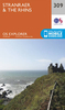


Stranraer And Glenluce OS ACTIVE Map
Map No. 82, Stranraer and Glenluce, in the waterproof and tear-resistant OS Active version of the Ordnance Survey Landranger series at 1:50, 000, including Kirkcolm, Leswalt, Cairnryan, New Luce, Kircowan, Dunragit, Stoneykirk, Portpatrick, Auchenmaig, Elrig, Port William, Sandhead, Ardwell, Port Logan and Drummore, with Loch Ryan, Milleur Point, Black Loch, White Loch, Castle Lock, Mochrum Loch, The Rhins, Mull of Galloway, Luce Bay and the Southern Upland Way.Edition C2; Publication date April 2012About Ordnance Survey
Product Description
Reviews/Comments
Add New
Vouchers
No voucher codes found.
Do you know a voucher code for this product or supplier? Add it to Insights for others to use.
Do you know a voucher code for this product or supplier? Add it to Insights for others to use.
 Denmark