
 United Kingdom
 France
 Germany
 Netherlands
 Sweden
 USA
USA
 Italy
Italy
 Spain
Spain
More From Contributor

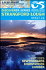

Strangford Lough Activity Map
Strangford Lough at 1:25, 000 on a large, double-sided Activity Map from the Ordnance Survey of Northern Ireland designed with outdoor enthusiasts in mind: waterproof and tear-resistant, topographic and GPS compatible, with hiking and cycling routes and tourist information for the area. Four enlargements at 1:10, 000 present in greater detail parts of the area covered by the main map: Mount Stewart, Scrabo County Park, Delamont Country Park, ant the Castleward area at the southern end of the lake around Portaferry and Strangford. Canoe trail access points and scuba diving sites are marked.Maps in this series have topographic base with contours at 10m intervals, altitude colouring and graphics for rocks, scree, boulders, mud and shingle, different types of woodlands, etc. Road
network indicates steep gradients and car parks, plus highlights scenic routes. The maps also show Sustrans National Cycle Network. Waymarked hiking paths are highlighted and a very wide range of symbols provides tourist information, indicating camping and caravan sites, youth hostels, nature reserves, museums, rock climbing / scuba diving / angling sites, etc. The map has Irish national grid lines at 1km intervals.To see the list of titles in this series please click on the series link.
network indicates steep gradients and car parks, plus highlights scenic routes. The maps also show Sustrans National Cycle Network. Waymarked hiking paths are highlighted and a very wide range of symbols provides tourist information, indicating camping and caravan sites, youth hostels, nature reserves, museums, rock climbing / scuba diving / angling sites, etc. The map has Irish national grid lines at 1km intervals.To see the list of titles in this series please click on the series link.
Product Description
Reviews/Comments
Add New
Vouchers
No voucher codes found.
Do you know a voucher code for this product or supplier? Add it to Insights for others to use.
Do you know a voucher code for this product or supplier? Add it to Insights for others to use.
 Denmark