More From Contributor

£6.99
A bilingual fiction title for children who are independent readers. The parallel text, speech bubbles & pictures by different, talented illustrators provide a child-friendly bridge to reading
- & speaking
- in another language. There is a quiz at the end of each story to help comprehension & revise vocabulary.

...
Archived Product
£9.99
More a memoir than a travelogue, Stranger on a Train is Jenny Diski’s account of daydreaming & smoking around America with interruptions
-
...
Archived Product
£8.99
As a child, all Aatish Taseer ever had of his father was his photograph in a browning silver frame. Raised by his Sikh mother in Delhi, his father, a Pakistani Muslim, remained a distant figure. It was a fractured upbringing which left Aatish with many questions about his own identity. Stranger to History is the story of the journey Aatish made to try to understand what it means to be Muslim in the twenty-first century. Starting from Istanbul, Islam`s once greatest city, he travels to Mecca, its most holy, & then home through Iran & Pakistan. Ending in Lahore, at his estranged father`s home, on the night Benazir Bhutto was killed, it is also the story of Aatish`s own divided family over the past fifty years. ...
Archived Product
£8.99
` He was haunted by a feeling of invisibility, as if he were a mere spectator of his own life, with no one to identify him in the barren circumstances of the here & now.` Paul Sturgis is a retired banker manager who lives alone in a dark little flat. He walks alone & dines alone, seeking out & taking pleasure in small exchanges with strangers: the cheerful Australian girl who cuts his hair, the lady at the drycleaners. His only relative, & only acquaintance, is a widowed cousin by marriage
- herself a virtual stranger
- to whom he pays ritualistic visits on a Sunday afternoon. Trying to make sense of his current solitary state, & fearing that his destiny may be to die among strangers, Sturgis trawls through memories of his failed relationships & finds himself longing for companionship, or at the very least a conversation. But then a chance encounter with a stranger
- a recently divorced & demanding younger woman
- shakes up his routine & when an old girlfriend appears on the scene, Sturgis is forced to make a decision about how (and with whom) he wants to spend the rest of his days.. .` Each book is a prayer bead on a string, & each prayer is a secular, circumspect prayer, a prayer & a protest & a charm against encroaching night` Hilary Mantel, Guardian ` No one writes with more skill & honesty about the human condition & this book is possibly her finest` Julie Myerson, Observer `A novel of great stylistic beauty & psychological truth. As great a reflection on fear & regret as Philip Larkin or Beckett` Guardian ` Like Graham Greene, she draws the reader into a world that has a character & signature all of its own.. . Strangers is a novel of sober brilliance, & the unerring, unflinching Brookner is still a much underestimated novelist` Helen Dunmore, The Times Anita Brookner was born in south London in 1928, the daughter of a Polish immigrant family. She trained as an art historian, & worked at the Courtauld Institute of Art until her retirement in 1988. She published her first novel, A Start in Life, in 1981 & her twenty-fourth, Strangers, in 2009. Hotel du Lac won the 1984 Booker Prize. As well as fiction, Anita Brookner has published a number of volumes of art criticism.


...
Archived Product
£8.99
This is an extraordinary & moving memoir by the award-winning author of ” Palestinian Walks”
- updated with a new foreword. Raja
...
Archived Product
£6.50
Strangford Lough, map No. 21 in the Discoverer series from the Ordnance Survey of Northern Ireland presenting the country on detailed topographic maps at 1:50, 000 with waymarked hiking trails, Sustrans National Cycle Network & other tourist information. Coverage

Includes::
Newtownards, Downpatrick & Comber. Current edition E; publication date April 2011. Maps in the Discoverer series have contours at 10m intervals, with plenty of spot heights & bold altitude colouring above 150m. Graphics indicate different types of woodlands. In coastal areas the maps show high & low water mark, cliffs, mud/shingle or s&, etc. Road network grades minor roads according to their widths,

Includes::
local tracks & shows gradients on steep routes. Railways are shown with stations & the maps include other details expected of topographic mapping at this scale. An overprint highlights waymarked walking trails as well as cycle routes of the Sustrans National Cycle Network. Boundaries of National Trust land are marked, indicating areas with limited opening. Places of interest are prominently highlighted & a range of symbols provide other tourist information including camping or caravan sites & youth hostels, bus stations, parking, picnic areas, viewpoints, gold courses, etc. Each map covers an area of 40 x 30km (25 x 19 miles approximately) & has a 1km Irish Grid, plus latitude & longitude margin ticks at 1` intervals. Map legend is English, French & German. On the reverse each sheet has an indexed monochrome map showing townland boundaries. To see the list of all the titles in this series please click on the series link.


...
Archived Product
£7.80
Strangford Lough at 1:25, 000 on a large, double-sided Activity Map from the Ordnance Survey of Northern Ireland designed with outdoor enthusiasts in mind: waterproof & tear-resistant, topographic & GPS compatible, with hiking & cycling routes & tourist information for the area. Four enlargements at 1:10, 000 present in greater detail parts of the area covered by the main map: Mount Stewart, Scrabo County Park, Delamont Country Park, ant the Castleward area at the southern end of the lake around Portaferry & Strangford. Canoe trail access points & scuba diving sites are marked. Maps in this series have topographic base with contours at 10m intervals, altitude colouring & graphics for rocks, scree, boulders, mud & shingle, different types of woodlands, etc. Road network indicates steep gradients & car parks, plus highlights scenic routes. The maps also show Sustrans National Cycle Network. Waymarked hiking paths are highlighted & a very wide range of symbols provides tourist information, indicating camping & caravan sites, youth hostels, nature reserves, museums, rock climbing / scuba diving / angling sites, etc. The map has Irish national grid lines at 1km intervals. To see the list of titles in this series please click on the series link. ...
Archived Product
£3.99
Strangford Lough Cycle Trail in a series of cycling maps from Sustrans, the charity behind developing UK’s National Cycle Network. The map is printed on light waterproof synthetic paper & presents the region at two scales. On one side is a wider area at 1:185, 000 showing the County Down Cycle Route; on the reverse the eastern part from Belfast around Strangford Lough is presented at 1:100, 000 with six insets showing the route across local towns. Each title in the Sustrans series of cycling maps covers either a single route, presented in sections on separate strip maps, or a wider area with the main cycling route (s) prominently highlighted but other recommendations for cyclists also marked. The area covered each map is shown on our website on its individual “coverage” image. The route has markers indicating steep gradients, controlled access, distances & possible danger points. Route profiles indicate riding surface & the density of traffic (main road, minor road & traffic-free) &, where appropriate, street plans show the course of the route across towns & cities. On maps covering a wider area around the main National Cycle Route suggestions of possible day ride excursions are also marked. A range of symbols highlight various facilities & places of interest, including tourist information centres, youth hostels, cafes & pubs, grocery shops, cycle shops & hire, historical & natural sites, etc. For access by rail, the rail network is shown with stations &, where appropriate, metro stations are also marked. Topography is shows by altitude colouring. Unless specifically indicated in the individual description, the maps do not show British National Grid lines for GPS. Each title also contains contact addresses for various useful organizations, etc. Many titles are printed on light, waterproof & tear-resistant synthetic paper. ...
Archived Product
£7.99
Why would anyone strangle a humble seamstress with no known enemies? When newly-married bookseller Victor Legris is asked to solve the murder of Louise Fontaine in the abattoir district of La Villette, he is initially baffled by the case. But as the investigation progresses, Victor, along with his assistant & brother-in-law Joseph, discovers that in belle-epoque Paris young girls with no money or background are as ruthlessly preyed on as ever they were - ...
Archived Product
£2.50
Stranraer street map from Nicolson Maps, Scotland’s premier cartographic publisher, including Cairnryan, Castle Kennedy, Creetown, Drummore, Dunragit, Garlieston, Glenluce, Isle of Whithorn, Kirkcolm, Kirkcowan, Leswalt, Lochans, Minnigaff, Newton Stewart, Portpatrick, Port William, Sandhead, Whithorn, Wigtown. This title is part of the Street Guide Maps series, offering excellent & clear mapping of cities, towns & villages around the Great Britain. Please note, there is no actual written informative text, but the richness of symbology will provide visitors with ample information. The Street Guide Maps series from Nicolson Maps, Scotland’s premier cartographic publisher, offers excellent & clear mapping of cities, towns & villages around the UK. Most Nicolson’s maps are double-sided &, when applicable, cover additional locations on separate panels, each with a street index. The plans indicate, usually by different colours, primary routes plus A & B roads. Other roads, streets, tracks & paths are clearly shown as well as railway & bus stations. Symbols highlight location of various facilities, such as schools, libraries, places of worship, emergency services, petrol stations & car parks. Other places of interests like camping & caravan sites, historic buildings, museums, castles, information points etc. are also shown. ...
Archived Product

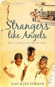
Strangers Like Angels: With A Devil Or Two To Boot

Strangers Like Angels chronicles the journeys of Alec and Jan Forman to far and distant lands as they embrace their pioneering spirit. Following adventures in Canada, Antarctica and the Sultanate of Oman they set off on the original gap year in the seventies. Travelling in their Land Rover, they use only a map and compass to navigate through the Sahara Desert and tropical rainforests in Africa, back to Europe and out to Asia via the Hindu Kush, and on to the Himalayas. They grapple with the realities of poverty and yet experience surprising hospitality and welcome from unlikely sources. In the confined space of their vehicle, Alec and Jan learn what it takes to support and sustain themselves and their relationship on an exciting and often harrowing journey. Exchange of news through
airmail letters to and from England keeps them in touch with family matters. Beautiful photographs and illustrations with maps complement the text, taking the reader along on the journey with Alec and Jan.A light, entertaining read of a true story of adventures, travel and divine encounter, blended with winsome tales to delight the heart, Strangers Like Angels will appeal to fans of memoirs and travel books.
RIP - This product is no longer available on our network. It was last seen on 25.09.2019

This page now acts as a permanent archive for this product. Add more information using the comments box below to ensure it can still be found by future generations.

Use our search facility to see if it is available from an alternative contributor.
  • Availability: Out Of Stock
  • Supplier: Stanfords
  • SKU: 9781783063628
Availability: In Stock
£12.99

Product Description

Strangers Like Angels chronicles the journeys of Alec & Jan Forman to far & distant lands as they embrace their pioneering spirit. Following adventures in Canada, Antarctica & the Sultanate of Oman they set off on the original gap year in the seventies. Travelling in their Land Rover, they use only a map & compass to navigate through the Sahara Desert & tropical rainforests in Africa, back to Europe & out to Asia via the Hindu Kush, & on to the Himalayas. They grapple with the realities of poverty & yet experience surprising hospitality & welcome from unlikely sources. In the confined space of their vehicle, Alec & Jan learn what it takes to support & sustain themselves & their relationship on an exciting & often harrowing journey. Exchange of news through airmail letters to & from England keeps them in touch with family matters. Beautiful photographs & illustrations with maps complement the text, taking the reader along on the journey with Alec & Jan.A light, entertaining read of a true story of adventures, travel & divine encounter, blended with winsome tales to delight the heart, Strangers Like Angels will appeal to fans of memoirs & travel books.

Reviews/Comments

Add New

Intelligent Comparison

Oooops!
We couldn't find anything!
Perhaps this product's unique.... Or perhaps we are still looking for comparisons!
Click to bump this page and we'll hurry up.

Price History

Vouchers

No voucher codes found.
Do you know a voucher code for this product or supplier? Add it to Insights for others to use.

Facebook

Jargon Buster

vehicle - A manufactured device used to transport people or cargo.
England - A country within the United Kingdom.
Year - The time it takes the planet earth to orbit the sun. This takes around 365.25 days.
Set - a group of items usually related to one another. Some objects cannot function without the complete set of items.
Heart - An organ that pumps blood around the body. Usually related to love.
Tropical - Coming fro the work "tropics" a hot and humid area of the world.
Experience - To gain further knowledge by practising.
illustrations - Pictures typically in books and newspapers.
Year - 365 days (366 days in a leap year), the time taken for planet earth to make one full revolution around the sun.
Family - A group of people that live together made up from parents and children.

Supplier Information

Stanfords
Stanfords was established in 1853 and opened their iconic Covent Garden flagship store in 1901. They have become the top retailer of maps, travel books and accessories in the UK and arguably offer the largest selection of maps and travel books worldwide. Famous names such as Captain Robert Falcon Scott, Ranulph Fiennes and Michael Palin have purchased from Stanfords. They now have a shop in Bristol and both stores together with other venues operate a calendar of events including talks, book signings and exhibitions. As a specialist map retailer, the map selection is comprehensive and includes road maps, street maps and walking maps from worldwide destinations, as well as a selection of world atlases and wall maps. Books include travel guides and travel literature. Stanfords also stock globes, from miniatures made of blue marble to magnificent floor-standing globes. The website features a selection of interesting articles on travel topics.
Page Updated: 2023-11-12 20:15:36

Community Generated Product Tags

Oh No! The productWIKI community hasn't generated any tags for this product yet!
Menu