More From Contributor

£7.99
Svalbard archipelago, including Kvitøya, Kong Karls L&, & Bjørnøya (Bear Island) at 1:1, 000, 000 approx. on a tourist map with extensive additional information, photos of fauna & flora, biographies of explorers, etc. On one side is a map of the whole Svalbard group with Bjørnøya shown as an inset, showing settlements & naming numerous topographic features such as peaks, glaciers, bays & fjords, etc. The map had latitude lines at 1º & longitude at 3º. Two insets provide a locator map showing the position of the group within the North Polar Region & its protected areas including bird colonies. Also provided is a Norwegian/ English glossary plus a chart of the sun’s yearly cycle at Longyearbyen. The whole of the reverse side is covered by biographies of 27 explorers connected with Svalbard from Willem Barents to Umberto Nobile, plus colour photos & descriptions of several species of fauna & flora. ...
Archived Product
£19.99
One of the titles in a series of topographic maps with contours at 100m intervals. Physical features shown include moraine, rocks, coastline with flat foreshore, etc. The maps also show settlements, roads, mines, cabins, radio stations, aerial cableways, airfields, etc. National park & nature reserve boundaries are marked. The maps have a UTM grid & lines of longitude & latitude shown at 1° & 30` intervals respectively. The map was originally published in 1982; the map legend also

Includes::
English.

...
Archived Product
£17.99
One of the titles in a series of topographic maps with contours at 100m intervals. Physical features shown include moraine, rocks, coastline with flat foreshore, etc. The maps also show settlements, roads, mines, cabins, radio stations, aerial cableways, airfields, etc. National park & nature reserve boundaries are marked. The maps have a UTM grid & lines of longitude & latitude shown at 1° & 30` intervals respectively. This map was originally published in 1979, the map legend also

Includes::
English.

...
Archived Product
£12.99
Map No. 1154, Spitzmeilen, in the topographic survey of Switzerland at 1:25, 000 from Bundesamt für Landestopographie (swisstopo), covering the whole country on 247 small format sheets, with special larger maps published for popular regions including some titles now available in hiking versions. Highly regarded for their superb use of graphic relief & hill shading, the maps give an almost 3-D picture of Switzerland`s mountainous terrain. Contours are at 10 m intervals, with 20m intervals in the mountainous areas. All the maps have a 1-km grid for Swiss national coordinates (datum CH 1903). * Small format sheets (Nos. 1011
- 1374)* Map legend in the language of the area covered by the map. Additional margin ticks show latitude & longitude in steps of 2`. The area covered by each map is 17 x 12 km (11 x 7 miles approx). * Special larger sheets (Nos. from 2501 onwards) – STANDARD editions:* No map legend is included but a separate leaflet can be provided instead. The area covered by each map is 25 x 17 km (15 x 11 miles approx).* Special larger sheets (Nos. from 2501 onwards) – HIKING editions:* An overprint highlights hiking, mountain & alpine paths, including regional & national long-distance trails. The maps also show bus routes with bus stops, plus inns in remote locations. The area covered by each map is 25 x 17 km (15 x 11 miles approx).
...
Archived Product
£6.99
Join Splat the Cat on a school trip to the zoo to see his favourite animals in bestselling picture book author Rob Scotton`s hilarious new adventure. Splat the Cat is so excited when Mrs. Wimpydimple announces that the class will be going to the zoo. While everyone calls out his or her favourite animal-Elephant! Giraffe! Monkey!-Splat only wants to see the penguins. After all, penguins are perfect; they are black & white, just like Splat! All day long, Splat just can`t wait. But when the smallest animal makes the biggest splash & shuts down the penguin exhibit, Splat goes home disappointed & alone.. .or does he? Fans of Splat the Cat will delight in this funny story about animals & enjoy Splat`s always-present enthusiasm. ...
Archived Product
£6.99
How tall was the tallest snowman ever built? 37.21 metres. What's impossible to overtake at Christmas? The Three Wide Men! That's just a sample of the festive jokes & facts which fill this massive activity book. Featuring a cast of quirky characters from Dickens, the North Pole & the Nativity, this book is guaranteed to entertain anyone in the festive spirit with its blend of eye-boggling facts & inventive & involving puzzles. This Splat-a-fact Activity Book features a huge variety of puzzles & activities. It has something for everyone & is big enough to keep children entertained & interested for hours on end. ...
Archived Product
£6.99
What's that evil cackling around the corner? Oh, it's someone enjoying the jokes in our great new Splat-a-Fact Spooky Activity Book! Meet Dr. Zog's terrifying team of reanimated creatures, mumbling mummies, hairy werewolves, wicked witches & vampires young & old. Can you unwrap the mummy, escape the haunted house, pick up the bones & count the creeps? It's the perfect way to have some creative fun & learn more about the spooks of Halloween. This Splat-a-fact Activity Book features a huge variety of puzzles & activities. It has something for everyone & is big enough to keep children entertained & interested for hours on end. ...
Archived Product
£19.99
Splugen
- San Bernardino area at 1:60, 000 in Kümmerly + Frey’s hiking series of Switzerl&, with most titles now printed on light,
...
Archived Product
£12.99
Map No. 1255, Splügenpass, in the topographic survey of Switzerland at 1:25, 000 from Bundesamt für Landestopographie (swisstopo), covering the whole country on 247 small format sheets, with special larger maps published for popular regions including some titles now available in hiking versions. Highly regarded for their superb use of graphic relief & hill shading, the maps give an almost 3-D picture of Switzerland`s mountainous terrain. Contours are at 10 m intervals, with 20m intervals in the mountainous areas. All the maps have a 1-km grid for Swiss national coordinates (datum CH 1903). * Small format sheets (Nos. 1011
- 1374)* Map legend in the language of the area covered by the map. Additional margin ticks show latitude & longitude in steps of 2`. The area covered by each map is 17 x 12 km (11 x 7 miles approx). * Special larger sheets (Nos. from 2501 onwards) – STANDARD editions:* No map legend is included but a separate leaflet can be provided instead. The area covered by each map is 25 x 17 km (15 x 11 miles approx).* Special larger sheets (Nos. from 2501 onwards) – HIKING editions:* An overprint highlights hiking, mountain & alpine paths, including regional & national long-distance trails. The maps also show bus routes with bus stops, plus inns in remote locations. The area covered by each map is 25 x 17 km (15 x 11 miles approx).
...
Archived Product
£9.99
” When Yellow Snake was born he had bright red dots. But then he grew. His new spots were blue!” So begins this book about the simple adventures of one intrepid little snake. As he wanders through a variety of bright, textured landscapes, ”growing” longer & longer on each page, the snake`s spots seem to magically change colour every time the page is turned. The snake itself is printed on a yellow ribbon that winds itself throughout the book. Children will learn all about colours while they
- & the adults reading to them
- will scratch their heads trying to figure out how it`s done. Has a great surprise ending!

...
Archived Product

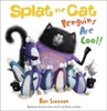
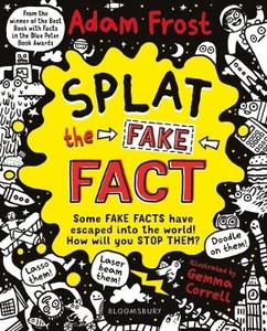
Splat The Fake Fact!: Doodle On Them, Laser Beam Them, Lasso Them

Some incorrect facts have escaped from author Adam Frost`s imagination into this book...Can you figure out which fact is untrue in a sea of brilliantly weird, wonderful and unusual facts? Once you find them make sure you SPLAT them, lasso them, doodle on them - and reveal them as an imposter facts before they go out into the world!Can you guess which of these facts is NOT true? Woodlice have blue blood.Dead cabbage cafe is the name of a band. King Edward III banned football in England. You swallow about one litre of snot a day! (That`s roughly five skips FULL of snot, swallowed during your lifetime.)When glass snakes are attacked, their tail shatters into little pieces - these pieces jump around and distract the predator... while the rest of the snake escapes! Hunt for fascinating
facts and use your detective skills to uncover the untrue `fact`. With hilarious illustrations from the brilliant Gemma Correll, you`ll need all your brains to uncover the false fact: can you `squash` the made-up bug fact, decipher hieroglyphics, and join the stars in a night-time sky to find all the answers? Put your skills to the test as you Splat the Fact!
RIP - This product is no longer available on our network. It was last seen on 25.09.2019

This page now acts as a permanent archive for this product. Add more information using the comments box below to ensure it can still be found by future generations.

Use our search facility to see if it is available from an alternative contributor.
  • Availability: Out Of Stock
  • Supplier: Stanfords
  • SKU: 9781408889503
Availability: In Stock
£6.99

Product Description

Some incorrect facts have escaped from author Adam Frost`s imagination into this book... Can you figure out which fact is untrue in a sea of brilliantly weird, wonderful & unusual facts? Once you find them make sure you SPLAT them, lasso them, doodle on them
- & reveal them as an imposter facts before they go out into the world! Can you guess which of these facts is NOT true? Woodlice have blue blood. Dead cabbage cafe is the name of a b&. King Edward III banned football in Engl&. You swallow about one litre of snot a day! (That`s roughly five skips FULL of snot, swallowed during your lifetime.) When glass snakes are attacked, their tail shatters into little pieces
- these pieces jump around & distract the predator... while the rest of the snake escapes! Hunt for fascinating facts & use your detective skills to uncover the untrue `fact`. With hilarious illustrations from the brilliant Gemma Correll, you`ll need all your brains to uncover the false fact: can you `squash` the made-up bug fact, decipher hieroglyphics, & join the stars in a night-time sky to find all the answers? Put your skills to the test as you Splat the Fact!

Reviews/Comments

Add New

Intelligent Comparison

Oooops!
We couldn't find anything!
Perhaps this product's unique.... Or perhaps we are still looking for comparisons!
Click to bump this page and we'll hurry up.

Price History

Vouchers

No voucher codes found.
Do you know a voucher code for this product or supplier? Add it to Insights for others to use.

Facebook

Jargon Buster

Litre - A unit of volume equivilent to 1000 Mililitres
Football - A sport involving kicking a ball and trying to score a goal
Blue - A primary colour
Glass - A solid, typically transparent. Brittle and used in windows. The first patent granted in the UK was for Glass.
England - A country within the United Kingdom.
World - A physical grouping, commonly used to describe earth and everything associated with ti
King - The figure head of a monarch
Day - The time it takes a planet or other space objects to complete one rotation.
Unusual - Something unique and different.
illustrations - Pictures typically in books and newspapers.
Blood - A red liquid that circulates around the body for all the bodies needs.
Guess - An American luxury brand of clothing and accessories
Wonderful - Another word for describing something that is extremely good, marvellous.

Supplier Information

Stanfords
Stanfords was established in 1853 and opened their iconic Covent Garden flagship store in 1901. They have become the top retailer of maps, travel books and accessories in the UK and arguably offer the largest selection of maps and travel books worldwide. Famous names such as Captain Robert Falcon Scott, Ranulph Fiennes and Michael Palin have purchased from Stanfords. They now have a shop in Bristol and both stores together with other venues operate a calendar of events including talks, book signings and exhibitions. As a specialist map retailer, the map selection is comprehensive and includes road maps, street maps and walking maps from worldwide destinations, as well as a selection of world atlases and wall maps. Books include travel guides and travel literature. Stanfords also stock globes, from miniatures made of blue marble to magnificent floor-standing globes. The website features a selection of interesting articles on travel topics.
Page Updated: 2023-11-12 20:15:36

Community Generated Product Tags

Oh No! The productWIKI community hasn't generated any tags for this product yet!
Menu