
 United Kingdom
 France
 Germany
 Netherlands
 Sweden
 USA
USA
 Italy
Italy
 Spain
Spain
More From Contributor

Spain Borch
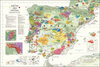
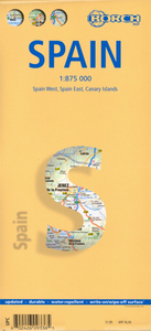
Laminated, waterproof and tear resistant, indexed road map of Spain, ideal for route-planning. The map is double-sided, dividing the country north/south with a generous overlap. Spain`s motorway network stands out prominently against the background of other roads and geographical information, with junction numbers and various facilities clearly marked. Connecting local roads are easy to see and numerous places of interest are highlighted. National Parks, churches, motels, restaurants and other points of interest are clearly marked. The map grid is marked at half degree intervals. There is very subtle relief shading with spot heights clearly indicated- although this map is much more suited for road-use.The map also includes an inset of the Canary islands (1:875, 000 scale), as well
as smaller insets showing the administrative divisions of Spain, ferry lines of Spain, and time zones within Europe, as well as general statistics such as climate and conversion rates (at time of printing).*Map legend includes English.*
as smaller insets showing the administrative divisions of Spain, ferry lines of Spain, and time zones within Europe, as well as general statistics such as climate and conversion rates (at time of printing).*Map legend includes English.*

Product Description
Reviews/Comments
Add New
Intelligent Comparison
Archived Product
Miami Borch Stanfords
£8.99
Archived Product
Paris Borch Stanfords
£8.99
Archived Product
Thailand Borch Stanfords
£9.99
Archived Product
Spain Northern Stanfords
£5.99
Archived Product
Spain Northern Stanfords
£6.99
Vouchers
No voucher codes found.
Do you know a voucher code for this product or supplier? Add it to Insights for others to use.
Do you know a voucher code for this product or supplier? Add it to Insights for others to use.
 Denmark