
 United Kingdom
 France
 Germany
 Netherlands
 Sweden
 USA
USA
 Italy
Italy
 Spain
Spain
More From Contributor


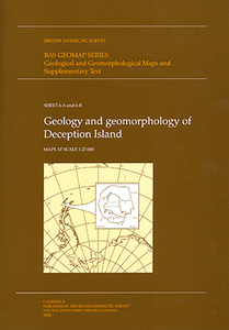
South Shetland Islands: Deception Island Geology And Geomorphology Map
And Supplementary Text
Deception Island in the South Shetland Islands archipelago is one of the most visited parts of the Antarctic and the most active volcano in west Antarctica. “Geology and Geomorphology of Deception Island” presents three separate maps at 1:25, 000: topographic, geological and geomorphological, published as a joint venture by geoscientists of the British Antarctic Survey and the Programma Español de Investigación en la Antártida, with topographic mapping provided by Servicio Geográfico del Ejército, Spain’s military survey organization. Accompanying the maps is a 77-page, A4 illustrated book presenting a comprehensive overview of the history, topography, geology and geomorphology of this important island in the South Shetland Islands group: Full BAS ref. number: BAS GEOMAP
Series, sheets 6a and 6B, 2012.PLEASE NOTE: to see the list of other BAS maps of wider general interest please click on the series link. A separate series on our website presents BAS titles which are of interest mainly to scientific experts or academic staff: larger scale topographic or geological/earth sciences maps of sections of the Antarctic and maps accompanied by detailed booklets/monographs.
Series, sheets 6a and 6B, 2012.PLEASE NOTE: to see the list of other BAS maps of wider general interest please click on the series link. A separate series on our website presents BAS titles which are of interest mainly to scientific experts or academic staff: larger scale topographic or geological/earth sciences maps of sections of the Antarctic and maps accompanied by detailed booklets/monographs.

Product Description
Reviews/Comments
Add New
Vouchers
No voucher codes found.
Do you know a voucher code for this product or supplier? Add it to Insights for others to use.
Do you know a voucher code for this product or supplier? Add it to Insights for others to use.
 Denmark