More From Contributor

£10.50
Putumayo World Music presents Gypsy Groove, a collection of Balkan beats, gypsy jams & other treats from the leaders of this vibrant music scene. CD Track listing:1! Dela Dap, ' Zsa Manca' (Czech Republic/ Hungary) 2 Shantel, ' Bucovina' (Germany) 3 Gipsy.cz, ' Jednou' (Czech Republic) 4 Amsterdam Klezmer B&, ' Sadagora Hot Dub' (Netherlands) 5 Balkan Beat Box, ' Sunday Arak' (USA/ Israel) 6 Karen Gafurdjanov, ' Yor Uzga' (Uzbekistan) 7 Magnifico & Turbolentza, ' Zh Ne Sui Pa Pur Tua' (Slovenia) 8 Anselmo Crew, 'S ...
Archived Product
£14.99
Lake Geneva & Western Switzerland in the Sunflower Landscapes guide series; exploring the best walking & touring possibilities in the region or area. Detailed information about touring by hired car or public transport, as well as on foot, is provided, helping walkers to navigate & plan day-trips. Shorter strolls are also included as an alternative for each main route for those seeking more leisurely days out. The guide is structured in two main parts – Touring & Walking – that explore each route with detailed references to public transport & car directions to make each walk more accessible. Suggested car-touring routes of the area are also included. Each describes a route by car with suggestions for stop-off places & things to see on the way, including any picnicking sites. Fifteen suggestions for the best picnic stops are included at the start of the book & these are cross-referenced with the fold-out map & walk descriptions. The ‘ Walking’ section

Includes::
fifteen recommended walks, many of which are circular tours. A detailed introduction provides information on waymarking & maps, what to take, weather & where to stay. Each walk begins with information about distance, difficulty grading, waymarking, how to get there, suggested clothing & equipment, language hints & shorter & alternative routes to the main walk. An appendice provides useful guidance on local transport. Colour photographs & Ordnance Survey extracts accompany each route.

...
Archived Product
£2.50
German in the Fast Talk Series from Lonely Planet, comprising a selection of handy, pocket-sized language guides designed to be practical & easy to use. Each guide provides essential language for short trips & covers a range of different situations with appropriate vocabulary. There are individual sections entitled Chat, Explore, (sights) Shop, Enjoy, (what’s on & small talk) Eat & Drink, Services, (including bank & post office vocabulary) Go, (transport) Sleep, Work (business) & Help (emergencies & police), all with easy pronunciation guides. A ‘ Look Up’ section provides useful information on numbers, colours & time & dates. There are also comprehensive English-French & French-English dictionaries, allowing users to look up vocabulary easily. ...
Archived Product
£9.99
Great Britain
- Not For Parents by Lonely Planet is not a guidebook. & it is definitely `not-for-parents`. It is the real, inside
...
Archived Product
£31.99
Road Atlas of the Peloponnese from Anavasi, in an A4 paperback format, with contoured, GPS compatible mapping at 1:50, 000, very detailed road classification, hiking paths, & place names in both Greek & Latin alphabets. The main section of the atlas has 178 pages of detailed maps with contours at 100m intervals, altitude colouring & relief shading to provide a vivid representation of the terrain. Nearly all names: town & villages, geographical features, etc, are given in both Greek & Latin alphabets, with just minor local churches shown in Greek only. Names of most archeological sites & many other places of interest are given in Greek & in English. Road classification has 10 different grades, from toll motorways to minor dirt roads in poor condition & 4WD tracks. Intermediate driving distances are shown on main & secondary roads. The maps also indicate locations of petrol stations (with names of oil companies) & tire repairs facilities. Local footpaths are also marked, with the E4 trans-European long-distance trail & routes 031, 032 & 033 highlighted. A wide range of symbols mark locations of various places of interest including accommodation (hotels, campsites, summer camps, mountain refuges), archaeological sites, churches & monasteries, beaches, caves, viewpoints, etc. The maps have a 2km UTM grid & 1’ latitude/longitude ticks. Map legend

Includes::
English. Two indexes, one for each alphabet, include separate sections listing archaeological sites & religious monuments. The atlas also has a 12 page section showing the Peloponnese at 1:250, 000 for more general route planning. Also included are two tables giving driving distance & driving times between over 60 locations. Current edition of this atlas was published in 2009.

...
Archived Product
£5.99
The Rough Guide German Phrasebook is the definitive phrasebook to help you make the most of your time in Germany. Whether you want to book a hotel room, ask what time the train leaves or buy a drink from the bar, this new phrasebook has a dictionary of over 5, 000 words & will help you communicate with the locals in no time. The free audio downloads, recorded by native German speakers, can be downloaded to your computer or MP3, allowing you to listen to the correct pronunciation of essential dialogues, ideal for practicing before you go or while you`re there. There is even a regional pronunciation guide & Rough Guide travel tips, so wherever you are you can get around & speak the lingo. ” The Rough Guide German Phrasebook” has an extensive two-way dictionary packed with vocabulary & a helpful menu & drinks list reader, perfect for choosing the right dish in any restaurant. With this phrasebook in your pocket you will never run out of things to say. ...
Archived Product
£5.99
Whether you want to book a hotel room, ask what time the train leaves or buy a drink from the bar, this Rough Guide phrasebook has a dictionary of over 5, 000 words & will help you communicate with the locals in no time. The free audio downloads, recorded by native Greek speakers, can be downloaded to your computer or MP3 player. They allow you to listen to the correct pronunciation of essential dialogues & are ideal for practicing before you go or while you`re there. There`s even a regional pronunciation guide & Rough Guide travel tips section, so wherever you are you can get around & speak the lingo. The Rough Guide Greek Phrasebook has an extensive two-way dictionary packed with vocabulary &

Includes::
a helpful menu & drinks list reader, perfect for choosing the right dish in any restaurant.

...
Archived Product
£24.99
Deception Island in the South Shetland Islands archipelago is one of the most visited parts of the Antarctic & the most active volcano in west Antarctica. “ Geology & Geomorphology of Deception Island” presents three separate maps at 1:25, 000: topographic, geological & geomorphological, published as a joint venture by geoscientists of the British Antarctic Survey & the Programma Español de Investigación en la Antártida, with topographic mapping provided by Servicio Geográfico del Ejército, Spain’s military survey organization. Accompanying the maps is a 77-page, A4 illustrated book presenting a comprehensive overview of the history, topography, geology & geomorphology of this important island in the South Shetland Islands group: Full BAS ref. number: BAS GEOMAP Series, sheets 6a & 6B, 2012.PLEASE NOTE: to see the list of other BAS maps of wider general interest please click on the series link. A separate series on our website presents BAS titles which are of interest mainly to scientific experts or academic staff: larger scale topographic or geological/earth sciences maps of sections of the Antarctic & maps accompanied by detailed booklets/monographs. ...
Archived Product
£35.00
This functional map shows every star directly observable by the naked eye indicated by magnitude & brightness. Also mapped are the nebulae, star clusters & galaxies visible from Earth. Original 17th century illustrations by Polish astronomer Johannes Hevelius depict the creatures & characters that inspired ancient astronomers to identify the constellations
- we’ve included both Latin & English names. Their intricacy contrasts against eye-popping fluo, shimmering metallics & midnight blue, bringing the constellations to life. The result is a unique, educational map that makes a fantastic piece of wall art for dreamers & realists alike. Printed on to the highest quality FSC approved silk-coated paper using the lithographic printing process. A plate is made for each colour & then laid down individually, creating a stunning print with maximum definition & impact. A sealer is applied to protect the inks & gloss UV varnish is used to add contrast & highlight design features.
...
Archived Product

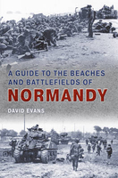
Normandy: Guide To The Beaches And Battlefields

A Guide to the Beaches and Battlefields of Normandy provides an accessible background to the momentous events of 6 June 1944 as well as a complete guide to each and every town, village, beach, battery and cemetery that figured in the battle. This comprehensive book contains a wealth of detail that charts the heroism, poignancy and tragedy of events that were to alter the course of history. With stories, poems and illustrations, David Evans pays a fitting tribute to those who gave their lives as the price of victory. Accompanied by photographs, maps and drawings, this guide is aimed primarily at the thousands of veterans, relatives and tourists who visit Normandy each year, but it will also be an endless source of enjoyment to those who wish to recall the details and monuments of
the battle in the comfort of their own homes. David Evans is a lecturer in modern history and is a frequent visitor to the sites of Normandy battlefields.
RIP - This product is no longer available on our network. It was last seen on 25.09.2019

This page now acts as a permanent archive for this product. Add more information using the comments box below to ensure it can still be found by future generations.

Use our search facility to see if it is available from an alternative contributor.
  • Availability: Out Of Stock
  • Supplier: Stanfords
  • SKU: 9781848681842
Availability: In Stock
£14.99

Product Description

A Guide to the Beaches & Battlefields of Normandy provides an accessible background to the momentous events of 6 June 1944 as well as a complete guide to each & every town, village, beach, battery & cemetery that figured in the battle. This comprehensive book contains a wealth of detail that charts the heroism, poignancy & tragedy of events that were to alter the course of history. With stories, poems & illustrations, David Evans pays a fitting tribute to those who gave their lives as the price of victory. Accompanied by photographs, maps & drawings, this guide is aimed primarily at the thousands of veterans, relatives & tourists who visit Normandy each year, but it will also be an endless source of enjoyment to those who wish to recall the details & monuments of the battle in the comfort of their own homes. David Evans is a lecturer in modern history & is a frequent visitor to the sites of Normandy battlefields.

Reviews/Comments

Add New

Intelligent Comparison

Oooops!
We couldn't find anything!
Perhaps this product's unique.... Or perhaps we are still looking for comparisons!
Click to bump this page and we'll hurry up.

Price History

Vouchers

No voucher codes found.
Do you know a voucher code for this product or supplier? Add it to Insights for others to use.

Facebook

Jargon Buster

Battery - A device used for the storage of electricity
Beach - An area on the coast consisting of a sandy or pebbled area
History - Anything that happens in the past. An acedemic subject.
Year - The time it takes the planet earth to orbit the sun. This takes around 365.25 days.
Comfort - something that feels nice to the user. Often relaxing.
illustrations - Pictures typically in books and newspapers.
Year - 365 days (366 days in a leap year), the time taken for planet earth to make one full revolution around the sun.

Supplier Information

Stanfords
Stanfords was established in 1853 and opened their iconic Covent Garden flagship store in 1901. They have become the top retailer of maps, travel books and accessories in the UK and arguably offer the largest selection of maps and travel books worldwide. Famous names such as Captain Robert Falcon Scott, Ranulph Fiennes and Michael Palin have purchased from Stanfords. They now have a shop in Bristol and both stores together with other venues operate a calendar of events including talks, book signings and exhibitions. As a specialist map retailer, the map selection is comprehensive and includes road maps, street maps and walking maps from worldwide destinations, as well as a selection of world atlases and wall maps. Books include travel guides and travel literature. Stanfords also stock globes, from miniatures made of blue marble to magnificent floor-standing globes. The website features a selection of interesting articles on travel topics.
Page Updated: 2023-11-12 20:15:36

Community Generated Product Tags

Oh No! The productWIKI community hasn't generated any tags for this product yet!
Menu