
 United Kingdom
 France
 Germany
 Netherlands
 Sweden
 USA
USA
 Italy
Italy
 Spain
Spain
More From Contributor

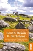

South Devon Postcode Sector Map PAPER
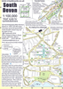
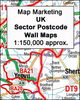
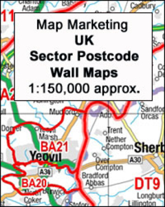
South Devon Postcode Sector Map at 1:150, 000, paper version, in a series of postcode sector maps showing the first part of the postcode and the first number of the second part, the Inward Code. Coverage extends north to Bridgewater, south to Salcombe, east to Dorchester and west to Tavistock.Map Marketing’s series of postcode sector maps covers Great Britain and Northern Ireland on 36 titles, each available only as a flat map, either on paper or encapsulated for greater durability. Presentation includes postcode changes in the most recent Royal Mail Postcode updates. The series covers Great Britain at 1:150, 000 (1” to 2.4 miles), with Northern Ireland shown at 1:210, 000 and London at two scales: 1:60, 000 for the area within the M25 and in more detail at 1:15, 000 for
central London. Postcode area, district and sector boundaries and numbers/letters are shown in red, with County and Unitary Authority boundaries in green. The map base shows motorways, primary, ‘A’ and down to unclassified roads, with conurbation shapes and city plan insets showing street level detail for major cities. To see the list of all the titles in this series please click on the series link.
central London. Postcode area, district and sector boundaries and numbers/letters are shown in red, with County and Unitary Authority boundaries in green. The map base shows motorways, primary, ‘A’ and down to unclassified roads, with conurbation shapes and city plan insets showing street level detail for major cities. To see the list of all the titles in this series please click on the series link.

Product Description
Reviews/Comments
Add New
Vouchers
No voucher codes found.
Do you know a voucher code for this product or supplier? Add it to Insights for others to use.
Do you know a voucher code for this product or supplier? Add it to Insights for others to use.
 Denmark