More From Contributor
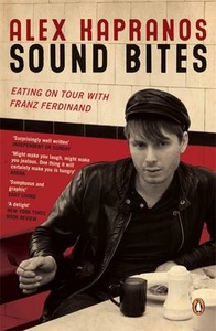
£25.00
The word mezze stems from the Arabic term `tamazzaza`
- a single word that broadly embraces the idea of enjoying small portions
...
Archived Product
£14.99
An English professor at North Carolina State University, Barbara Bennett spent a recent sabbatical as a hands-on volunteer, working with lions, leopards, & other wild creatures at Harnas Wildlife Foundation in Namibia. Based on her incredible experiences there, she authored this beautiful book
- part nature story, part far-flung adventure, part biography of the amazing proprietor of Harnas, & part call to action on behalf of embattled wildlife. At the sanctuary, founder Marieta van der Merwe & her family care for more than 400 rescued, injured, & orphaned animals including cheetahs, leopards, lions, monkeys, meerkats, & wild dogs, as well as domestic dogs & cats. The animals come from farmers protecting their stock, from road accidents, & from misguided owners who try to domesticate wild pets. Harnas runs a variety of programs to heal, release, protect, & care for them. A typical scene at Harnas might involve workers seated under a tree in the heat of the day, supervising a playdate for scampering baby baboons. Or bottle-feeding a six-month-old giraffe whose legs alone are the height of an adult human. Or taking an evening stroll with half-grown lion cubs who might turn & playfully pounce at any moment. Every scrape was a badge of honour. We all hoped one of these injuries would scar. It would be the cocktail party story that tops all others, recalls the author. But her most magical experience at Harnas
- one that will bring awe & envy to every cat-lover in the audience
- was sleeping out in the enclosure alongside beautiful Cleo & Pride, lulled by their loud purrs & kept warm by 300 pounds of magnificent cheetah. The story of Harnas isn`t just about animals. Readers will become fans of brave, tenacious Marieta, who has accomplished much despite tremendous hardships. Learn of movie star Angelina Jolie`s devotion to Harnas. & get to know the Bushmen who work at the sanctuary. People, wildlife, nation, & environment
- all play a part in this candid & page-turning adventure, at once daring, dangerous, funny, & forever heartwarming.


...
Archived Product
£12.99
The de Boer family are tobacco growers, working on terraces in the Veneto region of northern Italy. Life is hard, & the father, Augusto, occasionally supplements their income by smuggling tobacco across the border into Austria. Sometimes he takes his daughter Jole with him, & father & daughter journey together on the perilous route over the mountains. But Augusto mysteriously never returns from one of these trips, & Jole, driven to provide for her family, inherits her father`s smuggling route. Accompanied only by her horse, Sansom, she must retrace the dangerous journey through the spectacular landscape, hoping for a good trade in exchange for her tobacco, but also to discover the truth behind her father`s disappearance. Written in a spare crystalline prose & filmic in scope, Soul of the Border is an epic story of revenge & salvation, a ferocious tale of violence & corruption, & a journey into the wild. ...
Archived Product
£12.99
Topographic survey of France at 1:25, 000 in IGN`s excellent TOP25 / Série Bleue series. All the maps are GPS compatible, with a 1km UTM grid plus latitude & longitude lines at 5’ intervals. Contours are at 5m intervals except for mountainous areas where the maps have contours at 10m intervals, vividly enhanced by hill shading & graphics for rocky terrain. Colouring with graphics indicates different types of vegetation or land use (deciduous or coniferous forests, moors, orchards, vineyards, etc). PLEASE NOTE: coverage of France at this scale is currently being revised – the format & the presentation of each title are indicated by the letters at the end of its Sheet Reference number (e.g. 0416ET, 3531ETR, 1923SB, etc.)MAPS WITH FULL TOURIST OVERPRINT & AN ENGLISH MAP LEGEND: all TOP25 maps & the SB editions of Série Bleue have an overprint highlighting waymarked walking trails including long-distance GR routes &, where appropriate, ski routes. Symbols indicate campsites, gîtes d’etape, refuges, equestrian centres & other recreational facilities or sites, tourist information centres, cultural heritage, etc. Towns & locations of particular interest are highlighted.- ET or OT = single-sided TOP25 map covering approx. 29x 21 km / 18x 13 miles.- ETR or OTR = waterproof & tear resistant TOP25 map covering the same area as the corresponding ET or OT number, but double-sided, printed on a smaller size sheet with a good overlap between the sides.- SB = Série Bleue map with full tourist overprint; these maps, first introduced in summer 2014, each cover approx. 29x 24km / 18x 15 miles.SÉRIE BLEUE maps with numbers ending in E (Est) or O (Ouest): most editions now indicate the GR routes, but do not show any other tourist information. Map legend is in French only. Each map covers approx. 14x 20km / 9x 12 miles. ...
Archived Product
£9.00
This pack of Flip Cards illustrates the signals made by ships at sea, & covers lights, fog signals & the usual distress & search & rescue signals. They differ from the Lights & Shapes cards in that they show signals rather than navigation signs. The meaning is shown on the back of the card as usual. There are 47 cards in the pack. ...
Archived Product
£5.99
Cuddly Cow is ready for bed, but she can`t get to sleep anywhere! As she visits her farmyard friends, will she find the perfect place to get a good night`s sleep? Little fingers will just love pushing the big sound button to hear Cuddly`s noisy mooing on every page. ...
Archived Product
£5.99
Portly Pig loves nothing more than being mucky! He sets off around the farm in search of a big muddy puddle, but what will he do when it starts to rain? Little fingers will just love pushing the big sound button to hear Portly`s noisy oinking on every page. ...
Archived Product
£11.99
The calls of 94 bird species, recorded in 1990 in the Tambopata-Candamo Reserved Zone, now the Tambopata National Reserve. All species are listed in the inlay card. Proceeds from the sale of this cd go towards the Tambopata Reserve Society (TRee S) which is pressing for biodiversity conservation & sound environmental management in the rainforests of the Department of Madre de Dios. ...
Archived Product
£14.99
Waterproof & tear-resistant OS Active version of map No. 18 from the Ordnance Survey’s Landranger series at 1:50, 000, with contoured & GPS compatible topographic mapping plus tourist information.MOBILE DOWNLOADS: As well as the physical edition of the map, each Landranger title now

Includes::
a code for downloading after purchase its digital version onto your smartphone or tablet for viewing on the OS smartphone app.OS LANDRANGER SERIES: to see the list of all the titles in the OS Landranger series, both paper & waterproof versions, please click on the series link. Maps in the Landranger series provide plenty of recreational & tourist information, indicating the traditional public right of way paths (except in Scotland where different laws apply), including bridleways & byways restricted or open to motorized traffic. National Trails & selected other long-distance paths are marked, as well as on-road & traffic-free cycle routes with their National/ Regional Cycle Network numbers. National Trust/ National Trust for Scotland & Forestry Commission land is clearly marked, indicating open or restricted access. A range of symbols highlights camping & caravanning sites, youth hostels, tourist information offices & visitors’ centres, parking & picnicking places, World Heritage sites, sport & recreational facilities, etc. The maps provide detailed presentation of topography with contours at 10m intervals, numerous spot heights & additional colouring and/or graphics for different types of woodlands, orchards or parkl&, rock features including scree & cliffs, water features inland & along the sea shore with marshl&, dunes, s&, mud, shingle & the high water mark. All the standard information expected of survey mapping at this scale is included: finely graded road network, railway lines with stations, cuttings, embankments, etc; individual isolated buildings; archaeological & historical sites, etc. For GPS users the British National Grid is shown at 1km intervals, with latitude & longitude given by margin ticks at 1` & cross hairs on the map at 5`. Each map covers an area of 40 x 40km, (approx. 25 x 25 miles).

...
Archived Product
£8.99
Paper version of map No. 18 from the Ordnance Survey’s Landranger series at 1:50, 000, with contoured & GPS compatible topographic mapping plus tourist information.MOBILE DOWNLOADS: As well as the physical edition of the map, each Landranger title now

Includes::
a code for downloading after purchase its digital version onto your smartphone or tablet for viewing on the OS smartphone app.OS LANDRANGER SERIES: to see the list of all the titles in the OS Landranger series, both paper & waterproof versions, please click on the series link. Maps in the Landranger series provide plenty of recreational & tourist information, indicating the traditional public right of way paths (except in Scotland where different laws apply), including bridleways & byways restricted or open to motorized traffic. National Trails & selected other long-distance paths are marked, as well as on-road & traffic-free cycle routes with their National/ Regional Cycle Network numbers. National Trust/ National Trust for Scotland & Forestry Commission land is clearly marked, indicating open or restricted access. A range of symbols highlights camping & caravanning sites, youth hostels, tourist information offices & visitors’ centres, parking & picnicking places, World Heritage sites, sport & recreational facilities, etc. The maps provide detailed presentation of topography with contours at 10m intervals, numerous spot heights & additional colouring and/or graphics for different types of woodlands, orchards or parkl&, rock features including scree & cliffs, water features inland & along the sea shore with marshl&, dunes, s&, mud, shingle & the high water mark. All the standard information expected of survey mapping at this scale is included: finely graded road network, railway lines with stations, cuttings, embankments, etc; individual isolated buildings; archaeological & historical sites, etc. For GPS users the British National Grid is shown at 1km intervals, with latitude & longitude given by margin ticks at 1` & cross hairs on the map at 5`. Each map covers an area of 40 x 40km, (approx. 25 x 25 miles).

...
Archived Product

Sound Bites

In September 2005, Alex Kapranos began writing about what he ate while touring the world with the rock band Franz Ferdinand. The writing is as much about where he eats and the people he eats with as the unusual flavours he tastes on the road. Whether it`s munching donuts with cops in Brooklyn, swallowing bull`s balls with the band in Buenos Aires or queuing for a saveloy in South Shields, these are surprising and vivid snapshots of life on the road. Funny, poignant, sickening or sexual depending on the situation, the material, both new and previously published in the ”Guardian”, is fascinating and entertaining.
RIP - This product is no longer available on our network. It was last seen on 25.09.2019

This page now acts as a permanent archive for this product. Add more information using the comments box below to ensure it can still be found by future generations.

Use our search facility to see if it is available from an alternative contributor.
  • Availability: Out Of Stock
  • Supplier: Stanfords
  • SKU: 9780141029030
Availability: In Stock
£7.99

Product Description

In September 2005, Alex Kapranos began writing about what he ate while touring the world with the rock band Franz Ferdin&. The writing is as much about where he eats & the people he eats with as the unusual flavours he tastes on the road. Whether it`s munching donuts with cops in Brooklyn, swallowing bull`s balls with the band in Buenos Aires or queuing for a saveloy in South Shields, these are surprising & vivid snapshots of life on the road. Funny, poignant, sickening or sexual depending on the situation, the material, both new & previously published in the ” Guardian”, is fascinating & entertaining.

Reviews/Comments

Add New

Intelligent Comparison

Oooops!
We couldn't find anything!
Perhaps this product's unique.... Or perhaps we are still looking for comparisons!
Click to bump this page and we'll hurry up.

Price History

Vouchers

No voucher codes found.
Do you know a voucher code for this product or supplier? Add it to Insights for others to use.

Facebook

Jargon Buster

World - A physical grouping, commonly used to describe earth and everything associated with ti
Road - a manmade lane or a path that is used to speed up travel.
Unusual - Something unique and different.

Supplier Information

Stanfords
Stanfords was established in 1853 and opened their iconic Covent Garden flagship store in 1901. They have become the top retailer of maps, travel books and accessories in the UK and arguably offer the largest selection of maps and travel books worldwide. Famous names such as Captain Robert Falcon Scott, Ranulph Fiennes and Michael Palin have purchased from Stanfords. They now have a shop in Bristol and both stores together with other venues operate a calendar of events including talks, book signings and exhibitions. As a specialist map retailer, the map selection is comprehensive and includes road maps, street maps and walking maps from worldwide destinations, as well as a selection of world atlases and wall maps. Books include travel guides and travel literature. Stanfords also stock globes, from miniatures made of blue marble to magnificent floor-standing globes. The website features a selection of interesting articles on travel topics.
Page Updated: 2023-11-12 20:15:36

Community Generated Product Tags

Oh No! The productWIKI community hasn't generated any tags for this product yet!
Menu