
 United Kingdom
 France
 Germany
 Netherlands
 Sweden
 USA
USA
 Italy
Italy
 Spain
Spain
More From Contributor


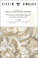
Sikkim Himalaya
Sikkim Himalaya on a detailed 1:150, 000 map from the Swiss Foundation for Alpine Research, with its monochrome presentation providing, on close inspection, far more detail than on other, more colorful maps.The cartography is in black and white with brown relief shading, contours at 100m intervals, spot heights for peaks and passes, names of peaks and glaciers, and graphics to show various types of terrain and vegetation: rock, moraine, scree, forests, scrub, lakes and waterfalls. Settlements, roads and tracks are shown, as well as international and provincial boundaries. Coverage extends south to Darjeeling, and within Nepal to the western edge of the Kanchenjunga Glacier. Latitude and longitude lines are drawn at intervals of 5`. Map legend includes Englis

Product Description
Reviews/Comments
Add New
Vouchers
No voucher codes found.
Do you know a voucher code for this product or supplier? Add it to Insights for others to use.
Do you know a voucher code for this product or supplier? Add it to Insights for others to use.
 Denmark