
 United Kingdom
 France
 Germany
 Netherlands
 Sweden
 USA
USA
 Italy
Italy
 Spain
Spain
More From Contributor


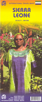
Sierra Leone ITMB
General, indexed road map of the country with a basic Freetown street plan and brief notes on the country’s history and places of interest. Altitude colouring and spot heights indicate the relief, and swamp areas are also are indicated. Road detail includes selected minor roads and tracks. The map also shows both the railway from Freetown into the interior and the mineral railway between Pepel & Lunsar. Administrative boundaries are not marked but towns which are district or provincial centres are indicated as such. Symbols denote airports, ports, ferries, petrol stations, post offices, hospitals, missions, antiquities, places of interest, various types of accommodation, etc. National parks and reserves are marked. Latitude and longitude lines are at 30` intervals.The central
Freetpown streetplan is not indexed and indicates only a few landmarks, eg. the Connaught Hopstal and the US Embassy.
Freetpown streetplan is not indexed and indicates only a few landmarks, eg. the Connaught Hopstal and the US Embassy.

Product Description
Reviews/Comments
Add New
Vouchers
No voucher codes found.
Do you know a voucher code for this product or supplier? Add it to Insights for others to use.
Do you know a voucher code for this product or supplier? Add it to Insights for others to use.
 Denmark