
 United Kingdom
 France
 Germany
 Netherlands
 Sweden
 USA
USA
 Italy
Italy
 Spain
Spain
More From Contributor


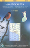

Saar-Hunsrück Nature Park East
The eastern part of the Saar-Hunsrück Nature Park on a GPS compatible, topographic recreational map at 1:50, 000 from the survey organizations of Rhineland-Palatinate and Saarland with cartography identical to the standard topographic survey of Germany but with additional extensive overprint highlighting local and long-distance hiking trails, cycle routes, sightseeing touring routes, various facilities including different types of accommodation, places of interest, etc. Map legend is in German only.Each title in the Rhineland-Palatinate recreational series is designed to cover a popular tourist area and several maps are double-sided. An overprint highlights hiking trails, on many maps indicating routes for different types of interest, e.g. geological, nature, bird watching,
etc. Also marked are cycling routes and, on some titles, ski trails. A wide range of symbols show various types of accommodation (campsites, youth hostels, etc), eating places, sport and recreational facilities, and historical sites, etc. All maps, unless indicated to the contrary in the individual description, have a UTM grid and a map legend in German only.This title is also available as part of a 2-map set which includes coverage of the western part of the park. To see the list of currently available titles please click on the series link.
etc. Also marked are cycling routes and, on some titles, ski trails. A wide range of symbols show various types of accommodation (campsites, youth hostels, etc), eating places, sport and recreational facilities, and historical sites, etc. All maps, unless indicated to the contrary in the individual description, have a UTM grid and a map legend in German only.This title is also available as part of a 2-map set which includes coverage of the western part of the park. To see the list of currently available titles please click on the series link.

Product Description
Reviews/Comments
Add New
Vouchers
No voucher codes found.
Do you know a voucher code for this product or supplier? Add it to Insights for others to use.
Do you know a voucher code for this product or supplier? Add it to Insights for others to use.
 Denmark