More From Contributor

£6.95
Rotterdam in the Wallpaper* City Guide series, published by Phaidon & encompassing a collection of pocket-size guides dedicated to the best design elements in major cities. Compiled by experts at the Wallpaper* magazine, the guides are widely recognized for appealing to design-conscious travellers & are aimed at those interested in art, design & architecture. Each guide identifies the best bars, restaurants, hotels, places to shop, leisure activities & excursions with a unique emphasis on the finest examples of unusual architecture & design. Each Wallpaper* City Guide has the same layout, with separate tabs allowing readers & travellers to access individual sections easily. The tabs consist of Landmarks, Hotels, 24 Hours, Urban Life, Architour, Shopping, Sports & Escapes. High quality colour photographs appear alongside brief descriptions of each hotel, bar or attraction, highlighting distinctive & unusual styles of architecture & design. Extra pages are provided at the back of each guide, allowing readers to record their own notes & sketches. ...
Archived Product
£17.99
Kadaster, Holland`s national survey organization, produces one of the most attractive topographic surveys in Europe. The maps are very colourful, with their characteristic patchwork of polders & an unusually large amount of land use information: meadows, arable l&, different types of forest, marshes, sand dunes, etc. Contours are shown at 5-metre intervals with numerous spot heights &, with such a large part of the country below the sea level, ”spot depths”. Each map covers an area of Approx. 25 x 20 km / 15 x 12 miles, with some sheets slightly larger. The maps have a 1-km Dutch national grid, plus latitude & longitude at intervals of 1`. Map legend

Includes::
English.IMPORTANT
- PLEASE NOTE BEFORE ORDERING: both the west (W) & the east (O) sheet of each number has the same name, although the town after which the two maps are named appears only on one of the sheets. For example: maps 41W & 41O are both called Arnhem, although the city of Arnhem appears only on sheet 40W, etc. To see the list of titles available in this series please click on the series link.


...
Archived Product
£8.50
Street plan of the Rouen agglomeration at 1:14, 000 with an enlargement showing the town centre in greater detail, the street index & information on the city’s hotels, public transport, sights, etc, included in a separate booklet. This title is part of an extensive series of street plans of French towns from Blay-Foldex, the country’s largest, oldest & most experienced publisher of urban mapping. Blay plans include outer suburbs &, where appropriate, adjoining localities forming part of the urban agglomeration & provide brief descriptions of the town’s main sights, contact details for hotels & other places of interest, etc. The plans show one way streets, car parks & pedestrian zones. Important public buildings are clearly marked & identified. Blay street maps are usually double-sided & include an enlargement for the town centre & a street index with separate lists of “edifices publics”: main public buildings, places of worship, schools, sport facilities, stations, etc. Each of the outer suburbs or the adjoining localities, identified with its postcode, has a separate index. Many titles also provide a road map of the environs. All the text is in French only.PLEASE NOTE: to see the list of Blay-Foldex street plans of French towns & cities please click on the series link – the series description also

Includes::
a comparison between Blay & IGN street plans.

...
Archived Product
£12.99
Topographic survey of France at 1:25, 000 in IGN`s excellent TOP25 / Série Bleue series. All the maps are GPS compatible, with a 1km UTM grid plus latitude & longitude lines at 5’ intervals. Contours are at 5m intervals except for mountainous areas where the maps have contours at 10m intervals, vividly enhanced by hill shading & graphics for rocky terrain. Colouring with graphics indicates different types of vegetation or land use (deciduous or coniferous forests, moors, orchards, vineyards, etc). PLEASE NOTE: coverage of France at this scale is currently being revised – the format & the presentation of each title are indicated by the letters at the end of its Sheet Reference number (e.g. 0416ET, 3531ETR, 1923SB, etc.)MAPS WITH FULL TOURIST OVERPRINT & AN ENGLISH MAP LEGEND: all TOP25 maps & the SB editions of Série Bleue have an overprint highlighting waymarked walking trails including long-distance GR routes &, where appropriate, ski routes. Symbols indicate campsites, gîtes d’etape, refuges, equestrian centres & other recreational facilities or sites, tourist information centres, cultural heritage, etc. Towns & locations of particular interest are highlighted.- ET or OT = single-sided TOP25 map covering approx. 29x 21 km / 18x 13 miles.- ETR or OTR = waterproof & tear resistant TOP25 map covering the same area as the corresponding ET or OT number, but double-sided, printed on a smaller size sheet with a good overlap between the sides.- SB = Série Bleue map with full tourist overprint; these maps, first introduced in summer 2014, each cover approx. 29x 24km / 18x 15 miles.SÉRIE BLEUE maps with numbers ending in E (Est) or O (Ouest): most editions now indicate the GR routes, but do not show any other tourist information. Map legend is in French only. Each map covers approx. 14x 20km / 9x 12 miles. ...
Archived Product
£8.99
Map No. 107, Rouen
- Le Havre, at 1:100, 000, part of the TOP100 series from the Institut Géographique National (IGN). These
...
Archived Product
£6.99
Whether you want to explore the history of Joan of Arc, experience the joie de vivre of Rouen, or stroll through the wooded valley of the Seine, Footprint Focus proves an invaluable guide. This compact yet concise book will steer you towards the most interesting sights that Upper Normandy has to offer, as well as ensuring you enjoy undiscovered corners too. Comprehensive listings of the best food, drink & accommodation will help you make the most of your trip. Essentials section with useful advice on getting to & around Rouen & Upper Normandy. Comprehensive, up-to-date listings of where to eat, sleep & play.

Includes::
information on tour operators & activities, from stylish shopping to climbing up to chateaux. Detailed maps for the Upper Normandy & other key destinations. Slim enough to fit in your pocket. With detailed information on all the main sights, plus many lesser-known attractions, Footprint Focus Rouen & Upper Normandy provides concise & comprehensive coverage of one of France's most interesting regions. The content of the Footprint Focus Rouen & Upper Normandy guide has been extracted from Footprint's Normandy Full-Color Guide.

...
Archived Product
£7.50
Street plan of Rouen at 1:12, 500 from the Institut Géographique National, the country’s national survey organization, with an enlargement showing the town centre in greater detail, plus a diagram of the bus network.IGN street plans include outer suburbs &, where appropriate, adjoining localities forming part of the urban agglomeration. The plans prominently highlight principal traffic arteries & show one way streets, car parks & pedestrian zones. Latest editions also indicate 24h petrol stations & streets with separate cycle paths. Many streets are annotated with selected house for easier identification of addresses. Important public buildings are named & symbols mark locations of tourist information centres & other facilities. Street index, arranged by an administrative area, is next to the map. Map legend

Includes::
English.PLEASE NOTE: to see the list of IGN street plans of French towns & cities please click on the series link – the series description also

Includes::
a comparison between IGN & Blay-Foldex street plans.


...
Archived Product
£10.95
Bob Roberts & his friend Bully worked nights & saved every penny they could make to buy Thelma, a 27-foot Looe smack, & fit her out for her epic voyage. After testing her out in the North Sea, they headed for Panama, by way of Madeira & the Azores. Australia was in their minds, as times were hard in Engl&. Their plans fell apart in the Cocos islands, where they were shipwrecked, & soon found themselves on a hair-raising voyage with treasure hunters aboard the bluenose schooner, ” Franklin Barnet”. ...
Archived Product
£9.99
Rough Crossings is the astonishing story of the struggle to freedom by thousands of African-American slaves who fled the plantations to fight behind British lines in the American War of Independence. With gripping, powerfully vivid story-telling, Simon Schama follows the escaped blacks into the fires of the war, & into freezing, inhospitable Nova Scotia where many who had served the Crown were betrayed in their promises to receive land at the war`s end. Their fate became entwined with British abolitionists: inspirational figures such as Granville Sharp, the flute-playing father-figure of slave freedom, & John Clarkson, the ` Moses` of this great exodus, who accompanied the blacks on their final rough crossing to Africa, where they hoped that freedom would finally greet them. ...
Archived Product
£7.99
The Countries, Regions & Cities series from Rough Guides are comprehensively detailed guidebooks specifically designed for independent travellers & serve a range of destinations worldwide. Widely recognised for their free editorial style, Rough Guide authors are allowed to express their personal opinions on a range of subjects. Although sometimes controversial, this editorial stance allows readers to experience more detailed & personal takes on each destination, a feature often more limited in other guidebooks. Cultural & historical nuances are explored in significant depth throughout the text & descriptions on the ambience of individual settings alongside personal recommendations, particularly in cities, are notably prevalent. Each Rough Guide in the Countries, Regions & Cities series has a similar layout. A ‘ Basics’ section gives practical guidance on getting there & around, accommodation, food & drink, festivals, sports & outdoor activities, travelling with children & travel essentials to take on the trip. Each guide is organised geographically by region, with individual sections detailing an extensive range of sights, places of interest, attractions, restaurants, nightlife, accommodation & any local activities. Cultural & historical context is interwoven throughout the text, allowing readers to get a more distinct flavour of the destination. Each chapter of the guide begins with a Highlights section giving an overview of the main sites & attractions in the area or region, with page numbers where relevant. Basic street outlines are also included for major cities. Information Boxes throughout the text explore local history, culture, customs & leisure activities, often providing an alternative & personal view of the area. A ‘ Contexts’ section is included at the back of each guide, offering insight into the local history & recommended books & films that characterise the country, region or city. ...
Archived Product

Rouen And Its Environs IGN Map

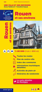
Rouen and its Environs in a series of detailed road maps at 1:80, 000 from the IGN, designed to highlight places of interest and recreational possibilities, with a city centre street plan and an enlargement of a selected hiking area.Cartography is an enlargement from 1:100, 000 to 1:80, 000 of the publisher’s highly popular TOP100 series, with very detailed presentation of the road network, including classification of local roads according to lanes, rest areas, access restrictions, etc. Railway lines are shown with stations. Topography is shown by relief shading, with spot heights and colouring for woodlands, vineyards, orchards, etc. Cycle tracks and long-distance GR routes are marked. A wide range of symbols indicate various places of interest and recreational facilities,
historical and cultural sites, golf courses, rock climbing, nature reserves, etc. Refuges and gîtes d’etape are marked, but no campsites. The maps have no geographical coordinates for GPS. Each title has an index of communes. Map legend includes English.A special feature of this series is the inclusion of a large city centre street plan and an enlargement of a particularly interesting recreational area. Presentation of these features varies, so please check the individual descriptions for more information.* IN THIS TITLE: a large street plan of Rouen’s city centre highlighting main traffic arteries and indicating one way streets. An additional panel presents an extract from IGN’s topographic coverage of the area around Montigny, just west of the city, in their TOP25 series
but shown here at 1:30, 000. The extract highlights local hiking routes.
RIP - This product is no longer available on our network. It was last seen on 25.09.2019

This page now acts as a permanent archive for this product. Add more information using the comments box below to ensure it can still be found by future generations.

Use our search facility to see if it is available from an alternative contributor.
  • Availability: Out Of Stock
  • Supplier: Stanfords
  • SKU: 9782758526667
Availability: In Stock
£7.50

Product Description

Rouen & its Environs in a series of detailed road maps at 1:80, 000 from the IGN, designed to highlight places of interest & recreational possibilities, with a city centre street plan & an enlargement of a selected hiking area. Cartography is an enlargement from 1:100, 000 to 1:80, 000 of the publisher’s highly popular TOP100 series, with very detailed presentation of the road network, including classification of local roads according to lanes, rest areas, access restrictions, etc. Railway lines are shown with stations. Topography is shown by relief shading, with spot heights & colouring for woodlands, vineyards, orchards, etc. Cycle tracks & long-distance GR routes are marked. A wide range of symbols indicate various places of interest & recreational facilities, historical & cultural sites, golf courses, rock climbing, nature reserves, etc. Refuges & gîtes d’etape are marked, but no campsites. The maps have no geographical coordinates for GPS. Each title has an index of communes. Map legend

Includes::
English.A special feature of this series is the inclusion of a large city centre street plan & an enlargement of a particularly interesting recreational area. Presentation of these features varies, so please check the individual descriptions for more information.* IN THIS TITLE: a large street plan of Rouen’s city centre highlighting main traffic arteries & indicating one way streets. An additional panel presents an extract from IGN’s topographic coverage of the area around Montigny, just west of the city, in their TOP25 series but shown here at 1:30, 000. The extract highlights local hiking routes.

Reviews/Comments

Add New

Price History

Vouchers

No voucher codes found.
Do you know a voucher code for this product or supplier? Add it to Insights for others to use.

Facebook

Jargon Buster

GPS - Global Positioning System - Global position using satellites
Hiking - An outdoor activity envolving walking in nature
Network - A link and communication between things. Often computers or people.
Large - something that takes up more space than normal.
Road - a manmade lane or a path that is used to speed up travel.
Wide - Something with a large width.
Golf - A sport played on a large outside grass course, the aim to hit a small ball with a club into small holes.
Popular - Something that is admired and liked by many people.
Feature - An attribute that makes something stand out.
Individual - A single separate item or person.

Supplier Information

Stanfords
Stanfords was established in 1853 and opened their iconic Covent Garden flagship store in 1901. They have become the top retailer of maps, travel books and accessories in the UK and arguably offer the largest selection of maps and travel books worldwide. Famous names such as Captain Robert Falcon Scott, Ranulph Fiennes and Michael Palin have purchased from Stanfords. They now have a shop in Bristol and both stores together with other venues operate a calendar of events including talks, book signings and exhibitions. As a specialist map retailer, the map selection is comprehensive and includes road maps, street maps and walking maps from worldwide destinations, as well as a selection of world atlases and wall maps. Books include travel guides and travel literature. Stanfords also stock globes, from miniatures made of blue marble to magnificent floor-standing globes. The website features a selection of interesting articles on travel topics.
Page Updated: 2023-11-12 20:15:36

Community Generated Product Tags

Oh No! The productWIKI community hasn't generated any tags for this product yet!
Menu