
 United Kingdom
 France
 Germany
 Netherlands
 Sweden
 USA
USA
 Italy
Italy
 Spain
Spain
More From Contributor


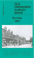
Romiley 1897
Romiley in 1897 in a fascinating series of reproductions of old Ordnance Survey plans in the Alan Godfrey Editions, ideal for anyone interested in the history of their neighbourhood or family. Selected towns in Great Britain and Ireland are covered by maps showing the extent of urban development in the last decades of the 19th and early 20th century.In this title: the map covers most of the village of Romiley, just east of Stockport. Coverage stretches from Bredbury House and Harrytown Lane eastward to Birchvale Farm. Features include River Goyt, railway with Romiley station, Peak Forest Canal, Oakwood Mill, Guywood, St Chad's church, Chadkirk House, Burymewick, Hole House Fold, Hatherlow, Bredbury Green, Harrytown Hall, Bunkers Hill etc. On the reverse is a directory of
Romiley plus a railway timetable for the Hayfield-Manchester line in 1916. About the Alan Godfrey Editions of the 25
Romiley plus a railway timetable for the Hayfield-Manchester line in 1916. About the Alan Godfrey Editions of the 25
Product Description
Reviews/Comments
Add New
Intelligent Comparison
Archived Product
Romiley 1897 Stanfords
£3.50
Archived Product
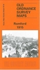
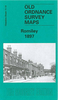
Woodley 1897 Stanfords
£2.95
Archived Product

Woodley 1897 Stanfords
£3.50
Vouchers
No voucher codes found.
Do you know a voucher code for this product or supplier? Add it to Insights for others to use.
Do you know a voucher code for this product or supplier? Add it to Insights for others to use.
 Denmark