
 United Kingdom
 France
 Germany
 Netherlands
 Sweden
 USA
USA
 Italy
Italy
 Spain
Spain
More From Contributor


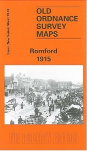
Romford 1915
Romford in 1915 in a fascinating series of reproductions of old Ordnance Survey plans in the Alan Godfrey Editions, ideal for anyone interested in the history of their neighbourhood or family. The map covers much of the centre and southern end of Romford, stretching from Crown Farm on the outskirts of the town eastward to King Edward Road, and from the Cattle Market and St Edward`s church southward to Rush Green Road. The GER railway runs west-east across the map, and features include Romford Brewery with its rail connections, the workhouse, Hornchurch Road, London Road, cemetery, Oldchurch Road, Mawheys Road, High Street, North Street, South Street, etc. At the start of the 20th century Romford was regarded as ”a lovely old market town surrounded by many country
villages” and, as in many other market towns, the brewery is shown as much the most important industry. It was established in 1799 by Edward Ind, who was later joined by Octavius and George Coope.About the Alan Godfrey Editions of the 25” OS Series:Selected towns in Great Britain and Ireland are covered by maps showing the extent of urban development in the last decades of the 19th and early 20th century. The plans have been taken from the Ordnance Survey mapping and reprinted at about 15 inches to one mile (1:4, 340). On the reverse most maps have historical notes and many also include extracts from contemporary directories. Most maps cover about one mile (1.6kms) north/south, one and a half miles (2.4kms) across; adjoining sheets can be combined to provide wider coverage.FOR MORE
INFORMATION AND A COMPLETE LIST OF ALL AVAILABLE TITLES PLEASE CLICK ON THE SERIES LINK.

Product Description
Reviews/Comments
Add New
Intelligent Comparison
Archived Product

Woodford 1915 Stanfords
£3.50
Vouchers
No voucher codes found.
Do you know a voucher code for this product or supplier? Add it to Insights for others to use.
Do you know a voucher code for this product or supplier? Add it to Insights for others to use.
 Denmark