
 United Kingdom
 France
 Germany
 Netherlands
 Sweden
 USA
USA
 Italy
Italy
 Spain
Spain
More From Contributor


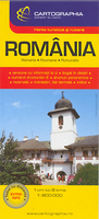
Romania
Overview road map of the country with an index and a distance table on the reverse. Relief shading and colouring, with spot heights and names of peaks and mountain ranges give a good presentation of the country’s topography, contrasting Transylvania against the coastal areas. Road and rail network are clearly presented, given the scale of the map and the large number of small villages shown on it. Scenic routes, towns of particular interest, and other special sites are highlighted. Symbols mark campsites, beaches, spas, and various places of interest.Latitude and longitude grid is drawn at 1° intervals. Map legend includes English. On the reverse there is an index, indicating for each place its the administrative district, and a distance table.

Product Description
Reviews/Comments
Add New
Vouchers
No voucher codes found.
Do you know a voucher code for this product or supplier? Add it to Insights for others to use.
Do you know a voucher code for this product or supplier? Add it to Insights for others to use.
 Denmark