
 United Kingdom
 France
 Germany
 Netherlands
 Sweden
 USA
USA
 Italy
Italy
 Spain
Spain
More From Contributor


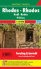


Rhodes Kompass 248
Rhodes at 1:50, 000 on a double-sided map from Kompass printed on sturdy waterproof and tear-resistant plastic paper, with street plan of Rhodos Town, an enlargement for its historic centre, a plan of Lindos, etc.The map divides the island north/south with a good overlap between the sides. The islands of Symi, Chalki and Alimia are included as insets. All place names are in both Greek and Latin alphabet and in large, easy to read print. Topography is shown by contours at 50m intervals, with colouring indicating various types of vegetation. Road network includes cart tracks and shows locations of fuel supplies. Both local country paths and highlighted hiking trails (i.e. routes mostly waymarked) indicate steep sections. A wide range of symbols show various places of interest and
tourist facilities, including selected hotels, campsites and youth hostels, sport and recreational facilities, nudist beaches, surfing and diving sites, etc. The map has no geographical coordinates. Map legend includes English.Also provided are: a street plan of town of Rhodos and an enlargement for its historic centre - both plans are annotated with accommodation and various places of interest (names are given in German); a street plan of Lindos with a plan of its Acropolis archaeological site: plus a small map of the Aegean showing ferry connections between the Greek islands.
tourist facilities, including selected hotels, campsites and youth hostels, sport and recreational facilities, nudist beaches, surfing and diving sites, etc. The map has no geographical coordinates. Map legend includes English.Also provided are: a street plan of town of Rhodos and an enlargement for its historic centre - both plans are annotated with accommodation and various places of interest (names are given in German); a street plan of Lindos with a plan of its Acropolis archaeological site: plus a small map of the Aegean showing ferry connections between the Greek islands.

Product Description
Reviews/Comments
Add New
Intelligent Comparison
Archived Product
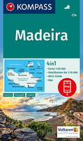
Madeira Kompass 234 Stanfords
£13.99
Vouchers
No voucher codes found.
Do you know a voucher code for this product or supplier? Add it to Insights for others to use.
Do you know a voucher code for this product or supplier? Add it to Insights for others to use.
 Denmark