More From Contributor

£10.99
Montreal on an indexed, double-sided, waterproof & tear-resistant Fast Track map presenting the city’s central districts at 1:26, 000, with an enlargement showing in greater detail Montreal’s downtown area at 1:15, 000, plus a road map of the surrounding district at 1:250, 000. Street plans from the Map Art / Canadian Cartographics Corporation / JDM Géo publishing group are usually produced at scales around 1:25, 000 to 1:35, 000 with smaller towns often shown at more detailed scales. All plans have street indexes. Plans of larges cities usually include an enlargement for the downtown area. Plans grouping together several smaller towns often have an overview map showing the whole of the relevant region. The plans have colouring to indicate commercial, institutional or industrial use, etc. Main traffic arteries are highlighted & one way streets are marked. A range of symbols shows, as appropriate, parking facilities, bus terminals, metro and/or railway stations, various public facilities & services, places of interest, recreational centres, etc. Map legends for cities & towns in the French speaking part of the country are sometimes in French only. To see the list of currently available Canadian street plans & pocket atlases form the Map Art / Canadian Cartographics Corporation / JDM Géo publishing group, including waterproof & tear-resistant Fast Track titles, please click on the series link. ...
Archived Product
£8.99
Québec City at 1:25, 000 on a double-sided, indexed street plan with an enlargement showing the city centre in greater detail at 1:15, 000. Coverage

Includes::
Boischatel, Lac-Beauport, L` Ancienne-Loretteville, Lévis & Saint-Augustin-de-Desmaures. Street plans from the Map Art / Canadian Cartographics Corporation / JDM Géo publishing group are usually produced at scales around 1:25, 000 to 1:35, 000 with smaller towns often shown at more detailed scales. All plans have street indexes. Plans of larges cities usually include an enlargement for the downtown area. Plans grouping together several smaller towns often have an overview map showing the whole of the relevant region. The plans have colouring to indicate commercial, institutional or industrial use, etc. Main traffic arteries are highlighted & one way streets are marked. A range of symbols shows, as appropriate, parking facilities, bus terminals, metro and/or railway stations, various public facilities & services, places of interest, recreational centres, etc. Map legends for cities & towns in the French speaking part of the country are sometimes in French only. To see the list of currently available Canadian street plans & pocket atlases form the Map Art / Canadian Cartographics Corporation / JDM Géo publishing group, including waterproof & tear-resistant Fast Track titles, please click on the series link.

...
Archived Product
£5.99
Quebec on a large, indexed road map at 1:1, 100, 000 from Michelin, with street plans of central Montreal, Quebec City’s Old Town & Trois-Rivières, plus panels highlighting places of interest and/or sightseeing routes in Montreal & in four recommended regions. Coverage

Includes::
New Brunswick & Prince Edward Isl&, plus most of Nova Scotia & Maine. Topography is presented by unobtrusive relief shading, with spot heights & plenty of names of rivers & lakes. The province’s numerous national parks & other protected areas are prominently highlighted. Road network indicates toll routes, motorway services, picnic areas, etc. Scenic routes are highlighted & driving distances, shown in kilometres (in miles with the US), are marked on main highways. Railway lines are not included but ferry connections are marked. Various places of interest are highlighted, indicating sites included in the Michelin’s Green Guide to Quebec Province, campsites, etc. The index is next to the map. Map legend is in English & French. Street plans naming important buildings cover central Montreal, the Vieux Québec & Trois-Rivières. Panels with sightseeing information, including star grading of recommendations, show Greater Montreal, plus with additional special touring routes: the region around Montreal, the area north-west of Quebec City, the right bank of the St. Lawrence Estuary with the Gaspé Peninsula, plus the Côte-Nord of the estuary. Also provided is a distance table.

...
Archived Product
£14.99
Quebec in the Green Guide series from Michelin; detailed guides exploring the major sights & attractions of a range of cities, regions & countries. Drawing on a long publishing history, Michelin guides are renowned for their individual ‘star rating’, ranking restaurants, sights & attractions. Listings in each guide are organised alphabetically, allowing readers to access information quickly as well as being designed for practical use on the road. With an emphasis on cultural activities & history, each sight is graded & has extensive background information. Practical visitor information is clearly highlighted with symbols. Predominantly recognised for their extensive coverage of French regions (shown on our website in a separate series), the Green Guides also cover international destinations. An extensive introductory section on planning your trip provides information on when & where to go, useful pre-trip information, getting there, where to stay & eat & what to do & see. There are also individual sections on Nature, History & Art ad Culture & a selection of driving tours of the area. Fold-out maps at the front & back of the book give an overview of the area covered by the guide. The structure of each guide varies depending on the type of destination. National & regional guides cover regions alphabetically, each with their own accommodation, sights & food & drink listings, while City guides cover sights alphabetically with one city-wide section for listings. Accommodation & food & drink listings are both concise & comprehensive, aiming to cater for all budgets & tastes. Both sights & listings often include information specific to travelling with kids. Each of the places covered in the guide is listed alphabetically & three Michelin star ratings
- highly recommended, recommended & interesting, which have been used for more than 100 years
- help readers identify places of interest, restaurants & notable local attractions. Individual listings include principal sights for each city or town, local walking & driving tours in addition to tips on local excursions. There is also an ‘address book’ information box in each section including recommendations for the best restaurants & accommodation in the area, as well as any relevant leisure activities. A series of overview regional & city plans also helps navigation & orientation for each region.

...
Archived Product
£8.95
Double-sided map of Quebec Province, part of a series of maps of Canadian provinces from the Vancouver-based ITMB, with topography presented by altitude colouring rather than by relief shading. Unlike most maps of the province, this title covers all of it, with the southern part (to just below 52 ...
Archived Product
£10.95
Pocket road atlas of Quebec Province, one of the titles in a series of handy size, indexed road atlases of Canadian provinces, with numerous street plans of main cities & towns. Each atlas contains road mapping at scales similar to or better than in corresponding folded maps, providing a comprehensive picture of the road network, with detailed road grading, rest areas & service centres, intermediate driving distances, etc. Also shown are railway lines, time zone boundaries, & different administrative divisions of each province. Extensive overprint highlights numerous places of interest, including national/provincial parks & wildlife reserves, different types of campsites, sport & recreational facilities, etc. Topography is indicated by relief shading with spot heights. Each title

Includes::
several street plans of main cities in the province showing one way streets & indicating public transport stations & various places of interest & facilities. In this title: the southern part of the province is covered at 1;800, 000, with the adjoining areas at 1:2, 500, 000 (see our coverage image). Enlargements at 1:250, 000 cover: Montr

...
Archived Product
£7.99
Quebec’s Cantons de l’ Est on a double-sided map presenting individual street plans at 1:35, 000 of Sherbrooke, Drummondville, Encadré, Trois-Rivières, Thetford Mines, Granby, Victoriaville & Saint-Hyacinthe, plus on the reverse a road map whole area at 1:230, 000. Both the road map & each of the street plans are indexed. Street plans from the Map Art / Canadian Cartographics Corporation / JDM Géo publishing group are usually produced at scales around 1:25, 000 to 1:35, 000 with smaller towns often shown at more detailed scales. All plans have street indexes. Plans of larges cities usually include an enlargement for the downtown area. Plans grouping together several smaller towns often have an overview map showing the whole of the relevant region. The plans have colouring to indicate commercial, institutional or industrial use, etc. Main traffic arteries are highlighted & one way streets are marked. A range of symbols shows, as appropriate, parking facilities, bus terminals, metro and/or railway stations, various public facilities & services, places of interest, recreational centres, etc. Map legends for cities & towns in the French speaking part of the country are sometimes in French only. To see the list of currently available Canadian street plans & pocket atlases form the Map Art / Canadian Cartographics Corporation / JDM Géo publishing group, including waterproof & tear-resistant Fast Track titles, please click on the series link. ...
Archived Product
£5.95
Quebrada de Humahuaca Valley at 1:590, 000 approx. in a series of maps of popular sightseeing routes in the northern provinces of Argentina from Asiru Editorial, presenting the region on one side with altitude coluring & on the reverse as a satellite image to provide a very clear impression of the topography. The map covers an area north of San Salvador de Jujuy, highlighting the route along the provincial highway No. to Abra Pampa. Maps in Asiru series have on one side of a map with altitude colouring & plenty of spot heights & names of various mountain ranges, valleys, rivers & lakes, salt flats, nature reserves, etc. Locations along the highlighted route & selected other places are annotated with their altitude above the sea level. The map shows local road & rail networks, distinguishing between paved & unpaved roads, showing driving distances, & marking locations of fuel supplies. A separate diagram of the road network shows main towns & villages annotated with facilities & services provided in them. The maps have latitude & longitude margin ticks. On the reverse the same area is shown as a satellite image to provide an alternative view of the region ...
Archived Product
£29.95
One of the maps in the topographic survey of Peru from the country’s national survey organization, Instituto Geográfico Nacional. Contours are at 25m intervals & colouring/symbols indicate different types of terrain & vegetation. Some of the maps may contain small blank spaces representing as yet unmapped areas. Each sheet covers 30’ latitude by 30’ longitude. The maps have a 1km UTM grid & margin ticks for latitude & longitude at intervals of 1’. Publication dates vary; most maps were published in 1960s to 1990s, with some sheets revised more recently. Map legend is in Spanish only, except in the more recent editions which also include English. ...
Archived Product
£3.99
The Lonely Planet Quechua Phrasebook is not only an extensive list of useful phrases, but also an ideal tool to start getting to grips with a language & beginning two-way communication. Containing excellent sections on language basics such as numbers, question phrases, dates, phrase construction, grammar & pronunciation, as well as containing concise but well-rounded two-way dictionaries, Lonely Planet phrasebooks enable you to quickly & confidently construct your own phrases in addition to those given. The given phrases cover all the essential travel & tourism categories such as transport, communications, business meetings & accommodation, as well as in-depth categories such as health, food & social interaction. The phrasebooks are designed to enable more than just simple question-answer communication, allowing the start of two-way conversations ...
Archived Product

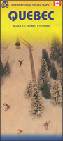
Quebec Province ITMB

Double-sided map of Quebec Province, part of a series of maps of Canadian provinces from the Vancouver-based ITMB, with topography presented by altitude colouring rather than by relief shading. Unlike most maps of the province, this title covers all of it, with the southern part (to just below 52º) presented at 1:1, 000, 000 and the northern half at 1:1, 750, 000 extending all the way to the Hudson Straight. The easternmost part of the province, the Côte-Nord along the northern shore of the Gulf of St. Lawrence is shown on an inset at a reduced scale of 1:3, 600, 000.Road and rail networks are shown on a clear base with numerous national or regional parks and nature reserves prominently marked. Symbols highlight various places of interest, sport and recreational facilities, etc.
In remote areas locations of airfields are also indicated. The map has a latitude and longitude grid at intervals of 1º and an index of localities. The side with southern Quebec also contains an enlargement showing in greater detail the road network in the Montreal – Laval area.To see other titles in this series please click on the series link.
RIP - This product is no longer available on our network. It was last seen on 25.09.2019

This page now acts as a permanent archive for this product. Add more information using the comments box below to ensure it can still be found by future generations.

Use our search facility to see if it is available from an alternative contributor.
  • External links may include paid for promotion
  • Availability: Out Of Stock
  • Supplier: Stanfords
  • SKU: 9781553418092
Availability: In Stock
£9.99

Product Description

Double-sided map of Quebec Province, part of a series of maps of Canadian provinces from the Vancouver-based ITMB, with topography presented by altitude colouring rather than by relief shading. Unlike most maps of the province, this title covers all of it, with the southern part (to just below 52º) presented at 1:1, 000, 000 & the northern half at 1:1, 750, 000 extending all the way to the Hudson Straight. The easternmost part of the province, the Côte-Nord along the northern shore of the Gulf of St. Lawrence is shown on an inset at a reduced scale of 1:3, 600, 000. Road & rail networks are shown on a clear base with numerous national or regional parks & nature reserves prominently marked. Symbols highlight various places of interest, sport & recreational facilities, etc. In remote areas locations of airfields are also indicated. The map has a latitude & longitude grid at intervals of 1º & an index of localities. The side with southern Quebec also contains an enlargement showing in greater detail the road network in the Montreal – Laval area. To see other titles in this series please click on the series link.

Reviews/Comments

Add New

Intelligent Comparison

Oooops!
We couldn't find anything!
Perhaps this product's unique.... Or perhaps we are still looking for comparisons!
Click to bump this page and we'll hurry up.

Price History

Vouchers

No voucher codes found.
Do you know a voucher code for this product or supplier? Add it to Insights for others to use.

Facebook

Jargon Buster

Network - A link and communication between things. Often computers or people.
Road - a manmade lane or a path that is used to speed up travel.
Altitude - Something that can be quite high in relation to sea or ground level.
Regional - An adjective to describe a set geographic area.

Supplier Information

Stanfords
Stanfords was established in 1853 and opened their iconic Covent Garden flagship store in 1901. They have become the top retailer of maps, travel books and accessories in the UK and arguably offer the largest selection of maps and travel books worldwide. Famous names such as Captain Robert Falcon Scott, Ranulph Fiennes and Michael Palin have purchased from Stanfords. They now have a shop in Bristol and both stores together with other venues operate a calendar of events including talks, book signings and exhibitions. As a specialist map retailer, the map selection is comprehensive and includes road maps, street maps and walking maps from worldwide destinations, as well as a selection of world atlases and wall maps. Books include travel guides and travel literature. Stanfords also stock globes, from miniatures made of blue marble to magnificent floor-standing globes. The website features a selection of interesting articles on travel topics.
Page Updated: 2023-11-12 20:15:36

Community Generated Product Tags

Oh No! The productWIKI community hasn't generated any tags for this product yet!
Menu