More From Contributor
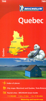
£26.99
Premium Material, 100% plastic free made from 100% BPA-free food-grade silicone, que Bottle is 100% plastic-free, making it safe for people & the planet. Unlike metal or plastic containers, silicone WILL NOT change the taste of your water. It`s the water bottle that has the best qualities of glass & metal, with the added benefit of being flexible, light, & shatter resistant.que Bottle is lightweight & compact, taste & odor free, stain & bacteria resistant, dishwasher safe, & leakproof.que Bottles are the only collapsible water bottles that are functional & fashionable. Its unique spiral design compresses bottles into half size without compromising the good looks. que Bottles can easily fit into virtually any bags, making them perfect for traveling, outdoors & everyday life. ...
Archived Product
£13.99
ITMB’s mapping of Ontario & Quebec provinces presented in a handy-size A5 paperback atlas with additional street plans & transit network diagrams of Toronto & Montreal. The whole of each province is covered, with the northern regions shown at less detailed scales than the more densely populated south. Southern Ontario is shown at 1:550, 000, with the Sault Ste. Marie area at 1:750, 000 & the rest of the province at 1:1, 500, 000. Additional plates present a 6-page street plan of Toronto’s central districts including The Beaches, a map of the environs including access to the Pearson International Airport, plus a Toronto Rapid Transit diagram. Southern Quebec province is covered at 1:850, 000, with the northern part of the province at 1:1, 700, 000, plus the northern shore of the Gulf of St. Lawrence at 1:2, 000, 000. A 6-page street plan of Montreal’s central districts is accompanied by a regional map which

Includes::
Laval, plus a transit network diagram. Road & rail networks are shown on a base with altitude colouring (elevation in feet). Driving distances are marked on main & selected secondary routes. In the northern parts of the two provinces the atlas indicates which locations are accessible by scheduled air services. Symbols indicate various places of interest & facilities. National & provincial parks & recreational areas are highlighted; in the northern regions numerous small rivers & lakes are named. The atlas has an index & on most pages latitude & longitude are indicated by margin ticks at 1º intervals. To see the list of other ITMB maps in this series please click on the series link.

...
Archived Product
£23.99
Street atlas of Quebec City & environs, including Beauport, Beaupre, Bernieres, Boischatel, Bourg-Royal, Breakeyville, Cap-Route, Cap-Sante, Charlesbourg, Charny, Chateau-Richer, Donnacona & other locations. The atlas is part of an extensive coverage of Canadian cities & towns from the country’s largest map publisher, Map Art. The mapping is usually at 1:25, 000 or 1:31, 250. Colouring distinguishes general build-up areas, shopping centres, public buildings & institutions, historical sites & places of interest, parks, etc. One way streets & pedestrian zones are indicated & a wide range of symbols shows parking facilities, bus terminals, metro and/or railway stations, various public facilities & services, places of interest, recreational centres, etc. Local neighbourhoods are named & municipal & quadrant boundaries are marked. In titles covering more than one city or town, each section is accompanied by overview maps indicating areas covered by the street plans. Each title has a full street index for all localities covered by it. Map legend is either bilingual in English & French or in English only.* Please note:* following a number changes among Canadian cartographic publishers maps previously published by Map Art Publishing may now be available under one of the following imprints: Map Art, Canadian Cartographics Corporation or JDM Géo Inc. Within a series, therefore, some titles may still be published as Map Art whilst others will be available as Canadian Cartographics Corporation or JDM Géo Inc. ...
Archived Product
£10.99
Montreal on an indexed, double-sided, waterproof & tear-resistant Fast Track map presenting the city’s central districts at 1:26, 000, with an enlargement showing in greater detail Montreal’s downtown area at 1:15, 000, plus a road map of the surrounding district at 1:250, 000. Street plans from the Map Art / Canadian Cartographics Corporation / JDM Géo publishing group are usually produced at scales around 1:25, 000 to 1:35, 000 with smaller towns often shown at more detailed scales. All plans have street indexes. Plans of larges cities usually include an enlargement for the downtown area. Plans grouping together several smaller towns often have an overview map showing the whole of the relevant region. The plans have colouring to indicate commercial, institutional or industrial use, etc. Main traffic arteries are highlighted & one way streets are marked. A range of symbols shows, as appropriate, parking facilities, bus terminals, metro and/or railway stations, various public facilities & services, places of interest, recreational centres, etc. Map legends for cities & towns in the French speaking part of the country are sometimes in French only. To see the list of currently available Canadian street plans & pocket atlases form the Map Art / Canadian Cartographics Corporation / JDM Géo publishing group, including waterproof & tear-resistant Fast Track titles, please click on the series link. ...
Archived Product
£8.99
Québec City at 1:25, 000 on a double-sided, indexed street plan with an enlargement showing the city centre in greater detail at 1:15, 000. Coverage

Includes::
Boischatel, Lac-Beauport, L` Ancienne-Loretteville, Lévis & Saint-Augustin-de-Desmaures. Street plans from the Map Art / Canadian Cartographics Corporation / JDM Géo publishing group are usually produced at scales around 1:25, 000 to 1:35, 000 with smaller towns often shown at more detailed scales. All plans have street indexes. Plans of larges cities usually include an enlargement for the downtown area. Plans grouping together several smaller towns often have an overview map showing the whole of the relevant region. The plans have colouring to indicate commercial, institutional or industrial use, etc. Main traffic arteries are highlighted & one way streets are marked. A range of symbols shows, as appropriate, parking facilities, bus terminals, metro and/or railway stations, various public facilities & services, places of interest, recreational centres, etc. Map legends for cities & towns in the French speaking part of the country are sometimes in French only. To see the list of currently available Canadian street plans & pocket atlases form the Map Art / Canadian Cartographics Corporation / JDM Géo publishing group, including waterproof & tear-resistant Fast Track titles, please click on the series link.

...
Archived Product
£14.99
Quebec in the Green Guide series from Michelin; detailed guides exploring the major sights & attractions of a range of cities, regions & countries. Drawing on a long publishing history, Michelin guides are renowned for their individual ‘star rating’, ranking restaurants, sights & attractions. Listings in each guide are organised alphabetically, allowing readers to access information quickly as well as being designed for practical use on the road. With an emphasis on cultural activities & history, each sight is graded & has extensive background information. Practical visitor information is clearly highlighted with symbols. Predominantly recognised for their extensive coverage of French regions (shown on our website in a separate series), the Green Guides also cover international destinations. An extensive introductory section on planning your trip provides information on when & where to go, useful pre-trip information, getting there, where to stay & eat & what to do & see. There are also individual sections on Nature, History & Art ad Culture & a selection of driving tours of the area. Fold-out maps at the front & back of the book give an overview of the area covered by the guide. The structure of each guide varies depending on the type of destination. National & regional guides cover regions alphabetically, each with their own accommodation, sights & food & drink listings, while City guides cover sights alphabetically with one city-wide section for listings. Accommodation & food & drink listings are both concise & comprehensive, aiming to cater for all budgets & tastes. Both sights & listings often include information specific to travelling with kids. Each of the places covered in the guide is listed alphabetically & three Michelin star ratings
- highly recommended, recommended & interesting, which have been used for more than 100 years
- help readers identify places of interest, restaurants & notable local attractions. Individual listings include principal sights for each city or town, local walking & driving tours in addition to tips on local excursions. There is also an ‘address book’ information box in each section including recommendations for the best restaurants & accommodation in the area, as well as any relevant leisure activities. A series of overview regional & city plans also helps navigation & orientation for each region.

...
Archived Product
£8.95
Double-sided map of Quebec Province, part of a series of maps of Canadian provinces from the Vancouver-based ITMB, with topography presented by altitude colouring rather than by relief shading. Unlike most maps of the province, this title covers all of it, with the southern part (to just below 52 ...
Archived Product
£9.99
Double-sided map of Quebec Province, part of a series of maps of Canadian provinces from the Vancouver-based ITMB, with topography presented by altitude colouring rather than by relief shading. Unlike most maps of the province, this title covers all of it, with the southern part (to just below 52º) presented at 1:1, 000, 000 & the northern half at 1:1, 750, 000 extending all the way to the Hudson Straight. The easternmost part of the province, the Côte-Nord along the northern shore of the Gulf of St. Lawrence is shown on an inset at a reduced scale of 1:3, 600, 000. Road & rail networks are shown on a clear base with numerous national or regional parks & nature reserves prominently marked. Symbols highlight various places of interest, sport & recreational facilities, etc. In remote areas locations of airfields are also indicated. The map has a latitude & longitude grid at intervals of 1º & an index of localities. The side with southern Quebec also contains an enlargement showing in greater detail the road network in the Montreal – Laval area. To see other titles in this series please click on the series link. ...
Archived Product
£10.95
Pocket road atlas of Quebec Province, one of the titles in a series of handy size, indexed road atlases of Canadian provinces, with numerous street plans of main cities & towns. Each atlas contains road mapping at scales similar to or better than in corresponding folded maps, providing a comprehensive picture of the road network, with detailed road grading, rest areas & service centres, intermediate driving distances, etc. Also shown are railway lines, time zone boundaries, & different administrative divisions of each province. Extensive overprint highlights numerous places of interest, including national/provincial parks & wildlife reserves, different types of campsites, sport & recreational facilities, etc. Topography is indicated by relief shading with spot heights. Each title

Includes::
several street plans of main cities in the province showing one way streets & indicating public transport stations & various places of interest & facilities. In this title: the southern part of the province is covered at 1;800, 000, with the adjoining areas at 1:2, 500, 000 (see our coverage image). Enlargements at 1:250, 000 cover: Montr

...
Archived Product
£7.99
Quebec’s Cantons de l’ Est on a double-sided map presenting individual street plans at 1:35, 000 of Sherbrooke, Drummondville, Encadré, Trois-Rivières, Thetford Mines, Granby, Victoriaville & Saint-Hyacinthe, plus on the reverse a road map whole area at 1:230, 000. Both the road map & each of the street plans are indexed. Street plans from the Map Art / Canadian Cartographics Corporation / JDM Géo publishing group are usually produced at scales around 1:25, 000 to 1:35, 000 with smaller towns often shown at more detailed scales. All plans have street indexes. Plans of larges cities usually include an enlargement for the downtown area. Plans grouping together several smaller towns often have an overview map showing the whole of the relevant region. The plans have colouring to indicate commercial, institutional or industrial use, etc. Main traffic arteries are highlighted & one way streets are marked. A range of symbols shows, as appropriate, parking facilities, bus terminals, metro and/or railway stations, various public facilities & services, places of interest, recreational centres, etc. Map legends for cities & towns in the French speaking part of the country are sometimes in French only. To see the list of currently available Canadian street plans & pocket atlases form the Map Art / Canadian Cartographics Corporation / JDM Géo publishing group, including waterproof & tear-resistant Fast Track titles, please click on the series link. ...
Archived Product

Quebec Michelin

Quebec on a large, indexed road map at 1:1, 100, 000 from Michelin, with street plans of central Montreal, Quebec City’s Old Town and Trois-Rivières, plus panels highlighting places of interest and/or sightseeing routes in Montreal and in four recommended regions. Coverage includes New Brunswick and Prince Edward Island, plus most of Nova Scotia and Maine.Topography is presented by unobtrusive relief shading, with spot heights and plenty of names of rivers and lakes. The province’s numerous national parks and other protected areas are prominently highlighted. Road network indicates toll routes, motorway services, picnic areas, etc. Scenic routes are highlighted and driving distances, shown in kilometres (in miles with the US), are marked on main highways. Railway lines are
not included but ferry connections are marked. Various places of interest are highlighted, indicating sites included in the Michelin’s Green Guide to Quebec Province, campsites, etc. The index is next to the map. Map legend is in English and French.Street plans naming important buildings cover central Montreal, the Vieux Québec and Trois-Rivières. Panels with sightseeing information, including star grading of recommendations, show Greater Montreal, plus with additional special touring routes: the region around Montreal, the area north-west of Quebec City, the right bank of the St. Lawrence Estuary with the Gaspé Peninsula, plus the Côte-Nord of the estuary. Also provided is a distance table.
RIP - This product is no longer available on our network. It was last seen on 25.09.2019

This page now acts as a permanent archive for this product. Add more information using the comments box below to ensure it can still be found by future generations.

Use our search facility to see if it is available from an alternative contributor.
  • External links may include paid for promotion
  • Availability: Out Of Stock
  • Supplier: Stanfords
  • SKU: 9782067211919
Availability: In Stock
£5.99

Product Description

Quebec on a large, indexed road map at 1:1, 100, 000 from Michelin, with street plans of central Montreal, Quebec City’s Old Town & Trois-Rivières, plus panels highlighting places of interest and/or sightseeing routes in Montreal & in four recommended regions. Coverage

Includes::
New Brunswick & Prince Edward Isl&, plus most of Nova Scotia & Maine. Topography is presented by unobtrusive relief shading, with spot heights & plenty of names of rivers & lakes. The province’s numerous national parks & other protected areas are prominently highlighted. Road network indicates toll routes, motorway services, picnic areas, etc. Scenic routes are highlighted & driving distances, shown in kilometres (in miles with the US), are marked on main highways. Railway lines are not included but ferry connections are marked. Various places of interest are highlighted, indicating sites included in the Michelin’s Green Guide to Quebec Province, campsites, etc. The index is next to the map. Map legend is in English & French. Street plans naming important buildings cover central Montreal, the Vieux Québec & Trois-Rivières. Panels with sightseeing information, including star grading of recommendations, show Greater Montreal, plus with additional special touring routes: the region around Montreal, the area north-west of Quebec City, the right bank of the St. Lawrence Estuary with the Gaspé Peninsula, plus the Côte-Nord of the estuary. Also provided is a distance table.

Reviews/Comments

Add New

Intelligent Comparison

Oooops!
We couldn't find anything!
Perhaps this product's unique.... Or perhaps we are still looking for comparisons!
Click to bump this page and we'll hurry up.

Price History

Vouchers

No voucher codes found.
Do you know a voucher code for this product or supplier? Add it to Insights for others to use.

Facebook

Jargon Buster

star - A giant ball of plasma held together by gravity.
Network - A link and communication between things. Often computers or people.
Large - something that takes up more space than normal.
Road - a manmade lane or a path that is used to speed up travel.

Supplier Information

Stanfords
Stanfords was established in 1853 and opened their iconic Covent Garden flagship store in 1901. They have become the top retailer of maps, travel books and accessories in the UK and arguably offer the largest selection of maps and travel books worldwide. Famous names such as Captain Robert Falcon Scott, Ranulph Fiennes and Michael Palin have purchased from Stanfords. They now have a shop in Bristol and both stores together with other venues operate a calendar of events including talks, book signings and exhibitions. As a specialist map retailer, the map selection is comprehensive and includes road maps, street maps and walking maps from worldwide destinations, as well as a selection of world atlases and wall maps. Books include travel guides and travel literature. Stanfords also stock globes, from miniatures made of blue marble to magnificent floor-standing globes. The website features a selection of interesting articles on travel topics.
Page Updated: 2023-11-12 20:15:36

Community Generated Product Tags

Oh No! The productWIKI community hasn't generated any tags for this product yet!
Menu