More From Contributor
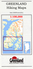
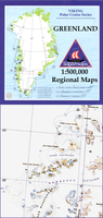
£25.00
FIFTY years ago the last British-built transatlantic liner was launched. Christened by HM the Queen on 20 September 1967, the 963ft-long vessel was named Queen Elizabeth 2. By the end of that same day, she was already known by her famous nickname: QE2. Fast, smart & sleek, QE2 sailed over 5.6 million miles & carried more than 2.5 million passengers during a magnificent career spanning nearly forty years. Put simply, she carried more people further than any ship before her & remains the longest serving express liner in history. Having sailed both as a liner & as a cruise ship, served her country in the Falklands conflict & undergone multiple makeovers, she also has one of the most fascinating histories of any vessel & remains one of the best loved & most celebrated. With stories from captains, crew & passengers, & an unparalleled collection of photographs, Chris Frame & Rachelle Cross bring the majestic QE2 to life in this commemorative tribute. ...
Archived Product
£12.95
Qegertarsuaq Hiking Map No. 15 at 1: 100, 000 part of a series covering the Coastal areas of Greenland at 1:100, 000 or 1:75, 000 of GPS compatible contoured topographic maps from Greenland Tourism, indicating both recommended hiking trails & snowmobile routes, plus camping places, youth hostels, etc. Contours lines are at 25m intervals & additional altitude colouring. The maps provide a very detailed picture of the terrain, showing topographic features such as rivers & streams with fords, sand or gravel shoreline, marshes, boulder fields, etc. Recommended hiking trail are marked, as well as snowmobile routes. The maps show local settlements & connecting roads & tracks. Symbols indicate locations of heliports, general stores, medical facilities, youth hostels or huts, camping terrain, viewpoints, etc.A grid gives UTM co-ordinates plus latitude in steps of 5' & longitude in 10'. The maps are printed on waterproof & tear-resistant paper. Map legend

Includes::
English. On the reverse selected titles have notes, in English, with advice on hiking in Greenl&, as well as descriptions of the area, including plans of main settlements highlighting important buildings & institutions. Some maps are double-sided to provide a wider coverage.

...
Archived Product
£16.95
Qegertarsuaq Hiking Map No. 15 at 1: 100, 000 part of a series covering the Coastal areas of Greenland at 1:100, 000 or 1:75, 000 of GPS compatible contoured topographic maps from Greenland Tourism, indicating both recommended hiking trails & snowmobile routes, plus camping places, youth hostels, etc. Contours lines are at 25m intervals & additional altitude colouring. The maps provide a very detailed picture of the terrain, showing topographic features such as rivers & streams with fords, sand or gravel shoreline, marshes, boulder fields, etc. Recommended hiking trail are marked, as well as snowmobile routes. The maps show local settlements & connecting roads & tracks. Symbols indicate locations of heliports, general stores, medical facilities, youth hostels or huts, camping terrain, viewpoints, etc.A grid gives UTM co-ordinates plus latitude in steps of 5` & longitude in 10`. The maps are printed on waterproof & tear-resistant paper. Map legend

Includes::
English. On the reverse selected titles have notes, in English, with advice on hiking in Greenl&, as well as descriptions of the area, including plans of main settlements highlighting important buildings & institutions. Some maps are double-sided to provide a wider coverage.

...
Archived Product
£13.95
Topographic survey of Greenland at 1:250, 000 from Sagamaps in a series which along the western coast extends past Thule to the latitude of 78°, plus covers selected areas of the east coast including the Stauning Alps. Relief is shown by contours at 50m intervals, augmented by frequent spot heights. Main peaks are named, along with many other physical features, e.g. bays & islands. Glaciers, moraine & low-lying coastal plains are also indicated & contours continue for a limited extent into the icecap region. The maps show settlements, roads, airstrips & heliports, anchorages & selected other landmarks. Lines of longitude & latitude are drawn at 1° & 15` intervals respectively. Map legend which

Includes::
English is provided in a separate sheet. Saga’s topographic mapping of Greenland at 1:250, 000 is available either as 22 smaller sheets, sold separately or in sets of four maps, plus as three larger maps covering the western coast up to approx 65°. Selected titles are also published with a historical guide on the reverse illustrated with old photos, drawings & maps; all the text is in English. To see the full list of titles in this series please click on the series link.

...
Archived Product
£22.95
Topographic survey of Greenland at 1:250, 000 from Sagamaps in a series which along the western coast extends past Thule to the latitude of 78°, plus covers selected areas of the east coast including the Stauning Alps. Relief is shown by contours at 50m intervals, augmented by frequent spot heights. Main peaks are named, along with many other physical features, e.g. bays & islands. Glaciers, moraine & low-lying coastal plains are also indicated & contours continue for a limited extent into the icecap region. The maps show settlements, roads, airstrips & heliports, anchorages & selected other landmarks. Lines of longitude & latitude are drawn at 1° & 15` intervals respectively. Map legend which

Includes::
English is provided in a separate sheet. Saga’s topographic mapping of Greenland at 1:250, 000 is available either as 22 smaller sheets, sold separately or in sets of four maps, plus as three larger maps covering the western coast up to approx 65°. Selected titles are also published with a historical guide on the reverse illustrated with old photos, drawings & maps; all the text is in English. To see the full list of titles in this series please click on the series link.

...
Archived Product
£13.95
Topographic survey of Greenland at 1:250, 000 from Sagamaps in a series which along the western coast extends past Thule to the latitude of 78°, plus covers selected areas of the east coast including the Stauning Alps. Relief is shown by contours at 50m intervals, augmented by frequent spot heights. Main peaks are named, along with many other physical features, e.g. bays & islands. Glaciers, moraine & low-lying coastal plains are also indicated & contours continue for a limited extent into the icecap region. The maps show settlements, roads, airstrips & heliports, anchorages & selected other landmarks. Lines of longitude & latitude are drawn at 1° & 15` intervals respectively. Map legend which

Includes::
English is provided in a separate sheet. Saga’s topographic mapping of Greenland at 1:250, 000 is available either as 22 smaller sheets, sold separately or in sets of four maps, plus as three larger maps covering the western coast up to approx 65°. Selected titles are also published with a historical guide on the reverse illustrated with old photos, drawings & maps; all the text is in English. To see the full list of titles in this series please click on the series link.

...
Archived Product
£16.50
One of the titles in a series of contoured physical maps covering the coastal areas of Greenl&. The maps have the same cartography as the 1:250, 000 series by this publisher, reproduced here at half the original scale. The reduction means that some place names, symbols & fine detail are harder to read than on the original 1:250, 000 series. Main peaks, bays, channels etc. are named, & settlements, airstrips, & anchorages are shown. Glaciers, moraine & low-lying coastal plains are also distinguished. Lines of longitude & latitude are drawn at 1° & 15` intervals respectively. There is no map legend. ...
Archived Product
£15.95
Topographic survey of Greenland at 1:250, 000 from Sagamaps in a series which along the western coast extends past Thule to the latitude of 78°, plus covers selected areas of the east coast including the Stauning Alps. Relief is shown by contours at 50m intervals, augmented by frequent spot heights. Main peaks are named, along with many other physical features, e.g. bays & islands. Glaciers, moraine & low-lying coastal plains are also indicated & contours continue for a limited extent into the icecap region. The maps show settlements, roads, airstrips & heliports, anchorages & selected other landmarks. Lines of longitude & latitude are drawn at 1° & 15` intervals respectively. Map legend which

Includes::
English is provided in a separate sheet. Saga’s topographic mapping of Greenland at 1:250, 000 is available either as 22 smaller sheets, sold separately or in sets of four maps, plus as three larger maps covering the western coast up to approx 65°. Selected titles are also published with a historical guide on the reverse illustrated with old photos, drawings & maps; all the text is in English. To see the full list of titles in this series please click on the series link.

...
Archived Product
£13.95
Topographic survey of Greenland at 1:250, 000 from Sagamaps in a series which along the western coast extends past Thule to the latitude of 78°, plus covers selected areas of the east coast including the Stauning Alps. Relief is shown by contours at 50m intervals, augmented by frequent spot heights. Main peaks are named, along with many other physical features, e.g. bays & islands. Glaciers, moraine & low-lying coastal plains are also indicated & contours continue for a limited extent into the icecap region. The maps show settlements, roads, airstrips & heliports, anchorages & selected other landmarks. Lines of longitude & latitude are drawn at 1° & 15` intervals respectively. Map legend which

Includes::
English is provided in a separate sheet. Saga’s topographic mapping of Greenland at 1:250, 000 is available either as 22 smaller sheets, sold separately or in sets of four maps, plus as three larger maps covering the western coast up to approx 65°. Selected titles are also published with a historical guide on the reverse illustrated with old photos, drawings & maps; all the text is in English. To see the full list of titles in this series please click on the series link.

...
Archived Product
£24.95
A street plan of Qom with names of major streets marked in Latin script as well as Arabic. All other text on map is in Arabic only. Museums, historical monuments, hotels, public buildings, mosques & churches are highlighted. Index to map is only in Persian but key to symbols is in English as well. ...
Archived Product

Qeqertarsuup Tunua

One of the titles in a series of contoured physical maps covering the coastal areas of Greenland. The maps have the same cartography as the 1:250, 000 series by this publisher, reproduced here at half the original scale. The reduction means that some place names, symbols and fine detail are harder to read than on the original 1:250, 000 series.Main peaks, bays, channels etc. are named, and settlements, airstrips, and anchorages are shown. Glaciers, moraine and low-lying coastal plains are also distinguished. Lines of longitude and latitude are drawn at 1° and 15` intervals respectively. There is no map legend.
RIP - This product is no longer available on our network. It was last seen on 25.09.2019

This page now acts as a permanent archive for this product. Add more information using the comments box below to ensure it can still be found by future generations.

Use our search facility to see if it is available from an alternative contributor.
  • Availability: Out Of Stock
  • Supplier: Stanfords
  • SKU: XL00000119920
Availability: In Stock
£16.50

Product Description

One of the titles in a series of contoured physical maps covering the coastal areas of Greenl&. The maps have the same cartography as the 1:250, 000 series by this publisher, reproduced here at half the original scale. The reduction means that some place names, symbols & fine detail are harder to read than on the original 1:250, 000 series. Main peaks, bays, channels etc. are named, & settlements, airstrips, & anchorages are shown. Glaciers, moraine & low-lying coastal plains are also distinguished. Lines of longitude & latitude are drawn at 1° & 15` intervals respectively. There is no map legend.

Reviews/Comments

Add New

Intelligent Comparison

Oooops!
We couldn't find anything!
Perhaps this product's unique.... Or perhaps we are still looking for comparisons!
Click to bump this page and we'll hurry up.

Price History

Vouchers

No voucher codes found.
Do you know a voucher code for this product or supplier? Add it to Insights for others to use.

Facebook

Jargon Buster

Physical - Used to describe strength or visual properties of an item

Supplier Information

Stanfords
Stanfords was established in 1853 and opened their iconic Covent Garden flagship store in 1901. They have become the top retailer of maps, travel books and accessories in the UK and arguably offer the largest selection of maps and travel books worldwide. Famous names such as Captain Robert Falcon Scott, Ranulph Fiennes and Michael Palin have purchased from Stanfords. They now have a shop in Bristol and both stores together with other venues operate a calendar of events including talks, book signings and exhibitions. As a specialist map retailer, the map selection is comprehensive and includes road maps, street maps and walking maps from worldwide destinations, as well as a selection of world atlases and wall maps. Books include travel guides and travel literature. Stanfords also stock globes, from miniatures made of blue marble to magnificent floor-standing globes. The website features a selection of interesting articles on travel topics.
Page Updated: 2023-11-12 20:15:36

Community Generated Product Tags

Oh No! The productWIKI community hasn't generated any tags for this product yet!
Menu