More From Contributor
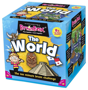
£11.95
Bragg Creek & Sheep Valley in a series of detailed hiking maps of the Canadian Rockies, covering the most popular areas of the Banff, Jasper, Kootenay & Yoho National Parks, as well as Waterton Lakes NP further south & the adjoining Goat Haunt area of Montana. The maps are contoured (50m or 25m interval in most titles) & some titles also have relief shading. Extensive overprint highlights hiking trails, many with detailed descriptions provided on the reverse. Most titles also include mountain bike, equestrian & ski routes. Symbols indicate various facilities, including camping grounds, hostels, lodges, visitors ...
Archived Product
£6.99
This is a pack of colourfully illustrated cards bursting with puzzles that will put children & adult`s brainpower to the test. Each brain-teasing puzzle sorts out the brainiacs from the bozos by testing their observation, memory, arithmetic & logic skills. The cards are wipe clean & the pack

Includes::
a special pen, making the pack entirely self contained, easily portable & a great gift.

...
Archived Product
£7.99
Who`s the smarty pants in your family? Packed with number & logic puzzles, riddles, dingbats, codes & much more, this fun & challenging travel-themed activity book is perfect for car journeys, holidays & rainy days
- & provides a great test for both kids & adults. Designed for children aged 7+. Brain teasers include: Scrambled Cities
- anagrams of famous places Code breaker
- morse code messages to decipher Flagtastic
- match the country to its flag World traveller, desert & jungle word searches Say what you see
- solve the visual word puzzles Flag finder
- crack a series of semaphore messages Riddles of the Sphinx
- crafty cryptic questions Arctic explorer crossword & airport sudoku


...
Archived Product
£13.99
In which city would you cross the Bosphorus Bridge linking Europe & Asia? Ride a cable car to Table Mountain? Brain Box Cities is designed for you to play with your family & friends. It will help improve obsertation & memory skills as well as knowledge about some of the most iconic cities in the world. Each card shows images, foods, people & facts from cities all around the world. The object of the game is to study a card for 10 seconds & then answer a question based on the roll of a die. If the question is answered correctly, the card is kept & the person with the most number of cards after 5 or 10 minutes is the winner. Made from a minimum of 70% recycled material & designed in the UK. Box contains 71 cards, 1 rules card, 1 sand timer & 1 die. Suitable for ages 8+. ...
Archived Product
£13.99
Learning French has never been more useful, as languages now play an increased role in the National Curriculum. This Brain Box game will help improve Observation & Memory skills as well as introduce French vocabulary. Each of the cards shows a scene with words in both French & English. The Reverse of each card has two levels of questions, one for beginners, the other for the more confident. This Brian Box game is great fun & a valuable learning tool. ...
Archived Product
£11.50
Map No. 2611E, Braine, in IGN’s excellent, detailed topographic survey of France at 1:25, 000. The map covers the western section of the crossing of the Aisne at Vailly-sur-Aisne by the British Expeditionary Force on 13th September 1914 during the First Battle of the Aisne. Please note: Vénizel is just off this map on the adjoining sheet to the west 2611O – Soissons. Although not specifically designed to show WWI memorial sites & best used in conjunctions with one of the specialist maps on the Western Front, maps in the IGN 1:25, 000 series are ideal for locating access to the numerous smaller war cemeteries & memorials scattered across northern France. The map is contoured, GPS compatible & shows all the features expected of topographic mapping at this scale. Map legend is in French only. To see the full description of IGN’s 1:25, 000 topographic survey of France & the list of all the titles in this series please click on the series link. ...
Archived Product
£9.50
Topographical survey of Belgium at 1:20, 000 from Nationaal Geografisch Instituut / Institut Géographique National, the country’s national survey organization. Each 20K map covers one quarter of the corresponding 1:50, 000 map (with adjustments in the border & coastal areas). The maps provide all the information expected of topographic mapping at this scale & in addition have an unusually large amount of vegetation and/or land use information (different types of woodlands, gardens, orchards, heath, etc). The maps have a 1-km UTM grid, with margin ticks for latitude & longitude at intervals of 1`. Map legend & a glossary of terms used on the maps include English. Stanfords keeps as regular stock 20K maps for the World War I battlefields around the Ypres, Messines & Passchendaele, & for the area of the Battle of Waterloo. The 1:20, 000 survey covers the whole of Belgium & maps for other regions can be supplied as special orders. To see the list of titles in this series please click on the series link.PLEASE NOTE: the Long-Distance Footpaths Map of Belgium at 1:300, 000 which shows the division of Belgium into the 50K survey sheets can also be used to see in more detail coverage by the 20K maps. ...
Archived Product
£6.39
A detailed topographic map of Braintree & Saffron Walden from the Ordnance Survey Explorer series, covering Halstead & Great Dunmow. Edition A2; Publication date August 2011 About this series: These highly detailed maps show all the administrative boundaries, settlements as small as isolated farms, the road network down to unfenced roads & country tracks, & field boundaries (hedges & drystone walls) which make navigation across the countryside much easier. Steep gradients on roads are indicated. Various landmarks, e.g. powerlines, archaeological sites, windmills, churches & lighthouses are shown & additional graphics indicate natural terrain features such as cliffs, scree, mud & vegetation variations. The contour interval is 5 metres in the lower parts of the country & 10 metres in the uplands, & spot heights are marked. Each map covers an area of 30 x 20km (i.e. approx. 19 x 12 miles), with some double-sided maps covering more, as indicated in the individual descriptions. The maps are fully GPS compatible, with the National Grid shown at 1km intervals & latitude & longitude indicated by margin ticks at 1'. The Explorer series has replaced the earlier, green-cover Pathfinder maps. The Explorer series is now complete & covers all of Engl&, Wales & Scotl&. Some sheets for popular areas like the National Parks are still branded as Outdoor Leisure (OL) maps, but are now included in this series as the cartography is the same as that in the Explorer Maps. The Explorer maps offer a substantial improvement on the Pathfinder series, with greater use of colour, larger area per map, & stronger emphasis on information for ramblers & tourists. This series is ideal for walking & other outdoor pursuits & each map shows a large amount of information for ramblers & tourists. Public rights of way are shown (except in Scotland), together with other routes with public access: National Trails & Recreational Paths, permitted paths & bridleways, & selected cycle routes. Open access land created under the Countryside & Rights of Way Act 2000 is marked. Tourist information

Includes::
caravan & camp sites, Park & Ride locations, recreation/leisure/sport centres, museums, historic buildings, English Heritage & National Trust sites, rural pubs, etc. The map legend is in English only, except for the tourist information content which is also in French & German.

...
Archived Product
£14.99
Braintree, Saffron Walden, Halstead & Great Dunmow area on a detailed topographic & GPS compatible map No. 195, waterproof version, from the Ordnance Survey’s 1:25, 000 Explorer series.MOBILE DOWNLOADS: this title & all the other OS Explorer maps include a code for downloading after purchase the digital version onto your smartphone or tablet for viewing on the OS smartphone app.OS EXPLORER SERIES: to see the list of all the titles in the OS Explorer series, both paper & waterproof versions, please click on the series link. The Explorer series, Ordnance Survey’s most detailed maps recommended for anyone enjoying outdoor activities, provides topographic coverage of Great Britain at 1:25, 000 on GPS compatible maps with hiking trails, cycling routes & extensive tourist information. Each printed map is available either on paper or as a waterproof & tear-resistant OS Active Map, as indicated in its title. Britain’s National Parks & other areas of particular tourist interest are presented on often double-sided OL (Outdoor Leisure) maps, whilst most standard format Explorers cover an area of 30 x 20km (approx. 19 x 12 miles). All three versions (paper, waterproof & digital) are the same & provide plenty of recreational & tourist information, indicating the traditional public right of way paths (except in Scotland where different laws apply), including bridleways & byways. National Trails & other long-distance paths are marked, as well as permissive footpaths or bridleways & on-road or traffic-free cycle routes with, where appropriate, their National/ Regional Cycle Network numbers. Boundaries of access land are clearly marked. A wide range of symbols provides additional tourist information, highlighting camping & caravanning sites, information offices & visitors’ centres, parking & picnicking places, country pubs, sport & recreational facilities including cycle hire locations & mountain biking trails, historic buildings & museums, etc. Exceptionally clear presentation of the landscape is provided by contours at 5m or in the uplands at 10m intervals, with additional spot heights plus colouring and/or graphics for different types of woodlands, orchards, heath, marshl&, scree or boulders, & other topographic features. For GPS users the maps have British National Grid lines at 1km intervals, with latitude & longitude given by margin ticks at 1`. Clearly laid out map legend

Includes::
French & German translations for the tourist information symbols.

...
Archived Product
£8.99
Braintree, Saffron Walden, Halstead & Great Dunmow area on a detailed topographic & GPS compatible map No. 195, paper version, from the Ordnance Survey’s 1:25, 000 Explorer series.MOBILE DOWNLOADS: this title & all the other OS Explorer maps include a code for downloading after purchase the digital version onto your smartphone or tablet for viewing on the OS smartphone app.OS EXPLORER SERIES: to see the list of all the titles in the OS Explorer series, both paper & waterproof versions, please click on the series link. The Explorer series, Ordnance Survey’s most detailed maps recommended for anyone enjoying outdoor activities, provides topographic coverage of Great Britain at 1:25, 000 on GPS compatible maps with hiking trails, cycling routes & extensive tourist information. Each printed map is available either on paper or as a waterproof & tear-resistant OS Active Map, as indicated in its title. Britain’s National Parks & other areas of particular tourist interest are presented on often double-sided OL (Outdoor Leisure) maps, whilst most standard format Explorers cover an area of 30 x 20km (approx. 19 x 12 miles). All three versions (paper, waterproof & digital) are the same & provide plenty of recreational & tourist information, indicating the traditional public right of way paths (except in Scotland where different laws apply), including bridleways & byways. National Trails & other long-distance paths are marked, as well as permissive footpaths or bridleways & on-road or traffic-free cycle routes with, where appropriate, their National/ Regional Cycle Network numbers. Boundaries of access land are clearly marked. A wide range of symbols provides additional tourist information, highlighting camping & caravanning sites, information offices & visitors’ centres, parking & picnicking places, country pubs, sport & recreational facilities including cycle hire locations & mountain biking trails, historic buildings & museums, etc. Exceptionally clear presentation of the landscape is provided by contours at 5m or in the uplands at 10m intervals, with additional spot heights plus colouring and/or graphics for different types of woodlands, orchards, heath, marshl&, scree or boulders, & other topographic features. For GPS users the maps have British National Grid lines at 1km intervals, with latitude & longitude given by margin ticks at 1`. Clearly laid out map legend

Includes::
French & German translations for the tourist information symbols.

...
Archived Product

Brainbox The World

Do you know where Machu Pichu is? Or what bird New Zealanders are named after? BrainBox World contains 71 beautifully-illustrated cards showing the very best this world has to offer, and then some! The object of the game is to study a card for 10 seconds and then answer a question based on the roll of a die. If the question is answered correctly, the card is kept and the person with the most number of cards after 5 or 10 minutes is the winner. Made from a minimum of 70% recycled material and designed in the UK.Box contains 55 cards, 1 rules card, 1 sand timer and 1 die. Suitable for ages 8+.
RIP - This product is no longer available on our network. It was last seen on 25.09.2019

This page now acts as a permanent archive for this product. Add more information using the comments box below to ensure it can still be found by future generations.

Use our search facility to see if it is available from an alternative contributor.
  • External links may include paid for promotion
  • Availability: Out Of Stock
  • Supplier: Stanfords
  • SKU: 5025822900012
Availability: In Stock
£13.99

Product Description

Do you know where Machu Pichu is? Or what bird New Zealanders are named after? Brain Box World contains 71 beautifully-illustrated cards showing the very best this world has to offer, & then some! The object of the game is to study a card for 10 seconds & then answer a question based on the roll of a die. If the question is answered correctly, the card is kept & the person with the most number of cards after 5 or 10 minutes is the winner. Made from a minimum of 70% recycled material & designed in the UK. Box contains 55 cards, 1 rules card, 1 sand timer & 1 die. Suitable for ages 8+.

Reviews/Comments

Add New

Intelligent Comparison

Oooops!
We couldn't find anything!
Perhaps this product's unique.... Or perhaps we are still looking for comparisons!
Click to bump this page and we'll hurry up.

Price History

Vouchers

No voucher codes found.
Do you know a voucher code for this product or supplier? Add it to Insights for others to use.

Facebook

Jargon Buster

Recycled - A term used to describe something which has been made from a reprocessed material
UK - United Kingdom - An island nation in Europe
World - A physical grouping, commonly used to describe earth and everything associated with ti

Supplier Information

Stanfords
Stanfords was established in 1853 and opened their iconic Covent Garden flagship store in 1901. They have become the top retailer of maps, travel books and accessories in the UK and arguably offer the largest selection of maps and travel books worldwide. Famous names such as Captain Robert Falcon Scott, Ranulph Fiennes and Michael Palin have purchased from Stanfords. They now have a shop in Bristol and both stores together with other venues operate a calendar of events including talks, book signings and exhibitions. As a specialist map retailer, the map selection is comprehensive and includes road maps, street maps and walking maps from worldwide destinations, as well as a selection of world atlases and wall maps. Books include travel guides and travel literature. Stanfords also stock globes, from miniatures made of blue marble to magnificent floor-standing globes. The website features a selection of interesting articles on travel topics.
Page Updated: 2023-11-12 20:15:36

Community Generated Product Tags

Oh No! The productWIKI community hasn't generated any tags for this product yet!
Menu