More From Contributor
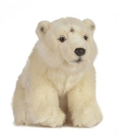
£5.99
Poland on four large indexed touring maps at 1:300, 000 from Michelin, each with city maps of the region’s main towns plus a distance table for the whole country. Road network, graded into seven types, indicates road width, gives driving distances on national & regional roads, & shows locations of fixed speed radars. Railway lines are shown with stations & local airports are marked. Topography is indicated by names of mountain ranges & peaks with heights, plus colouring for national parks or regional landscape parks & forested areas. Small symbols mark various places of interest, although the maps are designed primarily for driving rather than for planning sightseeing trips. The maps have latitude & longitude lines at intervals of 15’. The index is on the reverse, together with city maps of main towns. Map legend

Includes::
English.

...
Archived Product
£11.50
Poland on indexed, waterproof & tear-resistant touring maps from Reise-Know-How with historical names of main towns & other important locations which during the 19th & part of the 20th century were in Germany or in the Austro-Hungarian Empire. The maps are double-sided to provide the best balance between a good scale & a convenient size sheet. Road network is easy to see on a clear base which shows topography by altitude colouring with contours & spot heights, plus boundaries of national parks & other protected areas. Road network

Includes::
selected unsurfaced local roads & tracks, indicates locations of border crossings & shows driving distances on main & secondary roads. Railway lines are included & local airports are marked. Internal administrative boundaries are shown with names of the provinces. Symbols highlight various places of interest, including campsites, castles, churches, viewpoints, etc. The maps have latitude & longitude lines at intervals of 30’ & an index of place names. Map legend

Includes::
English.


...
Archived Product
£6.99
Recreational maps from Poland’s Army Cartographic Service. The maps use as their base the military topographic survey, with contours at intervals varying from 5m to 20m according to the terrain & contoured depths shown on lakes. An overprint highlights waymarked hiking, cycling & canoeing routes. A wide range of symbols indicate various sport & recreational facilities, places of interest, special natural features, etc. The maps have latitude & longitude grid at 1’ intervals. Map legend

Includes::
English. On the reverse there are useful addresses & description, in Polish only.

...
Archived Product
£6.99
Road map of Poland designed to highlight the country’s various tourist attractions, with 161 sights prominently highlighted & cross-referenced to their descriptions on the reverse side, plus enlargements showing popular tourist regions in greater detail. The main map covers Poland at 1:685, 000, with the 161 selected sights numbered & many also highlighted by small drawings. The selected sights include historic buildings, national parks, recreational areas, etc. Symbols indicate numerous other places of interest. Road network shows main roads with their numbers & driving distances; smaller regional & local roads have no numbers, but five of Poland’s most visited regions are presented in more detail on the accompanying enlargements: the island of Wolin, Hel Peninsula with the adjoining area south to Wejherowo, the Great Lakes of the Mazury district, plus Karkonosze & Tatra Mountains with their respective foothills. On the reverse the 161 recommendations are arranged by administrative regions & presented with brief descriptions. Attractions in major cities are shown on extracts from the publishers’ street plans. Also provided are lists of Poland’s UNESCO World Heritage sites, national parks & important buildings, all with brief descriptions. Map legend & all the text are in Polish only. ...
Archived Product
£19.99
Seeing is believing: Photicular technology is a phenomenon. Three years
- two titles, Safari & Ocean
- & 723, 000 copies in

...
Archived Product
£6.99
A sequel to ” Brown Bear, Brown Bear, What Do You See?”, Bill Martin`s playful story combining animals, colours & sounds, is beautifully illustrated by Eric Carle. A simple rhythmic text introduces the reader to a menagerie of wild animals from a roaring lion to a fluting flamingo & a trumpeting elephant. With refreshed colour artwork, this paperback reissue celebrates the 20th Anniversary of the second title in the series, ” Polar Bear, Polar Bear, What Do You Hear?”. ...
Archived Product
£10.99
Polar Bear has lost his underwear! Where could it be? There`s only one thing to do: Remove the book`s underwear-shaped bellyband to find the missing pair! Is that Polar Bear`s underwear? No, it`s Zebra`s—see the colourful stripes? What about that itty-bitty pair? No, those belong to Butterfly! & so the search continues, with every page revealing an animal in eye-popping undies. This laugh-out-loud, one-of-a-kind novelty book from Japanese design talents tupera tupera will surprise & amuse children & their parents, all while affirming the importance of putting on your underwear. ...
Archived Product
£20.00
The International Code for Ships Operating in Polar Waters has been developed to supplement existing IMO instruments in order to increase the safety of ships` operation & mitigate the impact on the people & environment in the remote, vulnerable & potentially harsh polar waters. The Code acknowledges that polar water operation may impose additional demands on ships, their systems & operation beyond the existing requirements of the International Convention for the Safety of Life at Sea (SOLAS), 1974, the International Convention for the Prevention of Pollution from Ships, 1973, as modified by the Protocol of 1978 relating thereto as amended by the 1997 Protocol (MARPOL), & other relevant binding IMO instruments. The Code acknowledges that the polar waters impose additional navigational demands beyond those normally encountered. In many areas, the chart coverage may not currently be adequate for coastal navigation. It is recognized even existing charts may be subject to unsurveyed & uncharted shoals. The Code also acknowledges that coastal communities in the Arctic could be, & that polar ecosystems are, vulnerable to human activities, such as ship operation. The relationship between the additional safety measures & the protection of the environment is acknowledged as any safety measure taken to reduce the probability of an accident, will largely benefit the environment. While Arctic & Antarctic waters have similarities, there are also significant differences. Hence, although the Code is intended to apply as a whole to both Arctic & Antarctic, the legal & geographical differences between the two areas have been taken into account. The key principles for developing the Polar Code have been to use a risk-based approach in determining scope & to adopt a holistic approach in reducing identified risks. It will come into effect only in 2017 for new ships & 2018 forexisting ships. ...
Archived Product
£9.99
Wordie's career as both an explorer & academic geologist opened up his participation in Shackleton's epic Endurance expedition of 1914-1916, where he proved one of the most resilient of those stranded in appalling conditions on Elephant Isl&. He continued to lead arduous expeditions well into his forties, while building his reputation as an academic & mentor. During the Second World War, he was instrumental in safeguarding British strategic interests in the Antarctic territories, & later rose to be President of the Royal Geographical Society & Master of St John's College, Cambridge. He died in 1962. Michael Smith captures all the drama of an extraordinary life lived at the edge & goes a long way to establishing James Wordie in his rightful place in the pantheon of great British explorers. ...
Archived Product
£18.00
In December of 2013, Alex Hibbert led an international quartet of polar travellers to the extreme north of Arctic Greenl&. After a huge storm destroyed their intended route to the North Pole in the darkness of winter, instead of retreating, they decided to explore the beautiful but unforgiving region of Avanerriaq, the home of the Polar Eskimos. What followed was six months of harsh education, gripping adventure &... twenty unruly sled dogs. ...
Archived Product

Polar Bear Small

The polar bear is a large bear which lives in the Arctic. They are strong and fast, and can run as fast as 25 mph for a short distance! Learn more about this magnificent animal with Living Nature! Each soft toy comes with a hang tag full of interesting facts about that animal.
RIP - This product is no longer available on our network. It was last seen on 25.09.2019

This page now acts as a permanent archive for this product. Add more information using the comments box below to ensure it can still be found by future generations.

Use our search facility to see if it is available from an alternative contributor.
  • External links may include paid for promotion
  • Availability: Out Of Stock
  • Supplier: Stanfords
  • SKU: 5037832307798
Availability: In Stock
£23.99

Product Description

The polar bear is a large bear which lives in the Arctic. They are strong & fast, & can run as fast as 25 mph for a short distance! Learn more about this magnificent animal with Living Nature! Each soft toy comes with a hang tag full of interesting facts about that animal.

Reviews/Comments

Add New

Intelligent Comparison

Oooops!
We couldn't find anything!
Perhaps this product's unique.... Or perhaps we are still looking for comparisons!
Click to bump this page and we'll hurry up.

Price History

Vouchers

No voucher codes found.
Do you know a voucher code for this product or supplier? Add it to Insights for others to use.

Facebook

Jargon Buster

Toy - A generic term for something that can be played with for enjoyment
soft - A descriptive word for an item/sound which is gentle to the touch or ears
strong - A descriptive word for an item that has physical strength
Large - something that takes up more space than normal.
Small - something that takes up less space than normal.

Supplier Information

Stanfords
Stanfords was established in 1853 and opened their iconic Covent Garden flagship store in 1901. They have become the top retailer of maps, travel books and accessories in the UK and arguably offer the largest selection of maps and travel books worldwide. Famous names such as Captain Robert Falcon Scott, Ranulph Fiennes and Michael Palin have purchased from Stanfords. They now have a shop in Bristol and both stores together with other venues operate a calendar of events including talks, book signings and exhibitions. As a specialist map retailer, the map selection is comprehensive and includes road maps, street maps and walking maps from worldwide destinations, as well as a selection of world atlases and wall maps. Books include travel guides and travel literature. Stanfords also stock globes, from miniatures made of blue marble to magnificent floor-standing globes. The website features a selection of interesting articles on travel topics.
Page Updated: 2023-11-12 20:15:36

Community Generated Product Tags

Oh No! The productWIKI community hasn't generated any tags for this product yet!
Menu