More From Contributor
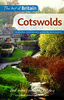
£2.95
The Glos RA handbook to accommodation along the Cotswold way, this booklet produced by the Gloucestershire Area R. A. has sold very well over the years & it complements the various Cotswold Way books & maps on Cotswold way. This is a must have for anyone walking the the Famous Cotswold way. The booklet shows the Cotswold Way & lists everything the walker of the way would need: the route, progressive mileage, suggested walking schedules, accommodation & food list, guest houses, camping facilities, travel & general information, places of interest along the Way, & more. ...
Archived Product
£13.95
The Cotswold Way, a 164km / 102 mile National Trail from Chipping Campden in the north to Bath in the south, presented at 1:40, 000 on a light, waterproof & tear-resistant map from Harvey Map Services. The route is shown on nine panels, with additional small street plans of Chipping Campden & Bath. Maps in the Harvey’s series covering Great Britain’s national trails & other long-distance footpaths are printed on light, waterproof & tear-resistant synthetic paper & cover the routes at 1:40, 000 or 1:60, 000. Topography is shown by contours at 15m intervals, with additional spot heights plus colouring and/or graphics to provide a very detailed picture of the terrain (boulder fields, scree, crags, etc) & vegetation / land use (pastures, moorl&, woodlands, etc). In Scotland peaks & hills classified as Munros, Corbetts & Donalds are marked. The overprint for the long-distance trail shows sections on local or main roads (highlighting danger points), on tracks, & on footpaths, indicating intermittent or not visible paths. The maps also show other right of way paths, including permissive paths & bridleways. Symbols indicate various facilities & accommodation options (including campsites & youth hostels), pubs & refreshments, food shops, banks, information points, etc, both along the route itself & in the nearby locations. All maps are GPS compatible, with the British National Grid overprinted on each panel. The maps also include useful contact details & general advice. To see other titles in this series please click on the series link. ...
Archived Product
£11.99
All-in-one hiking route guide & maps to the Cotswold Way, a 102-mile National Trail that runs from Chipping Campden to Bath, following the beautiful Cotswold escarpment for most of its course. The trail leads through quintessentially English countryside with little villages of honey-coloured stone to the well-known town of Bath.

Includes::
44 large-scale maps (3 1/8 inches to 1 mile); 9 town plans & 8 overview maps. Full details of all accommodations & campsites, restaurants & pubs; plus full public transport information. Plus day-walks. Fully revised & rewalked 3rd edition.* 44 large-scale walking maps
- at just under 1:20, 000
- showing route times, places to stay, points of interest & much more * 9 town plans
- Chipping Campden, Broadway, Winchcombe, Cheltenham, Painswick, Dursley, Wotton-under-Edge, & the city of Bath * 8 area maps & trail profiles * Itineraries for all walkers
- whether walking the route in its entirety over seven to eight days or sampling the highlights on day walks & short breaks * Practical information for all budgets
- camping, bunkhouses, hostels, B& Bs, pubs & hotels; Chipping Campden to Bath
- where to stay, where to eat, what to see, plus detailed street plans * Comprehensive public transport information
- for all access points on the Cotswold Way. * Flora & fauna
- four page full color flower guide, plus an illustrated section on local wildlife * Green hiking
- understanding the local environment & minimizing our impact on it * Bath city guide *

Includes::
downloadable gps waypoints


...
Archived Product
£14.99
The Cotswold Way crosses some of the most densely populated & varied landscapes from the each period of the past. The route also has some nationally important archaeological sites along, behind & in front of it. This book introduces the serious trail walker or the local `single-stretch` day rambler to the types of archaeological monuments along the Cotswold Way route. It then follows each of the six sections of the route describing the individual sites & their background along the trail. For those who wish to explore the Cotswold plateau behind the route there will be recommended archaeological walks, & for each type of walker the `archaeological` panoramas in front of the Cotswold Escarpment are identified & explained. ...
Archived Product
£14.99
Following the limestone escarpment on the Western edge of the Cotswolds, the 102 miles of the Cotswold Way take the walker through a quintessentially English landscape as varied as it is beautiful. Starting & finishing among the golden Cotswold stone of Chipping Camden & Bath, & affording stunning prospects of the Malvern Hills, the Forest of Dean & even the Black Mountains in Wales, it winds through rolling farml&, magnificent beech woodlands, & up over the austerely beautiful Cleeve Hill with its panoramic views out over Cheltenham & far beyond. With a wealth of historic interest, from Neolithic burial mounds to Roman villas & country houses, this is genuinely a walk through the heart of Engl&. ...
Archived Product
£12.99
Cotswolds in Crimson’s ‘ Best of Britain’ series, encompassing a range of guides covering Britain’s regions, exploring some of the best places to eat, find organic & local produce, as well as things to do in wet weather, places to stay & local legends, festivals & pubs. The guides are particularly child-friendly, with a range of activities for those visiting with children. Extensive introductory sections cover factual information about the region, with details of when to go, getting there & around, accommodation, food & drink, festivals & annual events, travelling with children, activities, organised holidays & courses & further practical tourist guidance. A background section also offers insights into the area’s history, geography & geology, wildlife & habitats, culture & local heroes. The main guide section of each title is organised geographically by region, with a list of ‘unmissable highlights’ in the region opening each chapter, so readers can see the main highlights at a glance. ‘ What to see & do’ sections are arranged under ‘fair weather’ & ‘wet weather’, to allow visitors the flexibility to plan their trip accordingly. Each guide in the series incorporates a number of themed maps such as recommended restaurants & gastro-pubs, things to do with children & historical experiences. ‘ Photo Essays’ – a series of colour photographs documenting the region’s highlights – are also included, exploring the local landscape, countryside & where appropriate, coastline. ...
Archived Product
£5.95
Cotswolds & Chilterns Visitors’ Map from Geographers’ A-Z Map Company, covering at 1:158, 400 (1” to 2.5 miles) a wide area across the Home Counties, with an index listing both town/villages & places of interest highlighted on the map. Coverage along the map southern edge extends from the Heathrow Airport & the junction of M25 & M3 motorways to Bath & Bristol. Across its centre the map stretches from Luton to Gloucester & Hereford. Coverage northwards extends to Worcester, Stratford-upon-Avon, Royal Leamington Spa & Northampton. Areas of Outstanding Natural Beauty are highlighted by colouring. Road network is shown with Primary Route Destinations prominently marked, services on motorways & major roads, locations of safety cameras with speed limits, etc. A wide range of symbols indicates various attractions, places of interest & facilities, which are also listed in the index of towns & villages, placed next to the map. Current 18th edition of this title was published in 2014. PLEASE NOTE that unlike most titles in the A-Z Visitor’ series this title does not include street plans. To see the list of titles on A-Z’s Visitor’ series please click on the series link. ...
Archived Product
£9.99
Cotswolds & Shakespeare Country in the Landmark Visitor Guides series, exploring a range of places in Britain, Europe & the Caribbean, with a particular expertise in UK destinations. Each guide presents the reader with detailed, wide-ranging & accessible overview of the region or area, with a particular focus on history & culture, notable local attractions, the landscape, local events & family activities. A series of recommended walks & guided car tours exploring the region are also included in each title. The guides are arranged geographically by region & are ideal both for short & longer breaks, with practical guidance on recommended routes & tourist attractions, in addition to insightful inset boxes into local history, culture & traditions. Information on accommodation, restaurants & day-to-day information are more limited, though a compact Directory at the end of each guide provides basic listings of recommended accommodation & restaurants, as well as tourist information contacts & regional event calendars. International destinations also carry climate & country facts, basic phrases & other general travel practical guidance for travelling to the region. The British titles in the Landmark Visitor Guides series are highly recommended, covering titles that are rarely available from other publishers. ...
Archived Product
£14.99
The ` Four Shires` of the Cotswolds make up an Area of Outstanding Natural Beauty & this rural region is also packed with cultural treasures: castles & country houses, gardens & estates, Roman ruins & the historic Fosse Way. Author Caroline Mills shares her love of the Cotswolds with an enthusiastic, personal narrative guiding visitors from market towns to elegant abbeys, cheese-rolling competitions to Rollright Stones. This is a colourful guidebook that offers far more than dry practicalities; Mills interviews local craftsmen & characters, & reveals local stories & folklore. She shows the rewards to be had from `slow` breaks that allow you to get under the skin of the region, & highlights restaurants & cafes that use locally produced ingredients. Enjoy a performance by the Royal Shakespeare Company, find out more about the Cotswold Lion or discover the source of the River Thames. ...
Archived Product
£12.99
In this new, thoroughly updated edition of Bradt`s The Cotswolds (Slow Travel series), resident expert author Caroline Mills shares more of her favourite places in a region that remains as popular as ever. The area covered
Includes:: the Cotswold AONB, the Cotswold escarpment, hills & valleys, the Wiltshire Cotswolds & the area known as the Four Shires, along with the lesser-known `hidden` fringes of the Cotswolds. Also included are the three Cotswold `gateways`: Stratford-upon-Avon, Bath & Oxford. Caroline Mills has lived & worked in the region for over 40 years & writes in an entertaining & engaging first-person narrative combined with authoritative information. Organised in such a way to encourage you to slow down & make it easier to discover smaller areas in greater depth, the guide

Includes::
features such as interviews with locals who bring character to the region, activities to try with children, personally selected places to eat, drink & stay, coverage of the Arts & Crafts movement, & plenty of options for car-free travel: walking, cycling, river boats & local buses & trains. Cotswold Farm Park, home of Countryfile presenter Adam Henson, is also included. Featured within the guide are quirky events such as the Cheese-Rolling competition & Tetbury`s Woolsack Races; numerous & distinguished breweries & micro-breweries, including the famous Hook Norton Brewery, Bath Ales, Uley Brewery & Stroud Brewery; Oxford University, the world`s oldest, & the source of England`s longest river, the Thames. The Cotswolds` rich & diverse man-made heritage

Includes::
many famous castles & country houses: Blenheim Palace, Sudeley Castle, Chavenage & Kelmscott; well-known abbeys such as Prinknash, Hailes; & gardens & estates including Painswick Rococo Garden, Westonbirt Arboretum & Highgrove. Roman history is covered, too, notably in Bath & Cirencester, together with the Fosse Way, one of the most important Roman roads in the country. The Cotswolds continues to endear itself to anyone who visits
- its harmonious combination of quintessentially English villages, charming provincial market towns, interesting & appealing countryside & a wealth of local food-&-drink producers makes it an all-year-round destination, whether for a day trip, a quiet weekend away or a multi-week holiday. The region offers an incredible array of accommodation from unique country-house hotels to delightful farmhouse B& Bs on working farms, luxurious self-catering cottages to glamping & camping in secluded countryside. Visitors that have a particular passion or interest for gardens, the Arts & Crafts Movement, historic buildings, walking, horseriding or rural pursuits are well provided for within the Cotswolds.


...
Archived Product

Cotswolds

Pathfinder(R) Cotswolds covering parts of the Snowshill, Buckholt Wood and Burford. This selection offers interest, regional variety and balance of routes in the Cotswolds providing the best walks in the area. From an easy stroll through Castle Combe to the much more challenging walks on Bredon Hill this volume contains something for everyone. Covering walks through the whole of the Cotswolds both popular and little know scenic routes including Stanway, Bourton-on-the-Water and Blenheim Park. -See walk locations by Looking Inside Inside: -28 great Cotswold walks from 2 to 10 miles -Clear, large scale Ordnance Survey route maps -GPS reference for all Cotswold waypoints -Where to park, good pubs and places of interest en route -All routes have been fully researched and written by expert
outdoor writers -Beautiful photography of scenes from the walks Pathfinder(R) Guides are Britain`s best loved walking guides. Made with durable covers, they are the perfect companion for countryside walks throughout Britain. Each title features circular walks with easy-to-follow route descriptions, large-scale Ordnance Survey route maps and GPS waypoints.With over 70 titles in the series, they offer essential information for walkers throughout the country.
RIP - This product is no longer available on our network. It was last seen on 25.09.2019

This page now acts as a permanent archive for this product. Add more information using the comments box below to ensure it can still be found by future generations.

Use our search facility to see if it is available from an alternative contributor.
  • Availability: Out Of Stock
  • Supplier: Stanfords
  • SKU: 9780319090282
Availability: In Stock
£12.99

Product Description

Pathfinder (R) Cotswolds covering parts of the Snowshill, Buckholt Wood & Burford. This selection offers interest, regional variety & balance of routes in the Cotswolds providing the best walks in the area. From an easy stroll through Castle Combe to the much more challenging walks on Bredon Hill this volume contains something for everyone. Covering walks through the whole of the Cotswolds both popular & little know scenic routes including Stanway, Bourton-on-the-Water & Blenheim Park. -See walk locations by Looking Inside Inside: -28 great Cotswold walks from 2 to 10 miles -Clear, large scale Ordnance Survey route maps -GPS reference for all Cotswold waypoints -Where to park, good pubs & places of interest en route -All routes have been fully researched & written by expert outdoor writers -Beautiful photography of scenes from the walks Pathfinder (R) Guides are Britain`s best loved walking guides. Made with durable covers, they are the perfect companion for countryside walks throughout Britain. Each title features circular walks with easy-to-follow route descriptions, large-scale Ordnance Survey route maps & GPS waypoints. With over 70 titles in the series, they offer essential information for walkers throughout the country.

Reviews/Comments

Add New

Intelligent Comparison

Oooops!
We couldn't find anything!
Perhaps this product's unique.... Or perhaps we are still looking for comparisons!
Click to bump this page and we'll hurry up.

Price History

Vouchers

No voucher codes found.
Do you know a voucher code for this product or supplier? Add it to Insights for others to use.

Facebook

Jargon Buster

GPS - Global Positioning System - Global position using satellites
water - A chemical substance. Chemical formula H2O.
Wood - A hard material found in trees. Used for tool making, fuel and construction.
Large - something that takes up more space than normal.
Balance - Something that is evenly weighted to keep something upright.
Popular - Something that is admired and liked by many people.
Regional - An adjective to describe a set geographic area.
Reference - To prove evidence with a back up source.

Supplier Information

Stanfords
Stanfords was established in 1853 and opened their iconic Covent Garden flagship store in 1901. They have become the top retailer of maps, travel books and accessories in the UK and arguably offer the largest selection of maps and travel books worldwide. Famous names such as Captain Robert Falcon Scott, Ranulph Fiennes and Michael Palin have purchased from Stanfords. They now have a shop in Bristol and both stores together with other venues operate a calendar of events including talks, book signings and exhibitions. As a specialist map retailer, the map selection is comprehensive and includes road maps, street maps and walking maps from worldwide destinations, as well as a selection of world atlases and wall maps. Books include travel guides and travel literature. Stanfords also stock globes, from miniatures made of blue marble to magnificent floor-standing globes. The website features a selection of interesting articles on travel topics.
Page Updated: 2023-11-12 20:15:36

Community Generated Product Tags

Oh No! The productWIKI community hasn't generated any tags for this product yet!
Menu