
 United Kingdom
 France
 Germany
 Netherlands
 Sweden
 USA
USA
 Italy
Italy
 Spain
Spain
More From Contributor


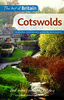
Cotswolds & Chilterns A-Z Visitors` Map
Cotswolds and Chilterns Visitors’ Map from Geographers’ A-Z Map Company, covering at 1:158, 400 (1” to 2.5 miles) a wide area across the Home Counties, with an index listing both town/villages and places of interest highlighted on the map. Coverage along the map southern edge extends from the Heathrow Airport and the junction of M25 and M3 motorways to Bath and Bristol. Across its centre the map stretches from Luton to Gloucester and Hereford. Coverage northwards extends to Worcester, Stratford-upon-Avon, Royal Leamington Spa and Northampton. Areas of Outstanding Natural Beauty are highlighted by colouring. Road network is shown with Primary Route Destinations prominently marked, services on motorways and major roads, locations of safety cameras with speed limits, etc. A wide
range of symbols indicates various attractions, places of interest and facilities, which are also listed in the index of towns and villages, placed next to the map. Current 18th edition of this title was published in 2014. PLEASE NOTE that unlike most titles in the A-Z Visitor’ series this title does not include street plans.To see the list of titles on A-Z’s Visitor’ series please click on the series link.
range of symbols indicates various attractions, places of interest and facilities, which are also listed in the index of towns and villages, placed next to the map. Current 18th edition of this title was published in 2014. PLEASE NOTE that unlike most titles in the A-Z Visitor’ series this title does not include street plans.To see the list of titles on A-Z’s Visitor’ series please click on the series link.
Product Description
Reviews/Comments
Add New
Vouchers
No voucher codes found.
Do you know a voucher code for this product or supplier? Add it to Insights for others to use.
Do you know a voucher code for this product or supplier? Add it to Insights for others to use.
 Denmark