
 United Kingdom
 France
 Germany
 Netherlands
 Sweden
 USA
USA
 Italy
Italy
 Spain
Spain
More From Contributor


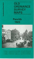
Penrith 1923
Penrith in 1923 in a fascinating series of reproductions of old Ordnance Survey plans in the Alan Godfrey Editions, ideal for anyone interested in the history of their neighbourhood or family. Selected towns in Great Britain and Ireland are covered by maps showing the extent of urban development in the last decades of the 19th and early 20th century.In this title: this detailed map covers most of the town of Penrith, stretching from the railway station northward to Fair Hill and the cemetery, and from Fell Lane westward to Castletown and the Poor Law Institution or Workhouse. Features include town centre with individual buildings neatly shown, railway with station, Market Square, Penrith Castle, Castle Park, Crown Square, auction mart, Sandgate, Brunswick Square, Christ Church,
Castletown area, allotment gardens, Poor Law Institution, Albert Iron Works, etc. On the reverse are extracts from a 1925 directory. About the Alan Godfrey Editions of the 25
Castletown area, allotment gardens, Poor Law Institution, Albert Iron Works, etc. On the reverse are extracts from a 1925 directory. About the Alan Godfrey Editions of the 25
Product Description
Reviews/Comments
Add New
Intelligent Comparison
Archived Product
Penrith 1923 Stanfords
£3.50
Archived Product

Penrith Stanfords
£2.50
Archived Product
Bedworth 1923 Stanfords
£3.50
Vouchers
No voucher codes found.
Do you know a voucher code for this product or supplier? Add it to Insights for others to use.
Do you know a voucher code for this product or supplier? Add it to Insights for others to use.
 Denmark