More From Contributor

£12.95
Walking in Pembrokeshire is experienced walkers Dennis & Jan Kelsall’s Cicerone guide some of the best circular walks in Wales’ far west. The routes included in the guide are varied
- some take you through the Preseli Hills & to the Daugkeddau’s hidden tidal reaches, as well deep wooded gorges, prehistoric hill-forts, medieval castles & isolated churches. There is a wide variety of routes that range between 2 & 12 miles meaning the book caters for a range of different walking experiences. The guide is structured into 40 walks that explore the varying landscapes of Pembrokeshire & offer different experiences for days out. Each walk has an Information Box providing details of the starting point, distance, time, height gain, the relevant OS map, parking facilities, public transport & refreshments en route. A detailed introduction gives practical guidance on the National Par 6, Pembrokeshire’s coast other practical consideration walkers should take into account. Detailed route descriptions are accompanied by Ordnance Survey extracts mapping the route in addition to colour photographs illustrating some of the highlights of the region.
...
Archived Product
£12.95
Guidebook to 40 circular walks in Pembrokeshire in Wales. The routes, which range from 1 to 12 miles, take in the dramatic beauty of the national park & its coast, the Daugleddau & the Preseli Hills, while exploring wooded gorges, prehistoric hillforts & medieval castles. Step-by-step route descriptions are accompanied by 1:50, 000 mapping. For each route, information is also given regarding parking & public transport options, as well as toilets & refreshments available along the way. The guide also

Includes::
a useful route summary table, plus information on tides, the terrain, & weather in the region. This collection of walks

Includes::
something for everyone, from novices to experienced ramblers. None of the walks demand technical skill &, in good weather, pose few navigational problems. Whether following the coast, wandering the hills or exploring the valleys & woods, the walking everywhere is superb & will invariably reveal something unexpected along the way.


...
Archived Product
£8.99
Discover both the breath-taking splendour of the Pembrokshire coast & its diverse inland landscape. The 25 comparatively short, easy walks in this book include clear route directions, map & a brief description of features encountered along the way as well as recommendations for refreshment. ...
Archived Product
£6.99
As the home of Britain`s one & only national coastal park, Pembrokeshire is rightly famed for its marine wildlife, unspoilt beaches, towering cliffs & charming harbours. Inl&, however, you will also find ancient woodlands & rolling hills, as well as archaeological mysteries & crumbling castles which suggest that this peaceful part of Wales has a far more turbulent past. The 40 moderate walks in this volume from award winning publisher Pocket Mountains, explore the stunning coastline as well as the heartland of the county, with several routes making use of sections of established long-distance walking trails. ...
Archived Product
£9.95
The acclaimed “ Battleground” series from the renowned military publishers Pen & Sword provides an extensive range of titles describing specific battles, particularly during the two World Wars. Well written & illustrated with contemporary photos, drawings & maps, the books give much more detailed & vivid descriptions than found in more general titles, bringing the battlefields alive for visitors as well as informing & entertaining readers at home. Where appropriate, the guides include recommendations for visiting the memorials, cemeteries, monuments & museums by local walks and/or car tours & include recommendations for further reading. ...
Archived Product
£17.99
Topographic survey of Portugal at 1:50, 000 from the Instituto Geográfico do Exército, the country’s military survey organisation. The maps have contours at 20m intervals & in addition to the standard features shown on topographic mapping at this scale also indicate various types of terrain or vegetation (s&, terraces, rocks, woodlands, vineyards, etc). Each sheet covers an area of 32 x 20km (20 x 12.5 miles approx). The maps have a 1-km UTM grid plus latitude & longitude coordinates for the map corners. Map legend & a glossary of terms used on the maps include English.EDITION DATES: most titles in this series date from 1990s or later. To see all the titles in this series please click on the series link. ...
Archived Product
£17.99
Topographic survey of Portugal at 1:50, 000 from the Instituto Geográfico Português, the country’s civilian survey organisation. The maps have contours at 25m intervals & in addition to the standard features shown on topographic mapping at this scale also indicate various types of vegetation (vineyards, olive groves, etc). Each sheet covers an area of 32 x 20km (20 x 12.5miles approx). The maps have latitude & longitude margin ticks at 1’ intervals & UTM coordinates for the map corners – each sheet also shows conversion details from BBLx (Bessel-Bonnie system, Datum Lisbon) to UTM. Map legend is in Portuguese only.EDITION DATES: most titles in this series have now been updated in the 1990s or later. To see all the titles in this series please click on the series link. ...
Archived Product
£17.99
Topographic survey of Portugal at 1:50, 000 from the Instituto Geográfico do Exército, the country’s military survey organisation. The maps have contours at 20m intervals & in addition to the standard features shown on topographic mapping at this scale also indicate various types of terrain or vegetation (s&, terraces, rocks, woodlands, vineyards, etc). Each sheet covers an area of 32 x 20km (20 x 12.5 miles approx). The maps have a 1-km UTM grid plus latitude & longitude coordinates for the map corners. Map legend & a glossary of terms used on the maps include English.EDITION DATES: most titles in this series date from 1990s or later. To see all the titles in this series please click on the series link. ...
Archived Product
£17.99
Topographic survey of Portugal at 1:50, 000 from the Instituto Geográfico Português, the country’s civilian survey organisation. The maps have contours at 25m intervals & in addition to the standard features shown on topographic mapping at this scale also indicate various types of vegetation (vineyards, olive groves, etc). Each sheet covers an area of 32 x 20km (20 x 12.5miles approx). The maps have latitude & longitude margin ticks at 1’ intervals & UTM coordinates for the map corners – each sheet also shows conversion details from BBLx (Bessel-Bonnie system, Datum Lisbon) to UTM. Map legend is in Portuguese only.EDITION DATES: most titles in this series have now been updated in the 1990s or later. To see all the titles in this series please click on the series link. ...
Archived Product
£7.99
Penang & Langkawi on a double-sided map from Periplus, with an overview map of Peninsular Malaysia & street plans of Georgetown & Kuah.

Includes::
many places of interest, restaurants & hotels. On one side of the map appears Penang Island & the neighbouring part of the mainland across the bridge, all at 1:50, 000. The network of main roads is shown & main places of interest highlighted, such as nature reserves, beaches & hotels. A base with bold relief shading shows the terrain, with spot heights given for the main peaks. Some trails are indicated for hiking in the interior. The reverse shows Langkawi at 1:125, 000, with some neighbouring islands. Main roads, relief shading, spot heights & places of interest also appear on this map. The map also
Includes:: An overview map of Peninsular Malaysia at 1:3, 000, 000, showing major roads, railway lines & places of interest. A large, indexed street plan of Georgetown at 1:15, 000. A street plan (not indexed) of Kuah at 1:20, 000. The street plans are annotated with places of interest & numerous restaurants, hotels, etc. The legend provides a list of toponyms in the Bahasa Malaysia language with translations. Latitude & longitude lines are drawn only on the map of Peninsular Malaysia at intervals of 2


...
Archived Product

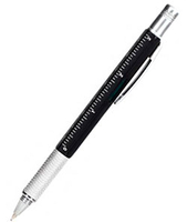
Pen 4-in-1 Multi Tool

The 4-in1 Pen Tool by Kikkerland is a pen which holds 4 essential tools. There is a double screwdriver head (one side slotted and the other Philips), hidden in the cap. Along the body of the pen you have a 3 inches and 7cm ruler, and a spirit level. Just twist the grooved part of the pen to reveal the black ink biro. The pen is mainly made of plastic but the clip and the screwdriver head are made of metal.This is a nice little gadget which will delight any DIY enthusiast!
RIP - This product is no longer available on our network. It was last seen on 25.09.2019

This page now acts as a permanent archive for this product. Add more information using the comments box below to ensure it can still be found by future generations.

Use our search facility to see if it is available from an alternative contributor.
  • External links may include paid for promotion
  • Availability: Out Of Stock
  • Supplier: Stanfords
  • SKU: 0612615000971
Availability: In Stock
£3.99

Product Description

The 4-in 1 Pen Tool by Kikkerland is a pen which holds 4 essential tools. There is a double screwdriver head (one side slotted & the other Philips), hidden in the cap. Along the body of the pen you have a 3 inches & 7cm ruler, & a spirit level. Just twist the grooved part of the pen to reveal the black ink biro. The pen is mainly made from plastic but the clip & the screwdriver head are made from metal. This is a nice little gadget which will delight any DIY enthusiast!

Reviews/Comments

Add New

Intelligent Comparison

Oooops!
We couldn't find anything!
Perhaps this product's unique.... Or perhaps we are still looking for comparisons!
Click to bump this page and we'll hurry up.

Price History

Vouchers

No voucher codes found.
Do you know a voucher code for this product or supplier? Add it to Insights for others to use.

Facebook

Jargon Buster

Black - A colour which does not emit any colour of the spectrum. Black absorbs all frequencies of the spectrum.
Ink - A liquid containing pigments and dyes
Plastic - A generic term for a synthetic product used in the manufacture of products
Philips - Manufacturers of consumer electronics and products
screwdriver - A tool for driving screws. May be rotated manually or by electric motor.
gadget - An electrical or technological item which has a specific function. Often considered a novelty but often cleverly designed
Spirit Level - A device used to indicate how level, horizontal or vertical, a surface is
DIY - Do It Yourself
Head - The upper part of a body typically separated by the neck.

Supplier Information

Stanfords
Stanfords was established in 1853 and opened their iconic Covent Garden flagship store in 1901. They have become the top retailer of maps, travel books and accessories in the UK and arguably offer the largest selection of maps and travel books worldwide. Famous names such as Captain Robert Falcon Scott, Ranulph Fiennes and Michael Palin have purchased from Stanfords. They now have a shop in Bristol and both stores together with other venues operate a calendar of events including talks, book signings and exhibitions. As a specialist map retailer, the map selection is comprehensive and includes road maps, street maps and walking maps from worldwide destinations, as well as a selection of world atlases and wall maps. Books include travel guides and travel literature. Stanfords also stock globes, from miniatures made of blue marble to magnificent floor-standing globes. The website features a selection of interesting articles on travel topics.
Page Updated: 2023-11-12 20:15:36

Community Generated Product Tags

Oh No! The productWIKI community hasn't generated any tags for this product yet!
Menu