
 United Kingdom
 France
 Germany
 Netherlands
 Sweden
 USA
USA
 Italy
Italy
 Spain
Spain
More From Contributor


Paris IGN Street Map
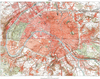
Paris at 1:12, 000 on a large street plan from the Institut Géorgaphique National, France’s national survey organization, with coverage extending west to include the whole of the Bois de Boulogne, La Défense and Boulogne-Billancourt. The arrondissements and the communes outside the Boulevard Périphérique are shown in different colours. Main traffic arteries are highlighted and the plan shows one way streets, car parks and locations of 24-hour petrol stations. Metro, RER and tram stops are marked, but not Velib’ pick up point or batobus stops. Streets are annotated with selected house numbers for easier identification of addresses. Main public buildings are named and symbols indicate museums, tourist information centre, police stations, etc. Street index is on the reverse
whist next to the map is a diagram of the metro/RER/tram network, a list of museums within the area covered by it, plus an aerial photo of the Louvre – Arc de Triomphe axis. Map legend includes English.A disappointing map - neither as clear and informative as the main Paris plan from Michelin, nor particularly suitable for exploring the city as a tourist. As the British Ordnance Survey has already discovered some years ago, making good street plans is a completely different skill from producing high quality topographic survey mapping!PLEASE NOTE: to see the list of IGN street plans of French towns and cities please click on the series link – the series description also includes a comparison between IGN and Blay-Foldex street plans.
whist next to the map is a diagram of the metro/RER/tram network, a list of museums within the area covered by it, plus an aerial photo of the Louvre – Arc de Triomphe axis. Map legend includes English.A disappointing map - neither as clear and informative as the main Paris plan from Michelin, nor particularly suitable for exploring the city as a tourist. As the British Ordnance Survey has already discovered some years ago, making good street plans is a completely different skill from producing high quality topographic survey mapping!PLEASE NOTE: to see the list of IGN street plans of French towns and cities please click on the series link – the series description also includes a comparison between IGN and Blay-Foldex street plans.

Product Description
Reviews/Comments
Add New
Vouchers
No voucher codes found.
Do you know a voucher code for this product or supplier? Add it to Insights for others to use.
Do you know a voucher code for this product or supplier? Add it to Insights for others to use.
 Denmark