
 United Kingdom
 France
 Germany
 Netherlands
 Sweden
 USA
USA
 Italy
Italy
 Spain
Spain
More From Contributor


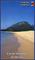
Orosei
Sardinia’s eastern coast around the town of Orosei on a detailed, contoured, GPS compatible map at 1:35, 000 from Abies Edizioni, with on the reverse notes on the area’s history, heritage and beaches. Contours are at 20m intervals with colouring for different types of vegetation. The map shows local footpaths and hiking trails, as well as recommended mountain bike routes. Symbols highlight various places of interest including campsites, beaches, diving and surfing sites, viewpoints, climbing sites, nuraghi, churches, etc. The map has a 1-km UTM grid. On the reverse are multilingual notes about the area and its heritage. Map legend and the notes include English.

Product Description
Reviews/Comments
Add New
Vouchers
No voucher codes found.
Do you know a voucher code for this product or supplier? Add it to Insights for others to use.
Do you know a voucher code for this product or supplier? Add it to Insights for others to use.
 Denmark