
 United Kingdom
 France
 Germany
 Netherlands
 Sweden
 USA
USA
 Italy
Italy
 Spain
Spain
More From Contributor


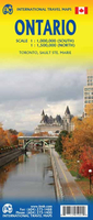
Ontario
Double-sided map of Ontario, part of a series of maps of Canadian provinces from the Vancouver-based ITMB, with topography presented by altitude colouring rather than by relief shading. The map divides the province east-west, showing on one side the eastern part from Ottawa to Lake Huron and 1:1, 000, 000, and on the reverse western Ontario at 1:1, 550, 000, with the area around Sault Ste. Marie shown as an inset.Topography is indicated by altitude colouring, with spot heights plus graphics for marshlands. Plenty of rivers and lakes are shown, with the larger ones also named. Numerous national parks or provincial protected areas are highlighted and Indian reservations are marked.The map shows the province
Product Description
Reviews/Comments
Add New
Intelligent Comparison
Archived Product
Ontario ITMB Stanfords
£9.99
Archived Product

Intrigo Stanfords
£9.99
Vouchers
No voucher codes found.
Do you know a voucher code for this product or supplier? Add it to Insights for others to use.
Do you know a voucher code for this product or supplier? Add it to Insights for others to use.
 Denmark