
 United Kingdom
 France
 Germany
 Netherlands
 Sweden
 USA
USA
 Italy
Italy
 Spain
Spain
More From Contributor

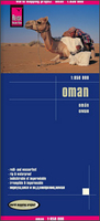
Oman Reise Know-How
Indexed, waterproof and tear-resistant road map of Oman at 1:850, 000 with topographic and tourist information, published by Reise Know-How as part of their highly acclaimed World Mapping Project. The map is double-sided to present the area at best possible scale on a convenient size sheet. Coverage on the northern side of the map includes Dubai, Sharjah and Al-Ain. Names of larger towns and settlements are also shown in Arabic; all other names are in the Latin alphabet only.Road network is easy to see on a clear base which shows the country’s topography by altitude colouring with contours, spot heights, and names of hill ranges and seasonal rivers. Internal administrative boundaries are shown with names of the provinces. Road network includes unsurfaced roads and 4WD tracks,
indicating locations of border crossings. A range of symbols highlights various places of interest, including UNESCO heritage sites, archaeological remains, selected hotels and youth hostels, oasis, bird sanctuaries and turtle breeding grounds, surfing and diving sites, etc. The map also indicates locations of oil fields and oil wells. The map has a latitude and longitude grid at intervals of 1° and an index of place names. Map legend includes English.
indicating locations of border crossings. A range of symbols highlights various places of interest, including UNESCO heritage sites, archaeological remains, selected hotels and youth hostels, oasis, bird sanctuaries and turtle breeding grounds, surfing and diving sites, etc. The map also indicates locations of oil fields and oil wells. The map has a latitude and longitude grid at intervals of 1° and an index of place names. Map legend includes English.

Product Description
Reviews/Comments
Add New
Vouchers
No voucher codes found.
Do you know a voucher code for this product or supplier? Add it to Insights for others to use.
Do you know a voucher code for this product or supplier? Add it to Insights for others to use.
 Denmark