More From Contributor
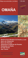
£9.99
Map No. 216, Olympic National Park, WA, in an extensive series of GPS compatible, contoured hiking maps of USA’s national & state parks or forests & other popular recreational areas. Cartography based on the national topographic survey, with additional tourist information. The maps, with most titles now printed on light, waterproof & tear-resistant plastic paper, highlight walking trails along with campsites & other accommodation, picnic sites, areas for various recreational pursuits such as horse riding or skiing, drinking water sources, & many other facilities of interest to the outdoor enthusiast. Cartography is based on information from the USGS (United States Geological Survey
- the country’s national survey organization), revised by the National Geographic Maps in cooperation with the National Park Service, USDA Forest Service, etc. Topography is excellently presented by contours (interval varies according to scale), enhanced by relief shading & colouring/graphics for wood cover, glaciers, etc. All heights are given in feet. The maps have a UTM grid plus latitude & longitude margin ticks & GPS waypoints for selected important locations. Each map is double-sided to give either maximum coverage of the chosen area or additional enlargements of its important sections. Accompanying notes provide useful information on relevant regulations, safety precautions, contact addresses, etc.* *IMPORTANT
- PLEASE NOTE: the series is very extensive, ranging in scale from 1:400, 000 for the vast national parks of Alaska to 1:25, 000 for local map in several states. We recommend, therefore, viewing the series by state rather than the whole list.*

...
Archived Product
£8.50
Olympic Peninsula & Washington Coast Road & Recreation Map from the Great Pacific Recreation & Travel Maps with nice, clear cartography, town maps & very extensive tourist information about recreational facilities, etc. The main map at 1:253, 000 approx. covers the Olympic Peninsula, extending south to the Grays Harbour bay & east just beyond the Hood Canal. Altitude colouring with names of peaks & other geographical features shows the topography. Numerous national/state parks or forests & other protected areas are marked. Road network is very clearly laid out, showing, where appropriate, names of local roads. Campsites & RV parks are marked, as well many other recreational facilities & places of interest including wildlife watching sites, breweries & wineries, etc. The map has a grid with latitude & longitude at 30’ intervals. On the reverse a map at 1:800, 000 shows the rest of Washington’s coastline, extending east to the No. 5 interstate highway. Enlargements, annotated with more accommodation & other facilities show: Long Beach
- Seaview
- Ilwaco, Aberdeen
- Hoquiam
- Cosmopolis, Port Townsend, Port Angeles, Sequiim, Shelton, Westport & central Victoria on the Vancouver Isl&. Numerous information panels provide extensive lists of additional tourist information for the Olympic Peninsula: campgrounds, parks & recreation areas; communities; plus boating, hiking trails, golf courses, entertainment & wildlife watching. Where appropriate, phone numbers & website addresses are included.


...
Archived Product
£5.99
Olympic Peninsula Camping & Hiking in the Moon Spotlight guide series; covering a range of specific local cities, districts, areas & regions in North, Central & South America & targeted at those seeking to travel to a specific area within a country. Each of the guides has been extracted in full from the relevant country * Moon Handbook* & individual titles focus on a particular city, region or notable area of the destination. Many of the guides in the series are unique in their coverage, although are limited in putting the destination into its wider geographical context that a more comprehensive guide would provide. Stylistically, Moon’s editorial style is strongly American in focus, often offering insights & observations with an American audience in mind. However, each Moon Spotlight guide is comprehensive in the information it provides & gives visitors the flexibility to opt for a more compact guide if they know in advance where they will be staying or travelling. ...
Archived Product
£7.99
Get a head start on the most important athletic event in the world with The Olympics, A Very Peculiar History! From its beginnings in Ancient Greek antiquity, right up to its arrival in Great Britain, the home of so many modern sports & favoured pastimes, the Olympic Games have always been a grand & exciting spectacle. Sometimes it's hard to believe that the first recorded Olympic running race was held nearly 3, 000 years ago. Even so, precious little has changed since. The athletes may now be fully-clothed, but that doesn't stop their speed & skills improving. New Olympic world records are beaten all the time. The Olympics, A Very Peculiar History gives an overview of the strange, the unbelievable & the downright bizarre events that have occurred over the many years this esteemed competition has seen. The book features amazing athlete statistics, biographies & records, & well as quirky stories, fascinating facts from the world of the Olympics. ...
Archived Product
£13.99
” Olympus is the highest Greek mountain; it is the mountain of Greek myths, the symbol of a civilization; it is a monument of nature.” This guide

Includes::
the following:- All the typical climbing routes to the top.- Hiking routes at lower slopes, which cover the entire mountain.- Detailed description for a total of 300km of trails with altitude sections & marking of the main points.- Practical tips for getting there & accommodation The maps are based on the “ Olympus 1: 25000” map by Anavasi publications.

...
Archived Product
£3.50
Omagh in 1906 in a fascinating series of reproductions of old Ordnance Survey plans in the Alan Godfrey Editions, ideal for anyone interested in the history of their neighbourhood or family. Coverage extends eastward to Tyrone County Hospital. Features include High Street, Market Street, John Street, Church Street, Campsie Road. Court House, Fair Green, Corn Market, RC church, Presbyterian church, Infantry Barracks, County Hospital, Creevenagh House, Campsie Saw Mills, Lisnamallard Mills, Lisnamallard House, Riverdale, Old Barracks, railway with station, goods shed, engine house, Market Goods station & branch, Meetinghousehill area, Dergmoney Lower area, Gortmore House, Coolnagard Lower area, etc. On the reverse are extracts from a street directory, including Abbey Street, Campsie Avenue, Campsie Road, Castle Street, Church Street, Dublin Road, George`s Street, High Street, John Street, Market Street & Mountjoy Road. About the Alan Godfrey Editions of the 25” OS Series: Selected towns in Great Britain & Ireland are covered by maps showing the extent of urban development in the last decades of the 19th & early 20th century. The plans have been taken from the Ordnance Survey mapping & reprinted at about 15 inches to one mile (1:4, 340). On the reverse most maps have historical notes & many also include extracts from contemporary directories. Most maps cover about one mile (1.6kms) north/south, one & a half miles (2.4kms) across; adjoining sheets can be combined to provide wider coverage.FOR MORE INFORMATION & A COMPLETE LIST OF ALL AVAILABLE TITLES PLEASE CLICK ON THE SERIES LINK. ...
Archived Product
£9.99
Of the five beaches attacked on 6 June, Omaha saw the sternest fighting. Well-placed defenders on the high ground & extensive beach defenses did their job. On top of this, so much had gone wrong with the first wave: many of the amphibious DD Sherman tanks didn`t reach the beach. They were released from their landing craft too far away where the greater swell swamped them & the troops landing on Omaha missed their firepower. Another problem was that many units landed in the wrong place. Strong tides & winds carried the landing craft off line & led to confusion. Finally, the German emplacements & defenses were well-placed on high ground & the only cover on the beach
- the seawal
- was over a killing ground. There were 32 fortified areas located between the Vire River & Port-en-Bessin: in all, 12 of these strongpoints were able to direct fire on Omaha Beach. The attacking forces-units of the US 29th & 1st Inf Divs
- suffered over 2, 000 casualties, many of them drowned during the approach, but led by US Rangers, themselves misplaced (they were the follow-up troops to Rudder`s Rangers who had scaled the Pointe du Hoc) the American troops pushed forward & by nightfall, they had gained hold of the beach & its immediate hinterl&. Despite the casualties, 34, 000 troops had been landed by the end of the day.


...
Archived Product
£9.99
Omalo
- Pass Abano
- Mt. Diklosmta area of the Caucasus Mountains in Georgia at 1:50, 000 on a double-sided, contoured & GPS

...
Archived Product
£15.99
Omalo
- Pass Abano
- Mt. Diklosmta area of the Caucasus Mountains in Georgia at 1:50, 000 on a double-sided, contoured & GPS

...
Archived Product
£9.50
Indexed, waterproof & tear-resistant road map of Oman, including the eastern part of the United Arab Emirates, with topographic & tourist information, published by Reise Know-How as part of their highly acclaimed World Mapping Project. The map is double-sided to present the area at best possible scale on a convenient size sheet. Road network is easy to see on a clear base which shows the area ...
Archived Product

Omaña

The Calecha map of Omana is a topographic map of 1:50, 000 with hypsometric tinting and relief shading. Includes information on roads, forest tracks, roads and trails. Also included are fountains, waterfalls, forests of interest, centennial trees, lagoons and tourist information, such as accommodations and locations with interesting architecture.
RIP - This product is no longer available on our network. It was last seen on 25.09.2019

This page now acts as a permanent archive for this product. Add more information using the comments box below to ensure it can still be found by future generations.

Use our search facility to see if it is available from an alternative contributor.
  • External links may include paid for promotion
  • Availability: Out Of Stock
  • Supplier: Stanfords
  • SKU: 9788494095177
Availability: In Stock
£14.99

Product Description

The Calecha map of Omana is a topographic map of 1:50, 000 with hypsometric tinting & relief shading.

Includes::
information on roads, forest tracks, roads & trails. Also included are fountains, waterfalls, forests of interest, centennial trees, lagoons & tourist information, such as accommodations & locations with interesting architecture.

Reviews/Comments

Add New

Intelligent Comparison

Oooops!
We couldn't find anything!
Perhaps this product's unique.... Or perhaps we are still looking for comparisons!
Click to bump this page and we'll hurry up.

Price History

Vouchers

No voucher codes found.
Do you know a voucher code for this product or supplier? Add it to Insights for others to use.

Facebook

Jargon Buster

Forest - A area with a high density of trees

Supplier Information

Stanfords
Stanfords was established in 1853 and opened their iconic Covent Garden flagship store in 1901. They have become the top retailer of maps, travel books and accessories in the UK and arguably offer the largest selection of maps and travel books worldwide. Famous names such as Captain Robert Falcon Scott, Ranulph Fiennes and Michael Palin have purchased from Stanfords. They now have a shop in Bristol and both stores together with other venues operate a calendar of events including talks, book signings and exhibitions. As a specialist map retailer, the map selection is comprehensive and includes road maps, street maps and walking maps from worldwide destinations, as well as a selection of world atlases and wall maps. Books include travel guides and travel literature. Stanfords also stock globes, from miniatures made of blue marble to magnificent floor-standing globes. The website features a selection of interesting articles on travel topics.
Page Updated: 2023-11-12 20:15:36

Community Generated Product Tags

Oh No! The productWIKI community hasn't generated any tags for this product yet!
Menu