More From Contributor
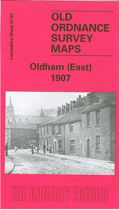
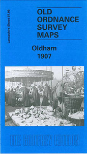
£5.50
ADAC, Germany's equivalent of the British Automobile Association publishes an extensive series of street plans which provide detailed high-quality mapping of all the major towns & cities, including their outer suburbs. The plans name all the individual streets & indicate all the main landmarks & public buildings. All public transport facilities are shown: buses, trams, underground & overland rail lines. One way streets & car parks are indicated. Plans of larger cities include an enlargement for the city centre. The plans also show the administrative & postal divisions & have an extensive street index which, where appropriate, shows individual postal codes for each street. On the reverse, each plan has a road map at 1:100, 000, covering a very wide area around the city. Map legend

Includes::
English.

...
Archived Product
£7.99
Falk, one of Germany`s leading publishers of street plans, produce their town plans in two different formats. Falk Extra plans are folded in a standard way, where the whole map can be opened to view the entire area it covers. For larger cities, the same mapping is also published with a special folding system designed to show only a small section of the map at one time. The whole map can be opened but it will be cut in several places. Many find these street plans very user-friendly & easier to handle than conventional maps. The plans, which cover towns with their outer suburbs, indicate main landmarks & public buildings & show all the public transport facilities, one way streets & car parks. Plans of lager cities include a separate map of the town centre at a more detailed scale & a diagram of the underground & the suburban rail network. The plans also show the postal divisions & have an extensive street index which, where appropriate, shows individual postal codes for each street. Map legend

Includes::
English. Falk Extra plans also include on the reverse a road map of the surrounding area.

...
Archived Product
£10.99
Oldenburger Land on a waterproof, tear-resistant, GPS compatible cycling map at 1:75, 000 from the ADFC (Allgemeiner Deutscher Fahrrad-Club
- the official German cycling federation), in a series of maps with extensive overprint for long-distance & local cycling routes. GPS waypoints, route profiles, details of online links for information about accommodation etc. are also provided. Maps included in this series are contoured & the interval varies according to the type of the terrain. Steep sections are annotated with gradient markings. Colouring and/or graphics show various types of landscape: woods, vineyards, etc. An overprint highlights both the national long-distance cycling routes & the shorter local cycling trails, each clearly identified by a symbol and/or an abbreviation of its name. Sections with heavy traffic and/or poor road surface are clearly marked. Symbols indicate various facilities, such as railway stations with cycle hire, cycle repair shops, campsites, youth hostels, shelters, country restaurants/bars, sport & leisure facilities. Maps have a UTM grid for measuring distances & for determining location using GPS device & they are printed on weather resistant & tear-resistant paper. Each map covers an area of Approx. 130 x 87 km & the map legend is in German only. To see all the titles in this series please click on the series link.
...
Archived Product
£8.99
A wickedly funny new series for ages six & up from the creator of Where Bear?, Pass It On & the Pom Pom series, with colour illustrations throughout. Jeanie`s Grandma is BAD. Not bad like a vampire or a gangster or anything, more like... up to no good. Sometimes she can be a bit embarrassing but most of the time she`s REALLY fun, especially when she gets Jeanie involved in her mischievous schemes. Everyone says she`s old enough to know better... but she doesn`t seem to care one bit. In fact, Jeanie thinks she might quite like it! Bad Nana is a deliciously wicked new series for ages six & up, told through the eyes of 8-year-old Jeanie. Gorgeously illustrated throughout with vibrantly coloured spreads, Bad Nana`s naughty exploits will shock & appal
- & make you snort with laughter!
...
Archived Product
£3.50
Oldham in 1907 in a fascinating series of reproductions of old Ordnance Survey plans in the Alan Godfrey Editions, ideal for anyone interested in the history of their neighbourhood or family. The map covers the heart of Oldham, with stretching from Westbourne Street eastward to Bleasby Street, & from Cromwell Street northward to Samson Street. Features include railway with Mumps station, St Mary`s church, Market Ground, Market Hall, Coldhurst Hollow, Bank Top, Cold Hurst, Sarah Moor, Oldham Edge, Moorhey, Townfield, Greenacres Moor, St James Mill, Soho Iron Works, Castle Iron Works, tramways, Hartford Old Works, Derker Old Mill, Albany Mills, Granville Mill, Greenbank Mills, Commercial Mills, tramway depot, Glodwick Road station, Hargreaves Spindle Works, Werneth Mill, Summervale Mill, Willowbank Mill, Royal Mill, many other mills, rope works, Oldham Boiler Works, etc. On the reverse are 1918 street directory entries for High Street, Market Place, Mumps, Rock Street, Union Street & Yorkshire Street. About the Alan Godfrey Editions of the 25” OS Series: Selected towns in Great Britain & Ireland are covered by maps showing the extent of urban development in the last decades of the 19th & early 20th century. The plans have been taken from the Ordnance Survey mapping & reprinted at about 15 inches to one mile (1:4, 340). On the reverse most maps have historical notes & many also include extracts from contemporary directories. Most maps cover about one mile (1.6kms) north/south, one & a half miles (2.4kms) across; adjoining sheets can be combined to provide wider coverage.FOR MORE INFORMATION & A COMPLETE LIST OF ALL AVAILABLE TITLES PLEASE CLICK ON THE SERIES LINK. ...
Archived Product
£3.50
Oldham South in 1906 in a fascinating series of reproductions of old Ordnance Survey plans in the Alan Godfrey Editions, ideal for anyone interested in the history of their neighbourhood or family. The map covers the southern side of Oldham, stretching from Windsor Road eastward to Abbey Hills Road, & from Wellington Street southward to Hollins Road & Hathershaw. Features include railway with Central & Clegg Street stations, Glodwick Brook, Glodwick, Alexandra Park, Brook Mills, Maple Mill, Earl Mill, Belgrave Mill, Castle Mill, Borough Mill, Pearl Mill, Glodwick Mill, Commercial Mill, Broadway Mills, Alma Mills, Copster Mill, Primrose Bank Mills, other mills, tramways, Chamber Colliery, Hulme Grammar School, Primrose Bank, Coppice, St Thomas`s church, Lowside Brick Works, Cherry Valley, Fitton Hill, etc. On the reverse are street directory entries for Ashton Road, Belgrave Road, Copster Hill Road, King Street, Lee Street, Park Road, Queen`s Road & Waterloo Street, plus an 1897 railway timetable for the Oldham-Stockport line. About the Alan Godfrey Editions of the 25” OS Series: Selected towns in Great Britain & Ireland are covered by maps showing the extent of urban development in the last decades of the 19th & early 20th century. The plans have been taken from the Ordnance Survey mapping & reprinted at about 15 inches to one mile (1:4, 340). On the reverse most maps have historical notes & many also include extracts from contemporary directories. Most maps cover about one mile (1.6kms) north/south, one & a half miles (2.4kms) across; adjoining sheets can be combined to provide wider coverage.FOR MORE INFORMATION & A COMPLETE LIST OF ALL AVAILABLE TITLES PLEASE CLICK ON THE SERIES LINK. ...
Archived Product
£3.50
Oldham South West in 1916 in a fascinating series of reproductions of old Ordnance Survey plans in the Alan Godfrey Editions, ideal for anyone interested in the history of their neighbourhood or family. The map covers the south-western side of Oldham including Werneth, stretching from Coppice Street & Werneth Park westward to Oldham Sewage Works & White Gate, & from Drury Lane northward to Alfred Street. Features include Glebe Mills, Richmond Mill, Butler Green, Gem Mill, Lark Mill, Nile Mill, Raven Mill, Ramsey Mill, Mona Mill, Melrose Mill, Chadderton Mill, Hartford Mill, Werneth Mill, several other mills, short stretch of Rochdale Canal, Durban Mill, Vale Mill, Oak Mills, Hartford House, St John`s church, etc. On the reverse is a selection of street directory entries, including Coalshaw Green Road, Drury Lane, Frederick Street, Grange Avenue, Manchester Road, Manchester Street, Old Lane & Oxford Street. About the Alan Godfrey Editions of the 25” OS Series: Selected towns in Great Britain & Ireland are covered by maps showing the extent of urban development in the last decades of the 19th & early 20th century. The plans have been taken from the Ordnance Survey mapping & reprinted at about 15 inches to one mile (1:4, 340). On the reverse most maps have historical notes & many also include extracts from contemporary directories. Most maps cover about one mile (1.6kms) north/south, one & a half miles (2.4kms) across; adjoining sheets can be combined to provide wider coverage.FOR MORE INFORMATION & A COMPLETE LIST OF ALL AVAILABLE TITLES PLEASE CLICK ON THE SERIES LINK. ...
Archived Product
£15.00
In November every year, on Remembrance Sunday, representatives of the whole nation parade past the Cenotaph in Whitehall, London. The last section to pass is always a group of London Transport staff. For decades they marched in the company of a very special vehicle: a bright red open-topped double-decker London bus. This was B-type bus number B43. Written using detailed study of the first hand accounts preserved in official war diaries & reports, & other extensive research, this is the complete story of B43, Ole Bill, & other London buses that went to war in Northern France in 1914. ...
Archived Product
£14.99
This autobiography is about growing up in Egypt. It is also an investigation into childhood perception in which the author uses herself & her memories as an insight into how children see & know. It is a look at Egypt up to, & including, World War II from a small girl`s point of view, which is also, ultimately, a moving & rather sad picture of an isolated & lonely little girl. ...
Archived Product
£17.99
Topographic survey of Portugal at 1:50, 000 from the Instituto Geográfico do Exército, the country’s military survey organisation. The maps have contours at 20m intervals & in addition to the standard features shown on topographic mapping at this scale also indicate various types of terrain or vegetation (s&, terraces, rocks, woodlands, vineyards, etc). Each sheet covers an area of 32 x 20km (20 x 12.5 miles approx). The maps have a 1-km UTM grid plus latitude & longitude coordinates for the map corners. Map legend & a glossary of terms used on the maps include English.EDITION DATES: most titles in this series date from 1990s or later. To see all the titles in this series please click on the series link. ...
Archived Product

Oldham East 1907

Oldham East in 1907 in a fascinating series of reproductions of old Ordnance Survey plans in the Alan Godfrey Editions, ideal for anyone interested in the history of their neighbourhood or family. The map covers the eastern side of Oldham, stretching from Greenacres Hill and Kelverlow Street eastward to Stone Breaks and Shelderslow, and from Waterworks Road southward to Lees station. Areas include Bank Top, Crossbank, Shelderslow, Austerlands, Greenacres, Hey, Greenacres Fold, Birks, Taylor Green, Waterhead and Spring Hill. Features include tramways, Greenacres Cemetery, Stamford Mill, Owl Mill, Banktop Mills, engine shed (at Lees station), Dowry Mill, St John the Baptist church, Brookside Mills (in bottom right corner), Birks Quarry, Majestic Mill, Cairo Mill, Glen
Mill, Prince of Wales Mill, football ground, Ruby Mill, Newbreck Mills, several other mills, Sun Hill, etc. The Austerlands and Shelderslow area was in Yorkshire. On the reverse are street directory entries for Greenacres Road, Huddersfield Road, Ripponden Road, Spring Street.About the Alan Godfrey Editions of the 25” OS Series:Selected towns in Great Britain and Ireland are covered by maps showing the extent of urban development in the last decades of the 19th and early 20th century. The plans have been taken from the Ordnance Survey mapping and reprinted at about 15 inches to one mile (1:4, 340). On the reverse most maps have historical notes and many also include extracts from contemporary directories. Most maps cover about one mile (1.6kms) north/south, one and a half
miles (2.4kms) across; adjoining sheets can be combined to provide wider coverage.FOR MORE INFORMATION AND A COMPLETE LIST OF ALL AVAILABLE TITLES PLEASE CLICK ON THE SERIES LINK.
RIP - This product is no longer available on our network. It was last seen on 25.09.2019

This page now acts as a permanent archive for this product. Add more information using the comments box below to ensure it can still be found by future generations.

Use our search facility to see if it is available from an alternative contributor.
  • Availability: Out Of Stock
  • Supplier: Stanfords
  • SKU: 9781841510569
Availability: In Stock
£3.50

Product Description

Oldham East in 1907 in a fascinating series of reproductions of old Ordnance Survey plans in the Alan Godfrey Editions, ideal for anyone interested in the history of their neighbourhood or family. The map covers the eastern side of Oldham, stretching from Greenacres Hill & Kelverlow Street eastward to Stone Breaks & Shelderslow, & from Waterworks Road southward to Lees station. Areas include Bank Top, Crossbank, Shelderslow, Austerlands, Greenacres, Hey, Greenacres Fold, Birks, Taylor Green, Waterhead & Spring Hill. Features include tramways, Greenacres Cemetery, Stamford Mill, Owl Mill, Banktop Mills, engine shed (at Lees station), Dowry Mill, St John the Baptist church, Brookside Mills (in bottom right corner), Birks Quarry, Majestic Mill, Cairo Mill, Glen Mill, Prince of Wales Mill, football ground, Ruby Mill, Newbreck Mills, several other mills, Sun Hill, etc. The Austerlands & Shelderslow area was in Yorkshire. On the reverse are street directory entries for Greenacres Road, Huddersfield Road, Ripponden Road, Spring Street. About the Alan Godfrey Editions of the 25” OS Series: Selected towns in Great Britain & Ireland are covered by maps showing the extent of urban development in the last decades of the 19th & early 20th century. The plans have been taken from the Ordnance Survey mapping & reprinted at about 15 inches to one mile (1:4, 340). On the reverse most maps have historical notes & many also include extracts from contemporary directories. Most maps cover about one mile (1.6kms) north/south, one & a half miles (2.4kms) across; adjoining sheets can be combined to provide wider coverage.FOR MORE INFORMATION & A COMPLETE LIST OF ALL AVAILABLE TITLES PLEASE CLICK ON THE SERIES LINK.

Reviews/Comments

Add New

Price History

Vouchers

No voucher codes found.
Do you know a voucher code for this product or supplier? Add it to Insights for others to use.

Facebook

Jargon Buster

Contemporary - Modern era design
Engine - A machine designed to convert fuel into motion
Contemporary - A design reference to indicate post war modern design
Football - A sport involving kicking a ball and trying to score a goal
sun - A star at the centre of the solar system.
History - Anything that happens in the past. An acedemic subject.
Stone - Or Rock is a naturally occuring mineral categorised into three types, Igneous, Sedimentary and Metamorphic
Ruby - A rare red coloured gemstone. A form of corundum they are red due to the presence of chromium in the crystal.
Road - a manmade lane or a path that is used to speed up travel.
Contemporary - An object that is living in the same time.
Mill - A building which can grind grain into flour.
Ideal - Something that satisfies a perfect criteria.
Family - A group of people that live together made up from parents and children.

Supplier Information

Stanfords
Stanfords was established in 1853 and opened their iconic Covent Garden flagship store in 1901. They have become the top retailer of maps, travel books and accessories in the UK and arguably offer the largest selection of maps and travel books worldwide. Famous names such as Captain Robert Falcon Scott, Ranulph Fiennes and Michael Palin have purchased from Stanfords. They now have a shop in Bristol and both stores together with other venues operate a calendar of events including talks, book signings and exhibitions. As a specialist map retailer, the map selection is comprehensive and includes road maps, street maps and walking maps from worldwide destinations, as well as a selection of world atlases and wall maps. Books include travel guides and travel literature. Stanfords also stock globes, from miniatures made of blue marble to magnificent floor-standing globes. The website features a selection of interesting articles on travel topics.
Page Updated: 2023-11-12 20:15:36

Community Generated Product Tags

Oh No! The productWIKI community hasn't generated any tags for this product yet!
Menu