
 United Kingdom
 France
 Germany
 Netherlands
 Sweden
 USA
USA
 Italy
Italy
 Spain
Spain
More From Contributor


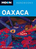

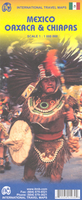
Oaxaca & Chiapas ITMB
Indexed road map covering these provinces in southern Mexico, with plan of central Oaxaca included. Altitude tinting represents the general relief, with spot heights for major peaks, swamp areas and national parks marked. Road detail includes some minor roads and tracks, and shows intermediate distances on major routes. Main railways and province boundaries are drawn and a range of symbols show petrol stations, airports, airfields, archaeological sites, places of interest, beaches, etc. Lines of latitude and longitude are at 1° intervals. The clear plan of Oaxaca emphasizes main routes and indicates sites of interest.This title is part of a series of detailed touring maps of Mexico published by ITMB.

Product Description
Reviews/Comments
Add New
Vouchers
No voucher codes found.
Do you know a voucher code for this product or supplier? Add it to Insights for others to use.
Do you know a voucher code for this product or supplier? Add it to Insights for others to use.
 Denmark