
 United Kingdom
 France
 Germany
 Netherlands
 Sweden
 USA
USA
 Italy
Italy
 Spain
Spain
More From Contributor


North Korea
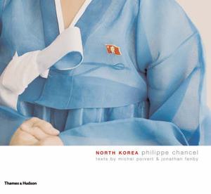
North Korea is truly like no other place on earth. The rulers of this rogue state, the late Kim Il-sung and King Jong-il, have expanded the cult of personality to unprecedented lengths. No other country, no other system, has ever created an environment of such ubiquitous propaganda. In one of the most distinctive photographic collections of the year, Philippe Chancel shows how the political has been transfigured into a breathtaking and all-encompassing aesthetic, and a totalitarian vision for a totalitarian regime.

Product Description
Reviews/Comments
Add New
Vouchers
No voucher codes found.
Do you know a voucher code for this product or supplier? Add it to Insights for others to use.
Do you know a voucher code for this product or supplier? Add it to Insights for others to use.
 Denmark